| During the month of April, Mark Miller will donate $75 to the charity of your choice (5 to chose from, including the Utah Avalanche Center!) Mark Miller Subaru has raised over $300k in the previous 6 Do Good Feel Good events. More Info here |  |
| During the month of April, Mark Miller will donate $75 to the charity of your choice (5 to chose from, including the Utah Avalanche Center!) Mark Miller Subaru has raised over $300k in the previous 6 Do Good Feel Good events. More Info here | |
| Advisory: Logan Area Mountains | Issued by Toby Weed for Wednesday - January 8, 2014 - 6:18am |
|---|

|
bottom line Heightened avalanche conditions exist in the Logan Area backcountry, and snowfall today and intensifying stormy weather tomorrow will create a rising avalanche danger. You could trigger avalanches today, and there is a Level 2 or MODERATE danger on many slopes in the region, mainly at upper elevations. Although rather unlikely today, dangerous persistent slab avalanches remain possible on steep slopes with poor snow structure and are most likely at upper elevations on slopes facing the northern quarter of the compass. Triggered wind slab avalanches are also possible on drifted upper elevation slopes. Accumulating snow today and tomorrow on existing very weak snow will cause the avalanche danger to rise in the backcountry. Evaluate the snow and terrain carefully, and continue to avoid steep drifted slopes, especially at upper elevations.
|
 |
special announcement -Sign up now for our Avalanche 101 course to be held in Logan this week, on January 9 and 11................. Information and registration
|
 |
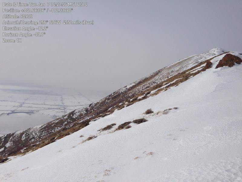
current conditions The Tony Grove Snotel at 8400' reports about an inch of accumulation from yesterday. It's 25 degrees this morning, and there is 34 inches of total snow containing 65% of average water content for the date. The 9700' Logan Peak weather station reports 19 degrees and west southwest wind, currently averaging in the lower teens. It's easy to get the sled stuck if you get off the beaten path and let up on the throttle even a little bit. Even upper elevation slopes have less than 3 feet of total snow, and 1 to 2 feet appears to be the norm. There still just isn't enough snow on most slopes for safe hill-climbing, and so most slopes in the region remain untracked and the snow stability untested. The snow surface is a bit more supportable in general than last week, but it's still punchy in places, especially at mid and lower elevations. In most areas, you can stick the basket end of your ski pole through loose faceted snow all the way to the ground.
The western slopes of the Wellsville Range are in sorry shape. Many are stripped to the bone. We badly need snow in the Logan Area Backcountry. 1-7-2014 A video observation from Deep Canyon 1-7-2014......... HERE
|
 |
recent activity No new avalanches were reported locally since the active natural cycle around Christmas.
|
| type | aspect/elevation | characteristics |
|---|

|
|
LIKELIHOOD
 LIKELY
UNLIKELY
SIZE
 LARGE
SMALL
TREND
 INCREASING DANGER
SAME
DECREASING DANGER
|
|
description
Dangerous human triggered avalanches failing in old weak faceted snow or in the basal layers of the existing snow pack are possible on slopes facing northwest through north and northeast, especially in drifted upper elevation terrain. The energy is all but gone from the slabs due to sublimation and resultant faceting of the more cohesive slab layers. But you can still find numerous slopes with very poor snow structure, deep layers of very weak sugary or faceted snow capped by deteriorating slabs. Although gradually becoming less and less likely, you could still trigger large and unmanageable avalanches on some steep slopes. New snow accumulating in the next couple days is likely to reactivate the buried weak layers, and persistent slab avalanches will once again top the danger priority list. Expect dangerous conditions to develop by tomorrow afternoon in some areas..
|
| type | aspect/elevation | characteristics |
|---|

|
|
LIKELIHOOD
 LIKELY
UNLIKELY
SIZE
 LARGE
SMALL
TREND
 INCREASING DANGER
SAME
DECREASING DANGER
|
|
description
Heightened wind slab avalanche conditions exist in exposed upper elevation terrain. Triggered wind slab avalanches are possible on steep slopes with recent and older deposits of drifted snow. You'll find wind slabs composed of stiffer snow in areas where decelerating winds deposit drifting snow. Wind slabs form on the lee side of exposed ridge lines, but can also form on any slope aspect, especially in and around terrain features like gullies, scoops, sub-ridges, rock outcroppings, and cliff bands. As usual, you should continue to avoid steep slopes with recent wind deposits, which are often smooth, rounded and chalky looking, and can sound hollow or drum-like. As new snow accumulates today, it will be easily drifted into fresh wind slabs in exposed terrain. These will likely be small and manageable today, but they'll probably become more significant by tomorrow.
|
 |
weather We'll see snow in the mountains today, with 3 to 5 inches of accumulation forecast by this evening. Expect 8500' high temperatures around 24 degrees and moderate west southwest winds. Temperatures will drop to around 19 degrees overnight, moderate southwest winds will continue, and 2 to 4 inches of accumulation is possible. Tomorrow looks downright stormy, will increasing westerly winds and possibly heavy snowfall, with up to around a foot of new snow possible in the twelve hour period ending tomorrow evening. Unsettled weather should continue through the coming weekend, and dangerous avalanche conditions are very likely to develop in the backcountry, with another good shot of weather and accumulation likely Saturday night into Sunday. Check out our one stop weather page........HERE |
| general announcements Utah Avalanche Center mobile app - Get your advisory on your iPhone along with great navigation and rescue tools. Discount lift tickets are now available at Backcountry.com - Thanks to Ski Utah and the Utah Resorts, including Beaver Mountain. All proceeds go towards paying for Utah Avalanche Center avalanche and mountain weather advisories. -The Utah Avalanche Center along with the Montana State University Ski Tracks project combines GPS technology with detailed logbook surveys completed by participants to help us understand how and why decisions are made in the winter backcountry. Participants will use a free smartphone app to record and send us their ski routes then, they will complete a simple online survey telling us some of the features of their tour. For more information visit: www.montana.edu/snowscience/tracks Benefit the Utah Avalanche Center when you shop from Backcountry.com or REI: Click this link for Backcountry.com or this link to REI, shop, and they will donate a percent of your purchase price to the UAC. Both offer free shipping (with some conditions) so this costs you nothing! Benefit the Utah Avalanche Center when you buy or sell on ebay - set the Utah Avalanche Center as a favorite non-profit in your ebay account here and click on ebay gives when you buy or sell. You can choose to have your seller fees donated to the UAC, which doesn't cost you a penny. Remember your information can save lives. If you see anything we should know about, please participate in the creation of our own community avalanche advisory by submitting snow and avalanche conditions. You can also call us at 801-524-5304 or 800-662-4140, email by clicking HERE, or include #utavy in your tweet or Instagram. Follow us at UAClogan on Twitter I'll issue these advisories on Monday, Wednesday, Friday, and Saturday mornings. This advisory is produced by the U.S.D.A. Forest Service, which is solely responsible for its content. It describes only general avalanche conditions and local variations always exist. |


_1.jpg)