| During the month of April, Mark Miller will donate $75 to the charity of your choice (5 to chose from, including the Utah Avalanche Center!) Mark Miller Subaru has raised over $300k in the previous 6 Do Good Feel Good events. More Info here |  |
| During the month of April, Mark Miller will donate $75 to the charity of your choice (5 to chose from, including the Utah Avalanche Center!) Mark Miller Subaru has raised over $300k in the previous 6 Do Good Feel Good events. More Info here | |
| Advisory: Logan Area Mountains | Issued by Toby Weed for Monday - January 6, 2014 - 6:45am |
|---|


|
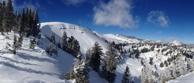
bottom line Heightened avalanche conditions exist in the Logan Area backcountry. You could trigger avalanches, and there is a Level 2 or MODERATE danger on many slopes in the region. Dangerous persistent slab avalanches are possible on steep slopes with poor snow structure and most likely at upper elevations on slopes facing the northern quarter of the compass. Triggered wind slab avalanches are also possible on drifted upper and mid-elevation slopes. You'll find safer conditions, more stable snow, and fast fun riding on sunny south and west facing slopes, at lower and mid elevations, and in lower angled terrain. Evaluate the snow and terrain carefully, and continue to avoid steep drifted slopes, especially at upper elevations.
|
 |
special announcement -Sign up now for our Avalanche 101 course to be held in Logan on January 9 and 11................. Information and registration
|
 |
current conditions The Tony Grove Snotel at 8400' reports a couple inches of new snow over the weekend. It's 11 degrees this morning, and there is 35 inches of total snow containing 66% of average water content for the date. The 9700' Logan Peak weather station reports 7 degrees and west northwest wind, currently averaging a bit under 30 mph, as has been the case for the last several hours.. You can find nice fast and smooth shallow powder conditions, with lower angled and south facing slopes riding well. The snow is a bit more supportable in general than last week, but it's still punchy in places, especially at mid and lower elevations. There are still numerous north and northeast facing slopes in the zone that remain untracked and untested, and that I am unwilling to jump on.
An example of a slope I'm not willing to be the first one to try. "Big Cornice" off Cornice Ridge. 1-5-2014
|
 |
recent activity Other than a few small naturals involving the couple inches of new snow, no new avalanches were reported in the Logan Area over the weekend.
|
| type | aspect/elevation | characteristics |
|---|

|
|
LIKELIHOOD
 LIKELY
UNLIKELY
SIZE
 LARGE
SMALL
TREND
 INCREASING DANGER
SAME
DECREASING DANGER
|
|
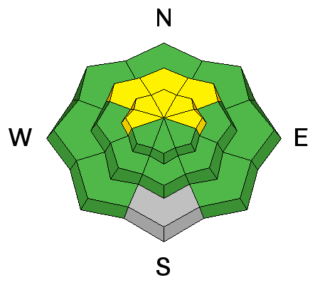
description
Dangerous human triggered avalanches failing in old weak faceted snow or in the basal layers of the existing snow pack are possible on slopes facing northwest through north and northeast, especially in drifted upper elevation terrain. The energy is all but gone from the slabs due to sublimation and resultant faceting of the more cohesive slab layers. But you can still find numerous slopes with very poor snow structure, deep layers of very weak sugary or faceted snow capped by deteriorating slabs. Although gradually becoming less and less likely, you could still trigger large and unmanageable avalanches on some steep slopes. There are hundreds of avalanche prone slopes in the area that remain untracked and untested due to the dangerously shallow snowpack. Among these are many that I won't dare to get out on. A video observation from last week (1-2-2014) in Steep Hollow illustrates why.....HERE
|
| type | aspect/elevation | characteristics |
|---|

|
|
LIKELIHOOD
 LIKELY
UNLIKELY
SIZE
 LARGE
SMALL
TREND
 INCREASING DANGER
SAME
DECREASING DANGER
|
|
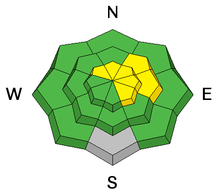
description
Heightened wind slab avalanche conditions exist in exposed upper elevation terrain. Triggered wind slab avalanches are possible on steep slopes with recent and older deposits of drifted snow. You'll find wind slabs composed of stiffer snow in areas where decelerating winds deposit drifting snow. Wind slabs form on the lee side of exposed ridge lines, but can also form on any slope aspect, especially in and around terrain features like gullies, scoops, sub-ridges, rock outcroppings, and cliff bands. As usual, you should continue to avoid steep slopes with recent wind deposits, which are often smooth, rounded and chalky looking, and can sound hollow or drum-like.
|
 |
weather A shot-lived ridge of high pressure will build over the region today, bringing milder temperatures and fair weather to the mountains. Expect lots of sun, with 8500' temperatures topping out around 30 degrees and light to moderate northwest winds. The ridge will begin to flatten overnight in advance of a series of weak storms, which will affect our area starting tomorrow and extend through the later part of the week. Small amounts of accumulating snow are expected in each 12 hour period starting tomorrow night and extending through Thursday... Stronger storm events are possible Thursday night and again Sunday, but confidence is still low currently as to the timing and extent of snowfall with these features.... Check out our one stop weather page........HERE |
| general announcements Utah Avalanche Center mobile app - Get your advisory on your iPhone along with great navigation and rescue tools. Discount lift tickets are now available at Backcountry.com - Thanks to Ski Utah and the Utah Resorts, including Beaver Mountain. All proceeds go towards paying for Utah Avalanche Center avalanche and mountain weather advisories. -The Utah Avalanche Center along with the Montana State University Ski Tracks project combines GPS technology with detailed logbook surveys completed by participants to help us understand how and why decisions are made in the winter backcountry. Participants will use a free smartphone app to record and send us their ski routes then, they will complete a simple online survey telling us some of the features of their tour. For more information visit: www.montana.edu/snowscience/tracks Benefit the Utah Avalanche Center when you shop from Backcountry.com or REI: Click this link for Backcountry.com or this link to REI, shop, and they will donate a percent of your purchase price to the UAC. Both offer free shipping (with some conditions) so this costs you nothing! Benefit the Utah Avalanche Center when you buy or sell on ebay - set the Utah Avalanche Center as a favorite non-profit in your ebay account here and click on ebay gives when you buy or sell. You can choose to have your seller fees donated to the UAC, which doesn't cost you a penny. Remember your information can save lives. If you see anything we should know about, please participate in the creation of our own community avalanche advisory by submitting snow and avalanche conditions. You can also call us at 801-524-5304 or 800-662-4140, email by clicking HERE, or include #utavy in your tweet or Instagram. Follow us at UAClogan on Twitter I'll issue these advisories on Monday, Wednesday, Friday, and Saturday mornings. This advisory is produced by the U.S.D.A. Forest Service, which is solely responsible for its content. It describes only general avalanche conditions and local variations always exist. |


_1.jpg)