| During the month of April, Mark Miller will donate $75 to the charity of your choice (5 to chose from, including the Utah Avalanche Center!) Mark Miller Subaru has raised over $300k in the previous 6 Do Good Feel Good events. More Info here |  |
| During the month of April, Mark Miller will donate $75 to the charity of your choice (5 to chose from, including the Utah Avalanche Center!) Mark Miller Subaru has raised over $300k in the previous 6 Do Good Feel Good events. More Info here | |
| Advisory: Logan Area Mountains | Issued by Toby Weed for Wednesday - January 1, 2014 - 6:57am |
|---|

|
bottom line Heightened avalanche conditions exist in the Logan Area backcountry, and there is a Level 2 or MODERATE danger on drifted mid and upper elevation slopes. Wind and persistent slab avalanches are possible in drifted terrain, and most likely at upper elevations. You'll find more stable and safer conditions in sheltered mid-elevation terrain and at lower elevations, though the snow is still quite shallow, and the danger of hitting rocks and down trees is significant. Evaluate the snow and terrain carefully, and avoid steep drifted slopes.
|
 |
special announcement Come join us for a FREE, informal talk on Thursday January 2 at 6pm at the Cafe Ibis where Utah Avalanche Center forecaster Toby Weed will discuss current conditions and any topic that seems pertinent to snow and avalanche conditions. For more info call 435-757-2794. -Sign up now for our Avalanche 101 course to be held in Logan on January 9 and 11................. Information and registration
|
 |
current conditions The Tony Grove Snotel at 8400' reports 3 inches of new snow. It's 23 degrees this morning, and there is 35 inches of total snow containing 68% of average water content for the date. The 9700' Logan Peak weather station reports 17 degrees and northwest wind, currently averaging a bit less than 10 mph after a night of recording westerly winds averaging over 20 mph. We found smooth and fast shallow powder conditions best in lower angled terrain, yesterday. Many area are punchy and you easily sink down into structureless sugary snow. You'll still find pockets of dangerous avalanche conditions in drifted terrain at upper elevations in the Logan Area backcountry.
Looking toward Bear Lake from the Garden City Bowls on 12-30-2013. (McAvoy)
|
 |
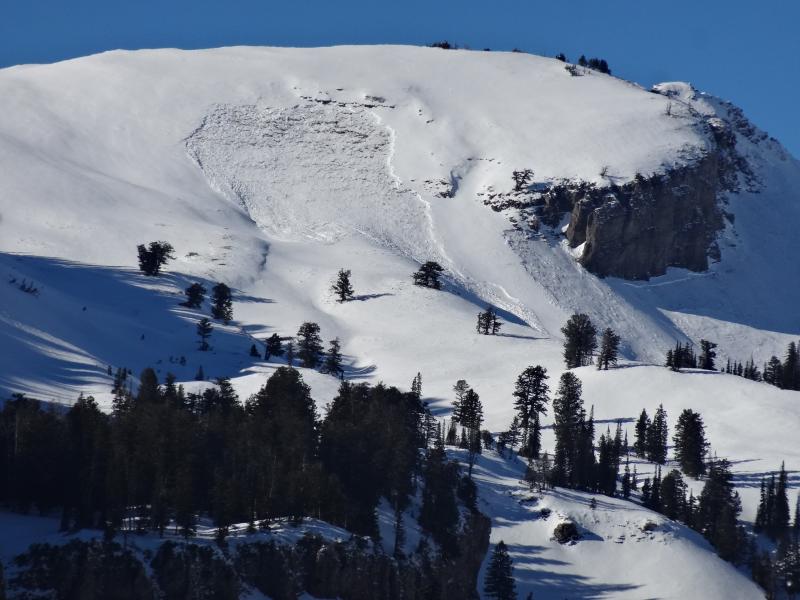
recent activity A fairly widespread natural avalanche cycle occurred in the Central Bear River Range as an energetic cold front passed through the region early Christmas Eve. The hard and soft slab avalanches occurred on northwest, north, northeast, east, and southeast facing slopes above around 8200' in elevation. They ranged from fairly small (around a foot deep and 30' wide) to pretty big, like the ones on Cornice Ridge and in the Mount Naomi Wilderness that were both around a meter deep and a 1/4 to 1/2 mile wide... A more recent natural slab release was also observed north of Mount Elmer during the recent warm and sunny spell on 12-27-2013. No new avalanches were reported locally since.
Here's a look at a the broad crown of a natural avalanche in the Mount Naomi Wilderness that occurred early Christmas Eve (Rosenberg). A video look at the Cornice Ridge Avalanche from 12-26-2013 observation......... HERE |
| type | aspect/elevation | characteristics |
|---|

|
|
LIKELIHOOD
 LIKELY
UNLIKELY
SIZE
 LARGE
SMALL
TREND
 INCREASING DANGER
SAME
DECREASING DANGER
|
|
description
Drifting yesterday and overnight caused the development of wind slabs, in many cases on top of very week preexisting snow. Heightened wind slab avalanche conditions exist in exposed upper and mid-elevation terrain. Triggered wind slab avalanches are possible on steep slopes with recent and older deposits of drifted snow. You'll find wind slabs composed of stiffer snow in areas where decelerating winds deposit drifting snow. Wind slabs form on the lee side of ridge lines, but can form on any slope aspect in exposed terrain, especially in and around terrain features like gullies, scoops, sub-ridges, rock outcroppings, and cliff bands. As usual, it's wise to avoid steep drifted slopes. |
| type | aspect/elevation | characteristics |
|---|

|
|
LIKELIHOOD
 LIKELY
UNLIKELY
SIZE
 LARGE
SMALL
TREND
 INCREASING DANGER
SAME
DECREASING DANGER
|
|
description
The new snow from just before Christmas piled up and was drifted onto preexisting very weak sugary or faceted snow, which is widespread in the region, creating a slab layer on many slopes. In most areas sublimation and has deteriorated the slab, and it no longer possesses the cohesive properties needed for avalanching. But, in some areas where the slab layer is harder, persistent slab avalanches are possible. Same old problem; a decreasing probability of triggering, but the consequences of doing so remain very serious. Dangerous human triggered avalanches failing in old weak faceted snow or in the basal layers of the existing snow pack remain possible in some areas facing northwest through east, especially in drifted upper elevation terrain.
|
 |
weather Expect clearing today as the latest wave of unsettled weather exits to the east. Skies should be mostly clear by afternoon, and mountain temperatures will rise to around 28 degrees. Expect moderate but sustained west northwest winds, averaging in the upper teens, and continued drifting at upper elevations. It'll be party cloudy overnight with mountain temperatures dropping to around 18 degrees. Expect warmer mostly sunny weather in the mountains tomorrow with a high temperature around 34 degrees and lighter southwest wind. A storm Friday and Saturday looks only a little stronger than yesterday's brush-by, but it might be a bit more productive if things come together. At this point snowfall should start on Friday with little accumulation, but windy conditions. 2 to 4 inches are currently forecast for Friday night, and 1 to 3 for Saturday.... Check out our one stop weather page........HERE |
| general announcements The Utah Avalanche Center wishes you a safe and powder-filled holiday season. Please consider the UAC in your holiday giving plans - your donations pay for these advisories and we can't do this without your help. What is it worth to you every day to get an avalanche and mountain weather advisory? The cost of a beverage or the gas it takes to get up the canyon? You can donate here. Utah Avalanche Center mobile app - Get your advisory on your iPhone along with great navigation and rescue tools. Discount lift tickets are now available at Backcountry.com - Thanks to Ski Utah and the Utah Resorts, including Beaver Mountain. All proceeds go towards paying for Utah Avalanche Center avalanche and mountain weather advisories. Benefit the Utah Avalanche Center when you shop from Backcountry.com or REI: Click this link for Backcountry.com or this link to REI, shop, and they will donate a percent of your purchase price to the UAC. Both offer free shipping (with some conditions) so this costs you nothing! Benefit the Utah Avalanche Center when you buy or sell on ebay - set the Utah Avalanche Center as a favorite non-profit in your ebay account here and click on ebay gives when you buy or sell. You can choose to have your seller fees donated to the UAC, which doesn't cost you a penny. Remember your information can save lives. If you see anything we should know about, please participate in the creation of our own community avalanche advisory by submitting snow and avalanche conditions. You can also call us at 801-524-5304 or 800-662-4140, email by clicking HERE, or include #utavy in your tweet or Instagram. -The Utah Avalanche Center along with the Montana State University Ski Tracks project combines GPS technology with detailed logbook surveys completed by participants to help us understand how and why decisions are made in the winter backcountry. Participants will use a free smartphone app to record and send us their ski routes then, they will complete a simple online survey telling us some of the features of their tour. For more information visit: www.montana.edu/snowscience/tracks Follow us at UAClogan on Twitter I'll issue these advisories on Monday, Wednesday, Friday, and Saturday mornings. This advisory is produced by the U.S.D.A. Forest Service, which is solely responsible for its content. It describes only general avalanche conditions and local variations always exist. |


_1.jpg)