
| During the month of April, Mark Miller will donate $75 to the charity of your choice (5 to chose from, including the Utah Avalanche Center!) Mark Miller Subaru has raised over $300k in the previous 6 Do Good Feel Good events. More Info here |  |
| During the month of April, Mark Miller will donate $75 to the charity of your choice (5 to chose from, including the Utah Avalanche Center!) Mark Miller Subaru has raised over $300k in the previous 6 Do Good Feel Good events. More Info here | |
| Advisory: Logan Area Mountains | Issued by Toby Weed for Monday - December 23, 2013 - 6:39am |
|---|

|
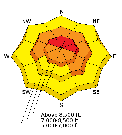
bottom line Very dangerous avalanche conditions exist in the backcountry, and there is a Level 4 or HIGH danger on drifted upper elevation slopes. Dangerous wind slab, persistent slab, and storm snow avalanche conditions are widespread across the Logan Zone at upper and mid elevations due to significant fresh accumulations, drifting, and very weak preexisting faceted snow. You could trigger avalanches remotely, from a distance or below. Avoid travel in all avalanche terrain. Stay off of and out from under steep slopes and obvious or historic avalanche paths..
|
 |
special avalanche bulletin THIS SPECIAL AVALANCHE BULLETIN IS FOR THE MOUNTAINS OF NORTHERN UTAH TO INCLUDE THE WESTERN UINTAS. A HIGH AVALANCHE DANGER EXISTS FOR MOST OF THE MOUNTAINS OF NORTHERN UTAH. VISIT WWW.UTAHAVALANCHECENTER FOR MORE DETAILS. THIS ADVISORY DOES NOT INCLUDE SKI AREAS OR HIGHWAYS WHERE AVALANCHE CONTROL IS NORMALLY DONE. |
 |
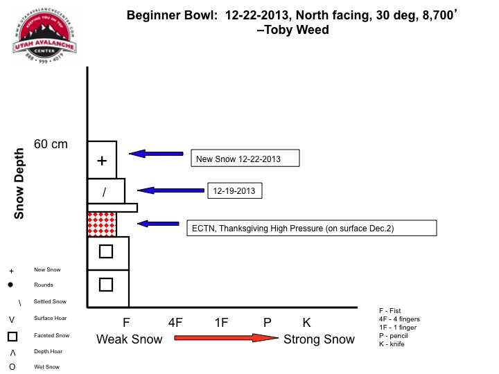
current conditions You'll find very dangerous avalanche conditions in the backcountry, but Beaver Mountain opens today, so you can ride the lifts and enjoy the powder. The Tony Grove Snotel at 8400' reports several inches of rimed new snow and some freezing drizzle in the last 24 hours, containing 0.6 of an inch of water. It's 25 degrees this morning, and there is 34 inches of total snow containing 64% of average water content for the date. The 9700' Logan Peak weather station reports 20 degrees and the wind sensor is rimed or covered with ice. The UDOT Hwy 89 Logan Summit weather station recorded northwest winds last night averaging around 20 mph. We found difficult traveling conditions in the Tony Grove Area yesterday. It's easy to get the sled stuck in bottomless sugary snow if you venture off the packed trail, and hiking uphill is arduous because you sink in too deeply. Widespread, very weak preexisting faceted snow plagues the shallow snow on most slopes in the region, and is especially bad on upper and mid elevation slopes facing the northern half of the compass.
Pretty good representation of much of the northerly facing terrain out there. Very weak faceted snow with soft fresh snow on top currently lacking slab properties. But, drifting and additional snowfall are changing things rapidly and avalanches are likely in many areas where a slab is forming. A short video clip showing arduous the hiking conditions in the Tony Grove Area on 12-22-2013...... HERE
|
 |
recent activity Ski resorts from the Ogden and Salt Lake Area Mountains report very active avalanche control results from the weekend, and there were several human triggered avalanches in the Wasatch and Uinta backcountry, including a couple close calls. UDOT reports significant natural activity overnight in Little Cottonwood Canyon. No avalanches were reported locally, but there certainly is real potential.
Here's a picture of one of many scary human triggered avalanches from the weekend in the Wasatch Range. (Patsy Marley,Hutchinson)
|
| type | aspect/elevation | characteristics |
|---|

|
|
LIKELIHOOD
 LIKELY
UNLIKELY
SIZE
 LARGE
SMALL
TREND
 INCREASING DANGER
SAME
DECREASING DANGER
|
|
description
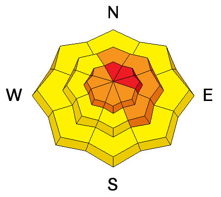
Drifting of the fresh new snow caused the development of wind slabs, in many cases on top of very week preexisting snow. Very dangerous conditions exist in exposed upper elevation terrain. Natural and triggered wind slab avalanches are likely on steep slopes with significant fresh deposits of drifted snow. You'll find wind slabs composed of stiffer snow in exposed lee slope terrain, especially in and around terrain features like gullies, scoops, sub-ridges, rock outcroppings, and cliff bands. We recommend that you avoid travel in all steep drifted terrain.
|
| type | aspect/elevation | characteristics |
|---|

|
|
LIKELIHOOD
 LIKELY
UNLIKELY
SIZE
 LARGE
SMALL
TREND
 INCREASING DANGER
SAME
DECREASING DANGER
|
|
description
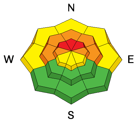
The Tony Grove Snotel reports nearly 2 inches of water from snowfall since Thursday. The new snow piled up and was drifted onto preexisting very weak sugary or faceted snow, which is widespread in the region. Natural and dangerous human triggered avalanches failing in old weak faceted snow or in the basal layers of the existing snow pack are likely in drifted terrain and in areas that picked up significant quantities of new snow. You could trigger persistent slab avalanches remotely or from a distance, and this could be an especially bad scene if you trigger one from below. Collapsing and/or shooting cracks are obvious red flags requiring you to reevaluate your route. Avoid and stay out from under steep slopes, slopes connected to steep slopes, and obvious or historic avalanche paths. |
| type | aspect/elevation | characteristics |
|---|

|
|
LIKELIHOOD
LIKELY
UNLIKELY
SIZE
LARGE
SMALL
TREND
INCREASING DANGER
SAME
DECREASING DANGER
|
|
description
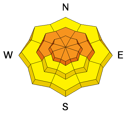
In steep terrain, you are likely to trigger fairly large soft slab avalanches failing on weak preexisting surface snow or within the new snow since Thursday. Natural avalanches are possible as well, so you should stay out from under steep slopes and avalanche paths. |
 |
weather Unsettled and moist weather will continue through Tuesday, then a high pressure system will build into the region bringing mild and fair weather to the mountains and inversion conditions in the valleys. It'll be cloudy today with a 30% chance of snow, but not much in the way of accumulation. 8500' high temperatures should reach around 29 degrees and there will be a moderate west southwest breeze. Mountain temperatures will drop into the mid twenties overnight and there's a chance for an inch or two of accumulation. We might see a spot of sunshine tomorrow afternoon, with snow possible in the morning, mountain temperatures around 20 degrees and a bit stronger west northwest wind. Looks like it'll be sunny and nice in the mountains on Christmas Day! Check out our one stop weather page........HERE |
| general announcements The Utah Avalanche Center wishes you a safe and powder-filled holiday season. Please consider the UAC in your holiday giving plans - your donations pay for these advisories and we can't do this without your help. What is it worth to you every day to get an avalanche and mountain weather advisory? The cost of a beverage or the gas it takes to get up the canyon? You can donate here. Utah Avalanche Center mobile app - Get your advisory on your iPhone along with great navigation and rescue tools. Discount lift tickets are now available at Backcountry.com - Thanks to Ski Utah and the Utah Resorts, including Beaver Mountain. All proceeds go towards paying for Utah Avalanche Center avalanche and mountain weather advisories. Benefit the Utah Avalanche Center when you shop from Backcountry.com or REI: Click this link for Backcountry.com or this link to REI, shop, and they will donate a percent of your purchase price to the UAC. Both offer free shipping (with some conditions) so this costs you nothing! Benefit the Utah Avalanche Center when you buy or sell on ebay - set the Utah Avalanche Center as a favorite non-profit in your ebay account here and click on ebay gives when you buy or sell. You can choose to have your seller fees donated to the UAC, which doesn't cost you a penny. Remember your information can save lives. If you see anything we should know about, please participate in the creation of our own community avalanche advisory by submitting snow and avalanche conditions. You can also call us at 801-524-5304 or 800-662-4140, email by clicking HERE, or include #utavy in your tweet or Instagram. Sign up early for one of our life-saving avalanche classes.......HERE And refresh your avalanche knowledge, check out some of our tutorials........HERE Follow us at UAClogan on Twitter I'll issue these advisories on Monday, Wednesday, Friday, and Saturday mornings. This advisory is produced by the U.S.D.A. Forest Service, which is solely responsible for its content. It describes only general avalanche conditions and local variations always exist. |


_1.jpg)

.jpg)