| During the month of April, Mark Miller will donate $75 to the charity of your choice (5 to chose from, including the Utah Avalanche Center!) Mark Miller Subaru has raised over $300k in the previous 6 Do Good Feel Good events. More Info here |  |
| During the month of April, Mark Miller will donate $75 to the charity of your choice (5 to chose from, including the Utah Avalanche Center!) Mark Miller Subaru has raised over $300k in the previous 6 Do Good Feel Good events. More Info here | |
| Advisory: Logan Area Mountains | Issued by Toby Weed for Friday - December 20, 2013 - 6:50am |
|---|

|
bottom line Dangerous avalanche conditions exist in the backcountry due to heavy snowfall yesterday on widespread preexisting very weak faceted snow and increasing drifting today. There is a Level 3 or CONSIDERABLE danger on mid and upper elevation slopes. Natural avalanches are possible and triggered avalanches likely in drifted terrain and in areas with significant fresh accumulations. You could trigger avalanches remotely, from a distance or below. Avoid and stay out from under steep drifted slopes and obvious or historic avalanche paths. Very shallow and rocky early season snow conditions still exist across the Logan Zone. Careful snowpack evaluation, cautious route-finding, and conservative decision making will be essential for safe travel in the backcountry this weekend.
|
 |
special avalanche bulletin Heavy snowfall on widespread very weak preexisting snow created dangerous avalanche conditions in the backcountry. Natural avalanches are possible and dangerous human triggered avalanches are likely in in drifted terrain and in areas with significant accumulations of new snow. |
 |
current conditions The Tony Grove Snotel at 8400' reports 7" of new snow from yesterday's storm containing 3/5 of an inch of water equivalent. It's 13 degrees this morning, and there is 28 inches of total snow containing 56% of average water content for the date. The 9700' Logan Peak weather station reports 6 degrees and gradually increasing northwest winds, currently averaging around 14 mph this morning. The fresh snow came in on a variable old snow surface; wind-jacked and sun-crusted in exposed terrain, rotten, weak, and unsupportable in more sheltered and shady areas. Widespread, very weak preexisting faceted snow plagues the shallow snow on most slopes in the region, and is especially bad on upper and mid elevation slopes facing the northern half of the compass. The Tony Grove Road is not maintained for wheeled travel in the winter, and the road is currently very snowy, icy, and treacherous in places. A sled or a 4-wheel-drive vehicle and chains are recommended.
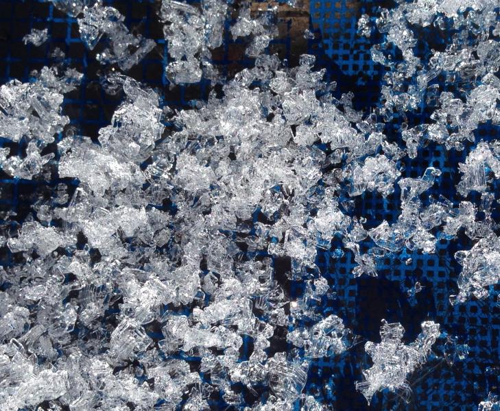
Faceted snow is widespread, very weak and getting weaker. This photo was taken on 12-17-2013 in the White's Bedground Area off Red Pine Ridge.
A video observation from Red Pine Ridge 12-17-2013 is HERE
|
 |
recent activity Ski resorts from the Ogden and Salt Lake Area Mountains report an active avalanche control day yesterday, and there were several human triggered avalanches in the Wasatch backcountry, including at least one close call. Few people were out locally yesterday, and I didn't get any reports...
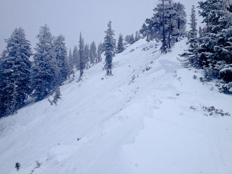
Here's a picture of a human triggered avalanche and a close call from yesterday in the Wasatch Range. (Davenport Hill) |
| type | aspect/elevation | characteristics |
|---|

|

|
LIKELIHOOD
 LIKELY
UNLIKELY
SIZE
 LARGE
SMALL
TREND
 INCREASING DANGER
SAME
DECREASING DANGER
|
|
description
After a calm day in the mountains yesterday, northwest winds are gradually increasing this morning, a trend that will continue throughout the day. Drifting will cause the development of wind slabs, in many cases on very week preexisting snow. Natural wind slab avalanches are possible and triggered avalanches likely today on steep slopes with a foot or more of accumulated new and especially drifted snow. You'll find forming and potentially sensitive wind slabs composed of stiffer snow in exposed lee slope terrain, especially in and around terrain features like gullies, scoops, sub-ridges, rock outcroppings, and cliff bands. We recommend that you avoid travel in all steep drifted terrain this weekend.
|
| type | aspect/elevation | characteristics |
|---|

|

|
LIKELIHOOD
LIKELY
UNLIKELY
SIZE
 LARGE
SMALL
TREND
INCREASING DANGER
SAME
DECREASING DANGER
|
|
description
Yesterday's heavy new snow piled up on preexisting very weak sugary or faceted snow, which is widespread in the region. Natural avalanches failing in old weak faceted snow or in the basal layers of the existing snow pack are possible, and dangerous human triggered avalanches are likely in drifted terrain and in areas that picked up a foot or more of heavy new snow. You could trigger persistent slab avalanches remotely or from a distance, and this could be an especially bad scene if you trigger one from below. Collapsing and/or shooting cracks are obvious red flags requiring you to reevaluate your route. Avoid and stay out from under steep slopes, slopes connected to steep slopes and obvious or historic avalanche paths this weekend. |
 |
weather Expect mostly cloudy skies, increasing west winds, a chance for a bit of snow in the afternoon, and 8500' high temperatures around 21 degrees today. Expect snow tonight, 3 to 7 inches of accumulation forecast, with increasing and sustained west winds and temperatures in the mid-teens. The avalanche danger is likely to rise further tomorrow, with continued accumulating snowfall and fairly strong and sustained northwest winds, and a HIGH danger is quite possible in some areas. Unsettled weather will continue through Sunday. A high pressure system will bring warming temperatures for the first part of next week, but the inversion should hold off for a few days. Check out our one stop weather page........HERE |
| general announcements Sign up early for one of our life-saving avalanche classes.......HERE And refresh your avalanche knowledge, check out some of our tutorials........HERE Follow us at UAClogan on Twitter Utah Avalanche Center mobile app - Get your advisory on your iPhone along with great navigation and rescue tools. Discount lift tickets are now available at Backcountry.com - Thanks to Ski Utah and the Utah Resorts, including Beaver Mountain. All proceeds go towards paying for Utah Avalanche Center avalanche and mountain weather advisories. Benefit the Utah Avalanche Center when you shop from Backcountry.com or REI: Click this link for Backcountry.com or this link to REI, shop, and they will donate a percent of your purchase price to the UAC. Both offer free shipping (with some conditions) so this costs you nothing! Benefit the Utah Avalanche Center when you buy or sell on ebay - set the Utah Avalanche Center as a favorite non-profit in your ebay account here and click on ebay gives when you buy or sell. You can choose to have your seller fees donated to the UAC, which doesn't cost you a penny. Remember your information can save lives. If you see anything we should know about, please participate in the creation of our own community avalanche advisory by submitting snow and avalanche conditions. You can also call us at 801-524-5304 or 800-662-4140, email by clicking HERE, or include #utavy in your tweet or Instagram. I'll issue advisories on Monday, Wednesday, Friday, and Saturday mornings. This advisory is produced by the U.S.D.A. Forest Service, which is solely responsible for its content. It describes only general avalanche conditions and local variations always exist. |


_1.jpg)