| During the month of April, Mark Miller will donate $75 to the charity of your choice (5 to chose from, including the Utah Avalanche Center!) Mark Miller Subaru has raised over $300k in the previous 6 Do Good Feel Good events. More Info here |  |
| During the month of April, Mark Miller will donate $75 to the charity of your choice (5 to chose from, including the Utah Avalanche Center!) Mark Miller Subaru has raised over $300k in the previous 6 Do Good Feel Good events. More Info here | |
| Advisory: Logan Area Mountains | Issued by Toby Weed for Monday - December 16, 2013 - 6:16am |
|---|

|
bottom line Heightened avalanche conditions exist and there's a level 2 or MODERATE danger on drifted slopes at upper elevations. Avoid steep rocky and previously drifted terrain and steep slopes with poor snow structure, where you still might trigger dangerous wind or persistent slab avalanches. Loose avalanches or sluffs entraining significant unconsolidated or wet snow are possible and growing more likely on steep slopes. Very shallow and rocky early season snow conditions exist across the Logan Zone. Evaluate the snow and terrain carefully.
|
 |
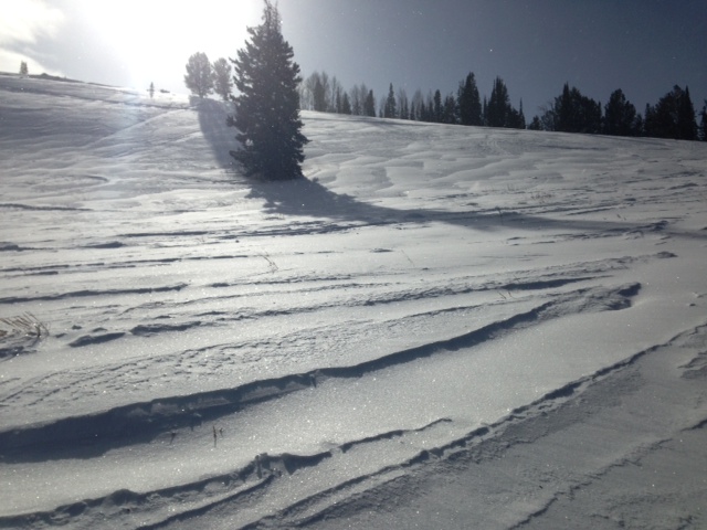
current conditions The Tony Grove Snotel at 8400' reports 34 degrees this morning, and there is 23 inches of total snow containing 56% of average water equivalent for the date. The 9700' Logan Peak weather station reports 25 degrees and west winds averaging a bit under 25 mph. Conditions are quite variable, wind-jacked and sun-crusted in exposed terrain, rotten and unsupportable in more sheltered and shady areas. Hitting buried rocks is becoming more likely in more places because the shallow snow pack continues to weaken and become even more unsupportable. The Tony Grove Road is not maintained for wheeled travel in the winter, and the road is currently very snowy, icy, and treacherous in places. A sled or a 4-wheel-drive vehicle and chains are recommended. You still have to stay on the roads or in smooth grassy meadows with your sled or you'll sink right through the sugary snow, and you could do significant damage to your sled or yourself by hitting rocks. The lifts at Beaver Mountain are still closed due to shallow snow conditions, but they allow you to hike uphill, and welcome the help packing out what's there.
|
 |
recent activity Locally: Other than a few sluffs, no significant avalanches were recently reported or observed.
|
| type | aspect/elevation | characteristics |
|---|

|
|
LIKELIHOOD
 LIKELY
UNLIKELY
SIZE
 LARGE
SMALL
TREND
 INCREASING DANGER
SAME
DECREASING DANGER
|
|
description
Heightened wind and persistent slab avalanche conditions continue in upper elevation terrain. Slabs built up on top of preexisting very weak sugary or faceted snow, which is widespread in the region due to the prolonged Thanksgiving high pressure system. You'll find stiff old wind slabs in exposed terrain, especially in and around terrain features like gullies, scoops, sub-ridges, rock outcroppings and cliff bands. There are also some fresher wind slabs from drifting late last week and over the weekend. You could trigger persistent hard slab avalanches if you venture into steep terrain in some areas, and some avalanches still might be triggered remotely, from a distance, or worse from below. You don't want to be caught and carried by any size avalanche, with very shallow snow and sharp rocks in runout zones. Collapsing and/or shooting cracks are obvious red flags requiring you to reevaluate your route, and you should continue to avoid steep rocky and drifted terrain. |
| type | aspect/elevation | characteristics |
|---|

|
|
LIKELIHOOD
LIKELY
UNLIKELY
SIZE
 LARGE
SMALL
TREND
 INCREASING DANGER
SAME
DECREASING DANGER
|
|
description
I triggered a manageable loose sluff Thursday on a steep north facing mid-elevation slope that entrained sugary snow, ran a bit further than expected, and took out my tracks below. I noticed more dry sluffing in steep northwest facing terrain in Beaver Canyon this weekend. With significant warming of upper elevations in the forecast for the next few days, loose wet avalanches will become more likely on sunny slopes. Although usually manageable, loose avalanches could be a problem in steep terrain, especially around terrain traps like gullies, benches, or rocky ground. I expect the loose snow avalanche problem to increase in scope as high pressure and warming conditions continue and the snow surface further weakens..
|
 |
weather A high pressure system will move overhead, and we can expect milder sunny weather in the mountains and cold smoggy haze in Cache Valley for the first half of the work week at least. 8500' high temperatures are forecast to reach 38 degrees today and moderate west winds will continue. Mountain temperatures will drop into the mid twenties overnight. A weakening storm system swinging through the region on around Thursday may bring a bit of relief from the inversion, but sadly not much in the way of snow.... Check out our one stop weather page........HERE |
| general announcements Sign up early for one of our life-saving avalanche classes.......HERE And refresh your avalanche knowledge, check out some of our tutorials........HERE Follow us at UAClogan on Twitter Utah Avalanche Center mobile app - Get your advisory on your iPhone along with great navigation and rescue tools. Discount lift tickets are now available at Backcountry.com - Thanks to Ski Utah and the Utah Resorts, including Beaver Mountain. All proceeds go towards paying for Utah Avalanche Center avalanche and mountain weather advisories. Benefit the Utah Avalanche Center when you shop from Backcountry.com or REI: Click this link for Backcountry.com or this link to REI, shop, and they will donate a percent of your purchase price to the UAC. Both offer free shipping (with some conditions) so this costs you nothing! Benefit the Utah Avalanche Center when you buy or sell on ebay - set the Utah Avalanche Center as a favorite non-profit in your ebay account here and click on ebay gives when you buy or sell. You can choose to have your seller fees donated to the UAC, which doesn't cost you a penny. Remember your information can save lives. If you see anything we should know about, please participate in the creation of our own community avalanche advisory by submitting snow and avalanche conditions. You can also call us at 801-524-5304 or 800-662-4140, email by clicking HERE, or include #utavy in your tweet or Instagram. I'll issue advisories on Monday, Wednesday, Friday, and Saturday mornings. This advisory is produced by the U.S.D.A. Forest Service, which is solely responsible for its content. It describes only general avalanche conditions and local variations always exist. |


_1.jpg)