| During the month of April, Mark Miller will donate $75 to the charity of your choice (5 to chose from, including the Utah Avalanche Center!) Mark Miller Subaru has raised over $300k in the previous 6 Do Good Feel Good events. More Info here |  |
| During the month of April, Mark Miller will donate $75 to the charity of your choice (5 to chose from, including the Utah Avalanche Center!) Mark Miller Subaru has raised over $300k in the previous 6 Do Good Feel Good events. More Info here | |
| Advisory: Logan Area Mountains | Issued by Toby Weed for Monday - December 9, 2013 - 7:13am |
|---|

|
bottom line Dangerous avalanche conditions exist and there's a CONSIDERABLE (or level 3) danger on drifted slopes at upper elevations. Avoid steep drifted terrain where you are still likely to trigger dangerous wind slab or persistent slab avalanches. Very shallow and rocky early season snow conditions exist across the Logan Zone, so being caught and carried in even a small avalanche could be very dangerous due to rocks, stumps, and downed trees in the runout. Very cold temperatures and extreme wind chill increase the risk of backcountry travel. Careful snowpack evaluation, cautious route-finding, and conservative decision making remain essential.
|
 |
current conditions Arctic cold temperatures continue to up the anti in the backcountry, adding to the danger factor in a few ways. Overall, the snowpack is still quite shallow and rocky across the zone. In many areas you sink to the ground through shallow, weak, and structureless faceted snow, and travel is difficult. The Tony Grove Snotel at 8400' reports 2 inches of new snow in the last 24 hours. It's negative 6 degrees this morning, and there is 27 inches of total snow containing 65% of average water equivalent for the date. The 9700' Logan Peak weather station reports - 12 degrees and northwest winds averaging in the upper teens. I found at least a foot of new snow from Saturday's storm on Maple Bench above Mendon yesterday, so some areas got dumped on while others (like the Central Bear River Range) only picked up a few inches of light snow. The Tony Grove Road is not maintained for wheeled travel in the winter, and the road is currently very snowy, icy, and treacherous in places. A sled or 4-wheel-drive vehicles and chains are recommended. Be ready to get stuck, bring shovels, extra warm gear, and maybe a sleeping bag or two. If you do ride up, remember that there are lots of pedestrians sharing the road, and you have to watch your speed. Beaver Mountain allows uphill foot travel and usually appreciates the help packing in the shallow snow before opening..
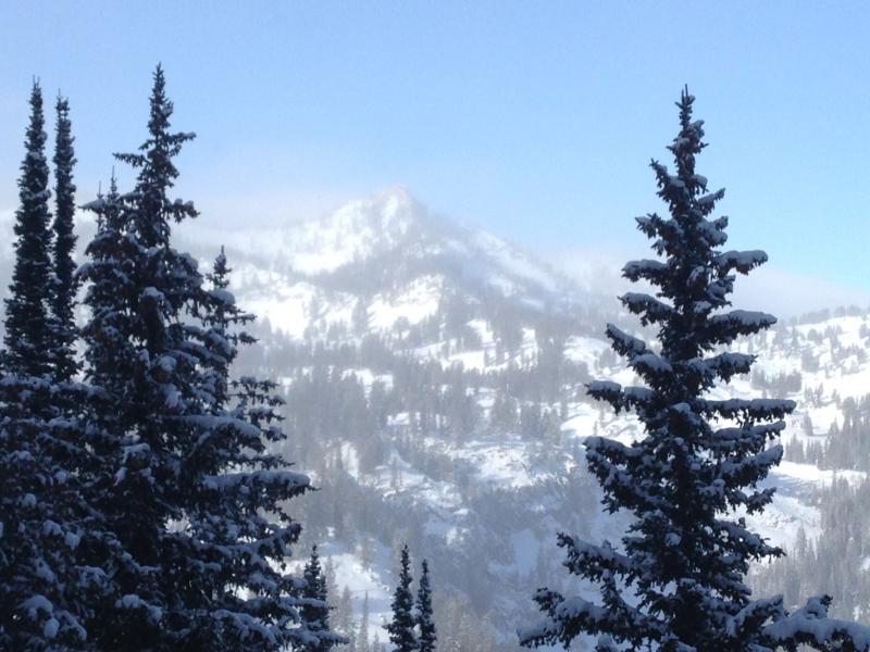
Mt.Magog from the south, shrouded by icy mist on 12-9-2013
A video observation from 12-9-2013 in the Tony Grove Area...... HERE
|
 |
recent activity Numerous triggered avalanches and a few close calls were reported from over the weekend in the mountains above Salt Lake and the Ogden Valley. Several of these avalanches failed and ran on buried weak faceted snow. Locally: A party reported triggering a small wind slab avalanche Friday in the Cornice Ridge Area above Tony Grove Lake. The same party reported localized collapsing and cracking in drifted upper elevation terrain, red flags indicating the existence of unstable snow. The shallow snow and very cold temperatures appear to be keeping most people out of the backcountry, but I'd sure like to hear from you if you make it out this week... |
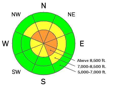
| type | aspect/elevation | characteristics |
|---|

|
|
LIKELIHOOD
 LIKELY
UNLIKELY
SIZE
 LARGE
SMALL
TREND
 INCREASING DANGER
SAME
DECREASING DANGER
|
|
description
Westerly winds increased in the past couple days, drifting the light snow on the surface and creating dangerous avalanche conditions. You'll find freshly formed wind slabs in exposed terrain, especially in and around terrain features like gullies, scoops, sub-ridges, rock outcroppings and cliff bands. You certainly don't want to be caught and carried by any size avalanche, with very shallow snow and sharp rocks in runout zones. Recent avalanches and/or shooting cracks will be obvious red flags requiring you to reevaluate your route, and you should continue to avoid steep drifted terrain. |
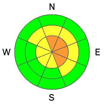
| type | aspect/elevation | characteristics |
|---|

|
|
LIKELIHOOD
 LIKELY
UNLIKELY
SIZE
 LARGE
SMALL
TREND
INCREASING DANGER
SAME
DECREASING DANGER
|
|
description
Dangerous persistent slab avalanche conditions exist in some drifted upper elevation terrain. Slabs on upper and mid-elevation slopes are building up thickness and weight on top of preexisting very weak sugary or faceted snow, which is widespread in the region due to the prolonged Thanksgiving high pressure system. The added weight from snowfall and wind with the weekend storm overloaded the very weak underlying snow on some slopes. You are likely to trigger dangerous avalanches if you venture into steep terrain in some areas, and persistent slab avalanches could be triggered remotely, from a distance, or worse from below. Avoid steep slopes with poor snow structure, (where a slab consisting of stiffer snow sits on top of weak sugary or faceted snow.) Collapsing or "whumpfing" is a sure sign of persistent instability requiring reevaluation of your route, but persistent slab avalanches certainly can occur with no apparent warning signs.
|
 |
weather A high pressure system will move over our region today and will bring a more stable northwest flow through at least midweek. It'll be mostly sunny and cold again in the mountains today, with a high at 8500' around 6 degrees and moderate (but cold) northwest winds. Mountain temperatures will gradually rise, while the dreaded inversion will keep valley temperatures cold. It'll be mostly cloudy tomorrow in the mountains, with high temperatures in the mid-teens. It'll be sunny and warmer still in the mountains on Wednesday. Our next chance for a bit of snow comes on Friday, but at this point it doesn't look like much. Check out our one stop weather page........HERE |
| general announcements Sign up early for one of our life-saving avalanche classes.......HERE And refresh your avalanche knowledge, check out some of our tutorials........HERE Follow us at UAClogan on Twitter Utah Avalanche Center mobile app - Get your advisory on your iPhone along with great navigation and rescue tools. Discount lift tickets are now available at Backcountry.com - Thanks to Ski Utah and the Utah Resorts, including Beaver Mountain. All proceeds go towards paying for Utah Avalanche Center avalanche and mountain weather advisories. Benefit the Utah Avalanche Center when you shop from Backcountry.com or REI: Click this link for Backcountry.com or this link to REI, shop, and they will donate a percent of your purchase price to the UAC. Both offer free shipping (with some conditions) so this costs you nothing! Benefit the Utah Avalanche Center when you buy or sell on ebay - set the Utah Avalanche Center as a favorite non-profit in your ebay account here and click on ebay gives when you buy or sell. You can choose to have your seller fees donated to the UAC, which doesn't cost you a penny. Remember your information can save lives. If you see anything we should know about, please participate in the creation of our own community avalanche advisory by submitting snow and avalanche conditions. You can also call us at 801-524-5304 or 800-662-4140, email by clicking HERE, or include #utavy in your tweet or Instagram. I'll advisories on Monday, Wednesday, Friday, and Saturday mornings. This advisory is produced by the U.S.D.A. Forest Service, which is solely responsible for its content. It describes only general avalanche conditions and local variations always exist. |


_1.jpg)