| During the month of April, Mark Miller will donate $75 to the charity of your choice (5 to chose from, including the Utah Avalanche Center!) Mark Miller Subaru has raised over $300k in the previous 6 Do Good Feel Good events. More Info here |  |
| During the month of April, Mark Miller will donate $75 to the charity of your choice (5 to chose from, including the Utah Avalanche Center!) Mark Miller Subaru has raised over $300k in the previous 6 Do Good Feel Good events. More Info here | |
| Advisory: Logan Area Mountains | Issued by Toby Weed for Saturday - December 7, 2013 - 6:25am |
|---|

|
bottom line Dangerous avalanche conditions exist and there's already a CONSIDERABLE (or level 3) danger on drifted slopes at upper elevations. Heavy snowfall and sustained south and southwest winds with today's storm will cause an increasing danger and dangerous conditions to become much more widespread. You are likely to trigger wind slab or persistent slab avalanches in steep drifted terrain terrain. Very shallow and rocky early season snow conditions exist across the Logan Zone, so being caught and carried in even a small avalanche could be very dangerous due to rocks in the runout. Very cold temperatures and extreme wind chill increase the risk of backcountry travel. Careful snowpack evaluation, cautious route-finding, and conservative decision making will be essential this weekend.
|
 |
current conditions Arctic cold temperatures continue to up the anti in the backcountry, adding to the danger factor in a few ways. We found smooth and nice shallow powder condition south of Tony Grove Lake during the week, but the snowpack is still quite shallow and rocky. In many areas in the zone, you sink to the ground through shallow, weak, and structureless faceted snow, and travel is difficult. It's warmed several degrees overnight, but you should expect severe wind chills, heavy snowfall at times, and increasingly dangerous avalanche conditions. The Tony Grove Snotel at 8400' reports a balmy 3 degrees this morning, and there is 23 inches of total snow containing 66% of average water equivalent for the date. The 9700' Logan Peak weather station reports 2 degrees and 30 mph winds from the south southeast, with a 43 mph gust recorded earlier this morning. The Tony Grove Road is not maintained for wheeled travel in the winter, and the road is currently very snowy, icy, and treacherous in places. At least one party was able to drive up to the lake yesterday, but with significant accumulations possible today it is likely to get kind of messy. A sled or 4-wheel-drive vehicles and chains are recommended. Be ready to get stuck, bring shovels, extra warm gear, and maybe a sleeping bag or two. If you do ride up remember that there are lots of pedestrians sharing the road, and you have to watch your speed. Beaver Mountain allows uphill foot travel and usually appreciates the help packing in the shallow snow before opening..
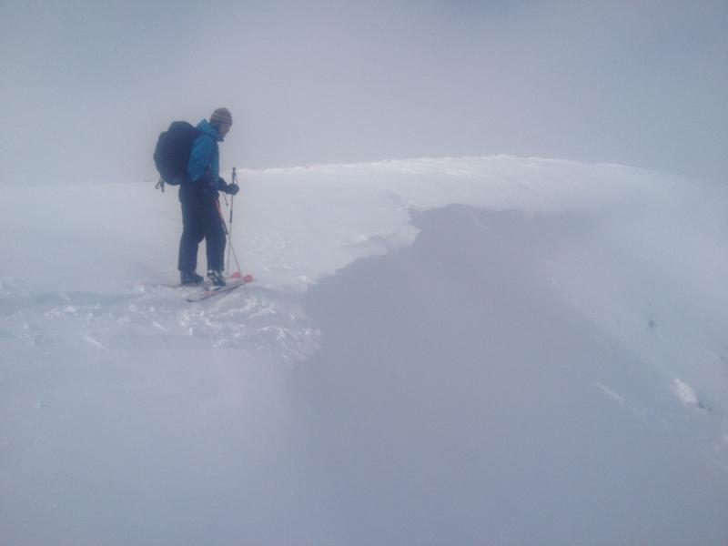
Braving arctic weather on the yet to be formed Big Cornice on Cornice Ridge 12-6-2013
A video observation from Garden City Bowls,12-4-2013.....HERE
|
 |
recent activity A party reported triggering a small wind slab avalanche yesterday in the Cornice Ridge Area above Tony Grove Lake. The same party reported localized collapsing and cracking in drifted upper elevation terrain, red flags indicating the existence of unstable snow. |
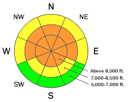
| type | aspect/elevation | characteristics |
|---|

|
|
LIKELIHOOD
 LIKELY
UNLIKELY
SIZE
 LARGE
SMALL
TREND
 INCREASING DANGER
SAME
DECREASING DANGER
|
|
description
South winds increased overnight and will continue today, creating dangerous avalanche conditions. Today's wind is plenty strong enough to rapidly drift the cold light snow that's currently on the snow surface. You'll find freshly formed and building wind slabs today in exposed terrain. These may become unmanageable as wind loading continues, but you certainly don't want to be caught and carried by any size avalanche anyway, with very shallow snow and sharp rocks in runout zones. Recent avalanches and shooting cracks will be the obvious red flags requiring you to reevaluate your route, but you should avoid steep drifted terrain today as a matter of course. |
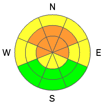
| type | aspect/elevation | characteristics |
|---|

|
|
LIKELIHOOD
LIKELY
UNLIKELY
SIZE
 LARGE
SMALL
TREND
INCREASING DANGER
SAME
DECREASING DANGER
|
|
description
Slabs on upper and mid-elevation slopes are building up thickness and weight on top of preexisting very weak sugary or faceted snow, which is widespread in the region due to the prolonged Thanksgiving high pressure system. The added weight from heavy snowfall and wind with today's storm is likely to overload the very weak underlying snow . Dangerous avalanche conditions already exist in drifted upper elevation terrain this morning, and today's storm could cause the danger to become much more widespread. You are likely to trigger dangerous avalanches if you venture into steep terrain, and persistent slab avalanches could be triggered remotely, from a distance, or worse from below.
|
 |
weather The National Weather Service in Salt Lake City has issued a Winter Storm Warning for our area through tomorrow afternoon. Expect light snowfall and gusty south winds this morning, with snowfall intensifying throughout the day and winds shifting around from the west and then northwest after frontal passage this evening. 6 to 10 inches of accumulation is forecast for the mountains around Logan today, with 3 to 7 additional tonight. Although a bit warmer than yesterday, it'll be frigid in the mountains again today, with a high temperature at 8500' forecast to be around 10 degrees and wind chills around negative 20. Temperatures will drop well below zero tonight, forecast calling for -7, and westerly winds will continue to sustain 20+ mph average speeds. Snowfall should start to tapper off tomorrow, leaving us in an arctic northwest flow with daytime highs not expected to rise above 0 degrees. The cold weather will stick with us well into next week, but a high pressure system will creep into the zone early in the week allowing temperatures to moderate in the mountains while trapping the cold in the valleys. Check out our one stop weather page........HERE |
| general announcements Sign up early for one of our life-saving avalanche classes.......HERE And refresh your avalanche knowledge, check out some of our tutorials........HERE Follow us at UAClogan on Twitter Utah Avalanche Center mobile app - Get your advisory on your iPhone along with great navigation and rescue tools. Discount lift tickets are now available at Backcountry.com - Thanks to Ski Utah and the Utah Resorts, including Beaver Mountain. All proceeds go towards paying for Utah Avalanche Center avalanche and mountain weather advisories. Benefit the Utah Avalanche Center when you shop from Backcountry.com or REI: Click this link for Backcountry.com or this link to REI, shop, and they will donate a percent of your purchase price to the UAC. Both offer free shipping (with some conditions) so this costs you nothing! Benefit the Utah Avalanche Center when you buy or sell on ebay - set the Utah Avalanche Center as a favorite non-profit in your ebay account here and click on ebay gives when you buy or sell. You can choose to have your seller fees donated to the UAC, which doesn't cost you a penny. Remember your information can save lives. If you see anything we should know about, please participate in the creation of our own community avalanche advisory by submitting snow and avalanche conditions. You can also call us at 801-524-5304 or 800-662-4140, email by clicking HERE, or include #utavy in your tweet or Instagram. I'll start issuing regular backcountry advisories on Monday, Wednesday, Friday, and Saturday mornings.... This advisory is produced by the U.S.D.A. Forest Service, which is solely responsible for its content. It describes only general avalanche conditions and local variations always exist. |


_1.jpg)