| During the month of April, Mark Miller will donate $75 to the charity of your choice (5 to chose from, including the Utah Avalanche Center!) Mark Miller Subaru has raised over $300k in the previous 6 Do Good Feel Good events. More Info here |  |
| During the month of April, Mark Miller will donate $75 to the charity of your choice (5 to chose from, including the Utah Avalanche Center!) Mark Miller Subaru has raised over $300k in the previous 6 Do Good Feel Good events. More Info here | |
| Advisory: Logan Area Mountains | Issued by Toby Weed for Friday - December 6, 2013 - 7:04am |
|---|


|
bottom line Heightened avalanche conditions exist and there's a MODERATE (or level 2) danger on drifted slopes at upper elevations. You could trigger persistent slab or fresh wind slab avalanches in steep drifted terrain. Being caught and carried in even a small avalanche could be very dangerous due to rocks in the runout. Very shallow and rocky early season snow conditions exist across the Logan Zone. Evaluate the snow and terrain carefully. A winter storm will create a rising avalanche danger in the backcountry this weekend.
|
 |
current conditions The fresh snow earlier in the week really helped snow conditions. We found smooth and nice shallow powder conditions yesterday south of Tony Grove Lake, but the snowpack is still quite shallow and rocky. In many areas in the zone, you sink to the ground through shallow, weak, and structureless faceted snow, and travel is difficult. The Tony Grove Snotel at 8400' reports 2 degrees below zero this morning, and there is 23 inches of total snow containing 69% of average water equivalent for the date. The 9700' Logan Peak weather station reports -9 degrees and light southwest wind, currently averaging a bit under 5 mph. The Tony Grove Road is not maintained for wheeled travel in the winter, and the road is currently very snowy, icy, and treacherous in places. We were able to drive up to the lake yesterday, but it was a bit dicey. A sled or 4-wheel-drive vehicles and chains are recommended. If you do ride up remember that there are lots of pedestrians sharing the road, and you have to watch your speed. Beaver Mountain allows uphill foot travel and usually appreciates the help packing in the shallow snow before opening..
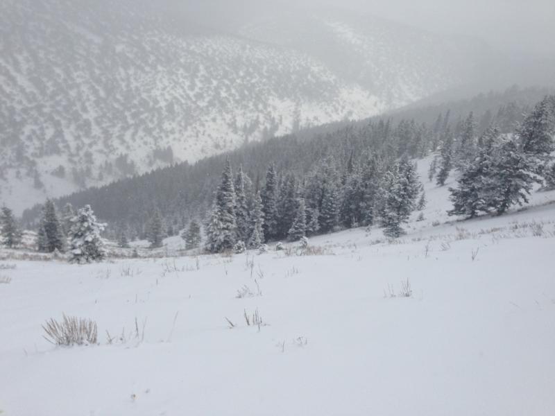
Looking down into the Garden City Bowls on 12-4-2013
A video observation from Garden City Bowls,12-4-2013.....HERE
|
 |
recent activity No significant avalanches were reported recently in the Logan Area. |
| type | aspect/elevation | characteristics |
|---|

|
|
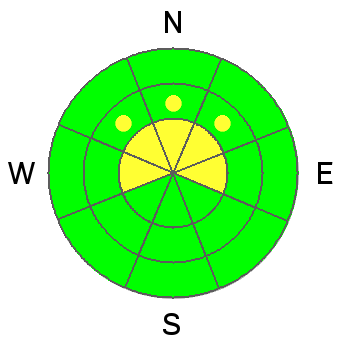
LIKELIHOOD
 LIKELY
UNLIKELY
SIZE
 LARGE
SMALL
TREND
 INCREASING DANGER
SAME
DECREASING DANGER
|
|
description
Slabs on some upper elevation slopes are building up thickness and weight on top of preexisting very weak sugary or faceted snow, which is widespread in the region due to the prolonged Thanksgiving high pressure system. Heightened avalanche conditions exist in drifted upper elevation terrain, and you might trigger avalanches in steep terrain remotely, from a distance, or below. |
| type | aspect/elevation | characteristics |
|---|

|
|
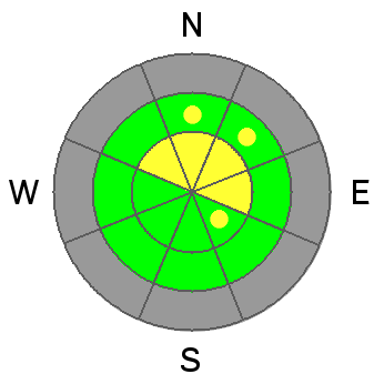
LIKELIHOOD
 LIKELY
UNLIKELY
SIZE
 LARGE
SMALL
TREND
INCREASING DANGER
SAME
DECREASING DANGER
|
|
description
Southwest winds will increase a little today, and they won't need to be very strong to drift the cold light snow currently on the snow surface. You'll find building and soft fresh wind slabs today, mainly in exposed upper elevation terrain. These should be fairly small and manageable, but you certainly don't want to be caught and carried by any size avalanche, with very shallow snow and sharp rocks in runout zones. |
 |
weather Expect very cold temperatures in the mountains again today, with local weather stations reading sub-zero again this morning, and a 8500' high temperature forecast at 6 degrees. Southwest wind will increase a bit by afternoon, and drifting of the cold light snow may well become a factor at upper elevations. This weekend's storm is looking promising, with snow likely beginning to accumulate tonight, and several more inches possible tomorrow, continuing into Sunday. A foot of accumulation by tomorrow night is a good possibility.... Expect cold and showery weather to continue into the first part of next week. Check out our one stop weather page........HERE |
| general announcements Sign up early for one of our life-saving avalanche classes.......HERE And refresh your avalanche knowledge, check out some of our tutorials........HERE Follow us at UAClogan on Twitter Utah Avalanche Center mobile app - Get your advisory on your iPhone along with great navigation and rescue tools. Discount lift tickets are now available at Backcountry.com - Thanks to Ski Utah and the Utah Resorts, including Beaver Mountain. All proceeds go towards paying for Utah Avalanche Center avalanche and mountain weather advisories. Benefit the Utah Avalanche Center when you shop from Backcountry.com or REI: Click this link for Backcountry.com or this link to REI, shop, and they will donate a percent of your purchase price to the UAC. Both offer free shipping (with some conditions) so this costs you nothing! Benefit the Utah Avalanche Center when you buy or sell on ebay - set the Utah Avalanche Center as a favorite non-profit in your ebay account here and click on ebay gives when you buy or sell. You can choose to have your seller fees donated to the UAC, which doesn't cost you a penny. Remember your information can save lives. If you see anything we should know about, please participate in the creation of our own community avalanche advisory by submitting snow and avalanche conditions. You can also call us at 801-524-5304 or 800-662-4140, email by clicking HERE, or include #utavy in your tweet or Instagram. I'll start issuing regular backcountry advisories on Monday, Wednesday, Friday, and Saturday mornings.... This advisory is produced by the U.S.D.A. Forest Service, which is solely responsible for its content. It describes only general avalanche conditions and local variations always exist. |


_1.jpg)