
| During the month of April, Mark Miller will donate $75 to the charity of your choice (5 to chose from, including the Utah Avalanche Center!) Mark Miller Subaru has raised over $300k in the previous 6 Do Good Feel Good events. More Info here |  |
| During the month of April, Mark Miller will donate $75 to the charity of your choice (5 to chose from, including the Utah Avalanche Center!) Mark Miller Subaru has raised over $300k in the previous 6 Do Good Feel Good events. More Info here | |
| Advisory: Logan Area Mountains | Issued by Toby Weed for Monday - December 2, 2013 - 6:37am |
|---|

|
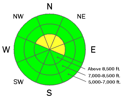
bottom line The snow is stable on most slopes and the danger is generally LOW ( or level 1) in the backcountry this morning. Expect a rising danger today, with sustained southwest wind and increasing snowfall, as a cold winter storm moves into the area. Heightened avalanche conditions and a MODERATE (or level 2) danger will develop on drifted slopes at upper elevations. You could trigger fresh and shallow wind slab avalanches in some steep terrain. Being caught and carried in even a small avalanche could be very dangerous due to rocks. Very shallow and rocky early season snow conditions exist across the Logan Zone. Evaluate the snow and terrain carefully.
|
 |
current conditions The Tony Grove Snotel at 8400' reports 3/10th of an inch of water in the past 24 hours, within a couple inches of fresh snow. It's 34 degrees this morning, and there is 18 inches of total snow containing 74% of average water equivalent for the date. The 9700' Logan Peak weather station reports 25 degrees and southwest wind averaging just under 30 mph, with a 51 mph gust earlier this morning The Tony Grove Road is not maintained for wheeled travel in the winter, and the road is currently icy and treacherous in places. 4-wheel-drive vehicles and chains are recommended. It's important to check and continue practicing with your avalanche rescue equipment.
|
 |
recent activity No avalanches were reported recently in the Logan Area. |
| type | aspect/elevation | characteristics |
|---|

|
|
LIKELIHOOD
 LIKELY
UNLIKELY
SIZE
 LARGE
SMALL
TREND
 INCREASING DANGER
SAME
DECREASING DANGER
|
|
description
With a little fresh snow and strong southwest winds overnight, shallow wind slabs are forming in exposed upper elevation terrain. These are likely to be fairly manageable this morning, but they'll grow throughout the day with continuing sustained west southwest winds and some snowfall this afternoon. Heightened avalanche conditions will develop on some drifted slopes at upper elevations this afternoon. |
 |
weather Snow is likely today, mainly afternoon, with 1 to 3 inches of accumulation possible by evening. High temperatures at 8500' will be around 34 degrees this morning, and sustained southwest and west winds will continue through the day. The strong cold front will swing through the zone in the early evening and we should expect a period of fairly heavy snowfall tonight, with 1 to 3 inches of accumulation forecast. Expect much colder temperatures tomorrow and continuing snowfall, with an additional 2 to 4 inches forecast.. More snow is expected tomorrow night, and a total of around an inch of water equivalent expected to accumulate by Wednesday. Unsettled and cold weather is expected to last through the work week. Check out our one stop weather page........HERE |
| general announcements Our annual "Pray for Snow" fundraiser/party will happen Thursday evening, December 5 at the Italian Place in downtown Logan, and you are invited. In addition to live tunes and good food, we've got lots of great deals on gear and services in our silent auction and raffles.... I hope to see you there. Sign up early for one of our life-saving avalanche classes.......HERE And refresh your avalanche knowledge, check out some of our tutorials........HERE Follow us at UAClogan on Twitter Benefit the Utah Avalanche Center when you shop from Backcountry.com or REI: Click this link for Backcountry.com or this link to REI, shop, and they will donate a percent of your purchase price to the UAC. Both offer free shipping (with some conditions) so this costs you nothing! Benefit the Utah Avalanche Center when you buy or sell on ebay - set the Utah Avalanche Center as a favorite non-profit in your ebay account here and click on ebay gives when you buy or sell. You can choose to have your seller fees donated to the UAC, which doesn't cost you a penny. Remember your information can save lives. If you see anything we should know about, please participate in the creation of our own community avalanche advisory by submitting snow and avalanche conditions. You can also call us at 801-524-5304 or 800-662-4140, email by clicking HERE, or include #utavy in your tweet or Instagram. I'll start issuing regular backcountry advisories on Monday, Wednesday, Friday, and Saturday mornings.... This advisory is produced by the U.S.D.A. Forest Service, which is solely responsible for its content. It describes only general avalanche conditions and local variations always exist. |


_1.jpg)