| During the month of April, Mark Miller will donate $75 to the charity of your choice (5 to chose from, including the Utah Avalanche Center!) Mark Miller Subaru has raised over $300k in the previous 6 Do Good Feel Good events. More Info here |  |
| During the month of April, Mark Miller will donate $75 to the charity of your choice (5 to chose from, including the Utah Avalanche Center!) Mark Miller Subaru has raised over $300k in the previous 6 Do Good Feel Good events. More Info here | |
| Advisory: Logan Area Mountains | Issued by Toby Weed for Friday - November 29, 2013 - 6:46am |
|---|

|
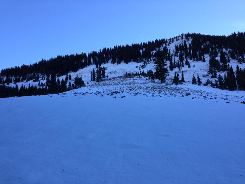
bottom line The snow is stable on most slopes and the danger is generally LOW ( or level 1) in the backcountry. Avalanches are unlikely, but exceptions exist on drifted slopes at upper elevations, and there are pockets with a MODERATE (level 2) danger. Being caught and carried in even a small avalanche could be very dangerous due to rocks. Very shallow and rocky early season snow conditions exist across the Logan Zone. Evaluate the snow and terrain carefully.
|
 |
current conditions We really need a little snow to freshen up the highly variable snow conditions in the backcountry, and I am hopeful that we will get a good dump early next week. It's always nice to get out into the backcountry, but you won't find much powder this weekend. It is possible to ride or glide on some upper elevation roadways and smooth meadows, and you can find areas with soft, re-crystallized snow, but very shallow, early season and wind wrecked snow conditions exist across the region. The Tony Grove Snotel at 8400' reports 32 degrees this morning, and there is 17 inches of total snow containing 76% of average water equivalent for the date. The Tony Grove Road is not maintained for wheeled travel in the winter, and the road is currently icy and treacherous in places. 4-wheel-drive vehicles and chains are recommended. It's important to check and continue practicing with your avalanche rescue equipment.
|
 |
recent activity No avalanches were reported recently in the Logan Area. |
| type | aspect/elevation | characteristics |
|---|

|
|
LIKELIHOOD
 LIKELY
UNLIKELY
SIZE
 LARGE
SMALL
TREND
 INCREASING DANGER
SAME
DECREASING DANGER
|
|
description
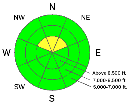
Hard wind slab avalanches 1 to 2 feet deep, releasing on sugary or faceted old snow are unlikely yet still possible in some areas today, especially on very steep upper elevation slopes The shallow old snow from the Halloween storms remained on upper elevation north facing slopes, and it is very weak and faceted.. You might trigger an old hard wind slab avalanche on a steep drifted slope today, especially in a very steep terrain feature like a gully or scoop that has weak sugary snow as a basal layer.
|
 |
weather It'll be mostly sunny and warm again today, with mountain high temperatures in the 40's and light west wind. We might see some high clouds tomorrow and it'll be a little cooler. We'll see increasing clouds a perhaps a few snow showers in the mountains on Sunday, but don't count on much in the way of accumulation. The strong and very cold winter storm still looks to be on track for early next week and will begin to affect the Logan Area on Monday, with heavy snowfall likely holding off until Monday night and Tuesday. Significant snowfall with a serious winter storm looks to be likely. Check out our one stop weather page........HERE |
| general announcements Our annual "Pray for Snow" fundraiser/party will happen the evening of December 5 at the Italian Place in downtown Logan, and you are invited, so save the date. Sign up early for one of our life-saving avalanche classes.......HERE And refresh your avalanche knowledge, check out some of our tutorials........HERE Follow us at UAClogan on Twitter I'll start issuing regular backcountry advisories in December. |


_1.jpg)