| During the month of April, Mark Miller will donate $75 to the charity of your choice (5 to chose from, including the Utah Avalanche Center!) Mark Miller Subaru has raised over $300k in the previous 6 Do Good Feel Good events. More Info here |  |
| During the month of April, Mark Miller will donate $75 to the charity of your choice (5 to chose from, including the Utah Avalanche Center!) Mark Miller Subaru has raised over $300k in the previous 6 Do Good Feel Good events. More Info here | |
| Advisory: Logan Area Mountains | Issued by Toby Weed for Saturday - November 23, 2013 - 6:12am |
|---|

|
bottom line Heightened avalanche conditions exist and there is a MODERATE (or level 2) danger on drifted slopes at upper elevations in the backcountry. You could trigger dangerous hard wind slab avalanches on steep slopes and in unusual or unexpected locations this weekend, . Pockets with a CONSIDERABLE (or level 3) danger might be found at upper elevations on smooth north facing slopes with preexisting weak snow, and dangerous triggered avalanches are likely in some areas. Careful snowpack evaluation, cautious routefinding, and conservative decision making will be essential today, and you should continue to avoid steep and especially drifted slopes at upper elevations.
|
 |
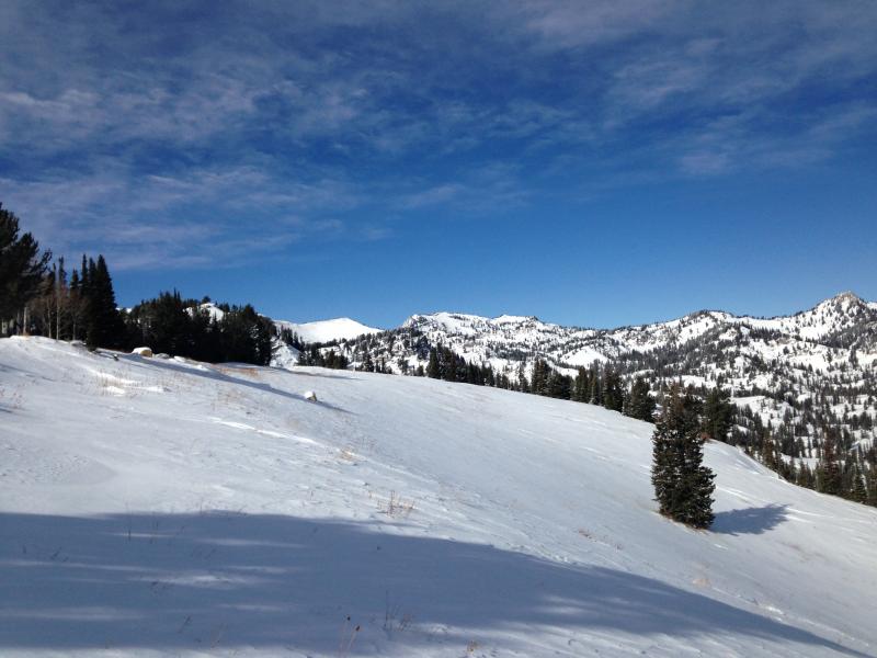
current conditions Strong east winds continue to strip snow off exposed upper elevation slopes, while creating drifts and wind slabs in unusual places. The Logan Peak weather station at 9700' reports 16 degrees and sustained east winds for at least the last 36 hours, currently averaging close to 60 mph, with a 78 mph gust earlier this morning. Tony Grove Snotel at 8400' reports 22 degrees, and 20 inches of total snow containing 4.2 inches of water equivalent, 96% of average water content for the date. You'll find nice soft snow on a shallow supportable base in sheltered terrain and a moonscape of sastrugi, rock hard drifts of varying depths, and slopes stripped bare of snow. Very shallow, early season snow conditions exist. The Tony Grove Road is not maintained for wheeled travel in the winter, and the road is currently somewhat treacherous. 4-wheel-drive vehicles and chains are recommended. It's important to check your avalanche rescue equipment, change to fresh batteries in your beacon, and test it's range. Refresh yourself and your partners with easy companion rescue scenarios, and continue practicing in the early season. History shows that early avalanches are not uncommon in the area, and you need to start the winter season on top of your game.
Check out Paige's video observation from 11-22-2013 in the Tony Grove Area.......HERE
|
 |
recent activity Observers reported a couple small natural wind slab avalanches and loose sluffs in steep terrain in the Tony Grove Lake Area yesterday. Otherwise, no significant avalanches have yet been reported in the backcountry around Logan, but several parties in the past week reported triggering audible collapses and shooting cracks indicating unstable snow conditions on upper elevation slopes. |
| type | aspect/elevation | characteristics |
|---|

|
|
LIKELIHOOD
 LIKELY
UNLIKELY
SIZE
 LARGE
SMALL
TREND
 INCREASING DANGER
SAME
DECREASING DANGER
|
|
description
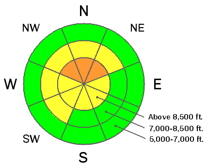
Sustained and very strong east wind scoured snow from exposed terrain and drifted it into lee slope avalanche stating zones and other terrain influenced deposition areas. Sustained east winds are somewhat unusual, as our prevailing winds are from the west, so we'll find hard wind slabs in some unusual or unexpected areas this weekend. You could trigger a dangerous wind slab avalanche on a steep drifted slope today, especially in a terrain feature like a gully or scoop that has old faceted snow as a basal layer. Hard wind slabs also likely formed around sub-ridges, timber stringers, and cliffs or rock outcroppings. Hard slabs have a nasty habit of allowing you to get well out on them before releasing. Keep in mind that with shallow early season snow cover and sharp rocks everywhere, a ride in even a small avalanche will be fairly dangerous.
|
| type | aspect/elevation | characteristics |
|---|

|

|
LIKELIHOOD
 LIKELY
UNLIKELY
SIZE
LARGE
SMALL
TREND
INCREASING DANGER
SAME
DECREASING DANGER
|
|
description
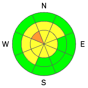
The shallow old snow from the Halloween storms remained on upper elevation north facing slopes, and it has become very weak and faceted.. Last weekend's storm created a nice slab overloading this preexisting weak snow, and several additional inches of heavy snow accumulated at upper elevations through the week. Drifting from strong east winds in the past couple days may have put some slopes into a fragile balance and close to the tipping point. Triggered persistent slab avalanches 1 to 2 feet deep, releasing on the sugary old snow are probable in some areas today, especially on drifted smooth upper elevation slopes. Persistent slab avalanches could be triggered remotely, from a distance, or worse from below. Reassess your route in the case of obvious signs of instability like fresh avalanche activity, cracking within the new snow, or audible collapsing. |
 |
weather Strong east winds will continue today, only gradually decreasing this afternoon, but we should see plenty of sun and warming temperatures, with a high at 8500' forecast to be around 34 degrees. Mountain low temperatures will drop to around 21 degrees overnight and the east wind will further diminish. It looks like nice weather for Sunday, with a daytime high temperature around 34 degrees, light wind and plenty of sun. A high pressure system will gain control and fair weather in the mountains will continue well into next week.... Check out our one stop weather page........HERE |
| general announcements Our annual "Pray for Snow" fundraiser/party is scheduled for the evening of December 5 at the Italian Place in downtown Logan, and you are invited, so save the date. Sign up early for one of our life-saving avalanche classes.......HERE And refresh your avalanche knowledge, check out some of our tutorials........HERE Follow us at UAClogan on Twitter I'll start issuing regular backcountry advisories in December. |


_1.jpg)