| During the month of April, Mark Miller will donate $75 to the charity of your choice (5 to chose from, including the Utah Avalanche Center!) Mark Miller Subaru has raised over $300k in the previous 6 Do Good Feel Good events. More Info here |  |
| During the month of April, Mark Miller will donate $75 to the charity of your choice (5 to chose from, including the Utah Avalanche Center!) Mark Miller Subaru has raised over $300k in the previous 6 Do Good Feel Good events. More Info here | |
| Advisory: Logan Area Mountains | Issued by Toby Weed for Thursday - November 21, 2013 - 6:57am |
|---|


|
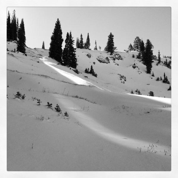
bottom line Heightened avalanche conditions exist at upper elevations in the backcountry, and you could trigger persistent slab or wind slab avalanches on steep slopes. Pockets with dangerous avalanche conditions and a CONSIDERABLE (or level 3) danger will be found at upper elevations on smooth north facing slopes with preexisting weak snow, and triggered avalanches are likely in some steep terrain. The danger of triggering a fresh wind slab avalanche will rise throughout the day and will be MODERATE ( or level 2) on all upper elevation slopes. Careful snowpack evaluation, cautious routefinding, and conservative decision making will be essential today, and you should continue to avoid steep and especially drifted slopes at upper elevations. Very shallow, early season snow conditions exist.
|
 |
current conditions Tony Grove Snotel at 8400' reports a couple more inches of new snow overnight, over a half inch of water in the last 48 hours, and a temperature of 28 degrees early this morning. There is 21 inches of total snow containing 4.2 inches of water equivalent, amazingly now up to 103% of average water content for the date. It's only 21 degrees up at the 9700' Logan Peak weather station, and I'm reading light northerly winds this morning. The UDOT Hwy 89 Logan Summit weather station reports east winds up to around 15 mph. The Tony Grove Road is not maintained for wheeled travel in the winter, and the road is mostly packed with snow and ice with a few inches of heavy new snow up high. Even so, lots of people were successful in driving 4-wheel-drive vehicles up to the parking lot at the lake in the last several days.
It's important to check your avalanche rescue equipment, change to fresh batteries in your beacon, and test it's range. Refresh yourself and your partners with easy companion rescue scenarios, and continue practicing in the early season. History shows that early avalanches are not uncommon in the area, and you need to start the winter season on top of your game. Check out my video observation from 11-18-2013 in the Tony Grove Area.......HERE
|
 |
recent activity No avalanches have yet been reported recently in the backcountry around Logan, but several parties recently reported triggering audible collapses and shooting cracks indicating unstable snow conditions on upper elevation slopes. |
| type | aspect/elevation | characteristics |
|---|

|

|
LIKELIHOOD
 LIKELY
UNLIKELY
SIZE
 LARGE
SMALL
TREND
 INCREASING DANGER
SAME
DECREASING DANGER
|
|
description
The shallow old snow from the Halloween storms remained on upper elevation north facing slopes, and it has become very weak and faceted.. The weekend storm created a nice slab overloading this preexisting weak snow, and several additional inches of heavy snow accumulated at upper elevations in the last couple days. Triggered slab avalanches 1 to 2 feet deep, releasing on the sugary old snow are probable in some areas today, especially on smooth upper elevation slopes. Persistent slab avalanches could be triggered remotely, from a distance, or worse from below. Reassess your route in the case of obvious signs of instability like fresh avalanche activity, cracking within the new snow, or audible collapsing.
|
| type | aspect/elevation | characteristics |
|---|

|
|
LIKELIHOOD
 LIKELY
UNLIKELY
SIZE
 LARGE
SMALL
TREND
 INCREASING DANGER
SAME
DECREASING DANGER
|
|
description
Increasing east wind is forecast for today with average wind speeds rising above 20 mph in the afternoon and increasing further tonight. Although east winds will blow uphill on our most suspect slopes it'll find plenty of fresh snow to drift ,and I expect wind slabs will form at upper elevations throughout the day today. You could trigger a wind slab avalanche on a steep drifted slope today, especially in a terrain feature like a gully or scoop that has old faceted snow as a basal layer. Wind slabs are also likely to form around sub-ridges and rock outcroppings, and they might be found in somewhat unusual or unexpected areas. Keep in mind that with shallow early season snow cover and sharp rocks everywhere, a ride in even a small avalanche will be fairly dangerous. |
 |
weather Expect snow this morning to taper off, with clearing and perhaps a bit of sun this afternoon. Temperatures will drop during the day to below 20 degrees this afternoon. East winds will gradually increase today and reach average wind speeds in the upper twenties tonight. East winds will remain fairly strong tomorrow, but we should see plenty of sun and warming temperatures, with a high at 8500' forecast to be around 30 degrees. It looks like nice weather for the weekend, with daytime highs a few degrees above freezing and mostly clear skies. Fair weather will continue well into next week. Check out our one stop weather page........HERE |
| general announcements Our annual "Pray for Snow" fundraiser/party is scheduled for the evening of December 5 at the Italian Place in downtown Logan, and you are invited, so save the date. Sign up early for one of our life-saving avalanche classes.......HERE And refresh your avalanche knowledge, check out some of our tutorials........HERE Follow us at UAClogan on Twitter Stay tuned for my early season intermittent updates, and I'll start issuing regular backcountry advisories as soon as there is enough snow for you to get out on. |


_1.jpg)