
| During the month of April, Mark Miller will donate $75 to the charity of your choice (5 to chose from, including the Utah Avalanche Center!) Mark Miller Subaru has raised over $300k in the previous 6 Do Good Feel Good events. More Info here |  |
| During the month of April, Mark Miller will donate $75 to the charity of your choice (5 to chose from, including the Utah Avalanche Center!) Mark Miller Subaru has raised over $300k in the previous 6 Do Good Feel Good events. More Info here | |
| Advisory: Logan Area Mountains | Issued by Toby Weed for Sunday - November 17, 2013 - 6:40am |
|---|

|
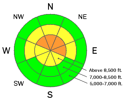
bottom line Heavy snowfall and sustained southwest and west winds with yesterday's storm created dangerous avalanche conditions at upper elevations in the backcountry. The danger is CONSIDERABLE (or level 3) at upper elevations on slopes facing the northern half of the compass. Triggered wind slab and persistent slab avalanches are probable in steep upper elevation terrain and are most likely on smooth slopes with preexisting weak snow. Careful snowpack evaluation, cautious routefinding, and conservative decision making will be essential today, and you should avoid steep and especially drifted slopes at upper elevations.
|
 |
current conditions Yesterday's storm was quite productive for the Bear River Range. The Tony Grove Snotel now reports 21 inches of total snow with 3.3 inches of water equivalent, amazingly back up to 100% of normal water content for the date. The Snotel reports around a foot-and-a-half of new snow yesterday (compressed down to 12 inches on the total snow stake) with 1.8 inches of water in the last 24 hours and 2.3 in the last 48. It's 20 degrees up at 8400' and 13 up at the 9700' Logan Peak weather station where sustained southwest and west wind blew all day long yesterday, averaging in the mid twenties with a recorded gust in excess of 60 mph yesterday evening. It was also very windy yesterday in Logan Canyon, with sustained average wind speeds of around 40 mph and gusts of 55 recorded at the hwy 89 Logan Summit weather station. Expect a cold and breezy day in the mountains today with a forecast wind chill of -1 degree. The Tony Grove Road is not maintained for wheeled travel in the winter, and yesterday's storm likely made the drive a bit tricky. It's a good time to check your avalanche rescue equipment, change to fresh batteries in your beacon, and test it's range. Refresh yourself and your partners with easy companion rescue scenarios in the early season. History shows that early season avalanches are not uncommon in the area, and you might as well start the winter season on top of your game.
|
 |
recent activity No avalanches have yet been reported in the backcountry around Logan, but a few naturals probably occurred overnight at upper elevations. |
| type | aspect/elevation | characteristics |
|---|

|
|
LIKELIHOOD
 LIKELY
UNLIKELY
SIZE
 LARGE
SMALL
TREND
 INCREASING DANGER
SAME
DECREASING DANGER
|
|
description
Sustained and strong southwest and west winds drifted lots of snow into upper elevation avalanche starting zones, creating fresh stiff and probably sensitive wind slabs. You could trigger a one to two-foot-deep wind slab avalanche on a steep drifted slope today, especially in a terrain feature like a gully or scoop that has old faceted snow as a basal layer. Keep in mind that with shallow early season snow cover and sharp rocks everywhere, a ride in even a small avalanche will be fairly dangerous this weekend. |
| type | aspect/elevation | characteristics |
|---|

|
|
LIKELIHOOD
LIKELY
UNLIKELY
SIZE
LARGE
SMALL
TREND
INCREASING DANGER
SAME
DECREASING DANGER
|
|
description
The shallow old snow from the Halloween storms remained on upper elevation north facing slopes, and it has become very weak and faceted.. Yesterday's storm created a nice slab overloading the preexisting weak snow. Triggered slab avalanches releasing on the sugary old snow are likely today, especially on smooth upper elevation slopes. Persistent slab avalanches could be triggered remotely, from a distance, or worse from below. Watch for and reassess your route in the case of obvious signs of instability like fresh avalanche activity, cracking within the new snow, or audible collapsing. |
 |
weather It'll be breezy and cold in the mountains today, and snow showers should taper off in the morning. Expect wind chills around -1 degree, sustained west winds above 20 mph on exposed ridge lines, and high temperatures at 8500' of around 23 degrees. It'll be partly cloudy tonight with low temperatures in the upper teens. Expect mostly fair weather on Monday, with high temperatures in the mid thirties, becoming unsettled again Tuesday and through the remainder of the work week. Check out our one stop weather page........HERE |
| general announcements Our annual "Pray for Snow" fundraiser/party is scheduled for the evening of December 5 at the Italian Place in downtown Logan, and you are invited, so save the date. Sign up early for one of our life-saving avalanche classes.......HERE And refresh your avalanche knowledge, check out some of our tutorials........HERE Follow us at UAClogan on Twitter Stay tuned for my early season intermittent updates, and I'll start issuing regular backcountry advisories as soon as there is enough snow for you to get out on. |


_1.jpg)
