

Avalanche Advisory
| Advisory: Logan Area Mountains | Issued by Toby Weed for March 25, 2013 - 6:40am |
|---|


Above 8,500 ft.
7,000-8,500 ft.
5,000-7,000 ft.
|
bottom line Although the danger is LOW on most slopes this morning, areas with heightened avalanche conditions exist in the backcountry, and there's still a MODERATE (or level 2) danger on drifted slopes at upper elevations. You might trigger 1 to 2 foot deep wind slab avalanches on steep slopes with recent deposits of drifted snow, and ridge-top cornices might break further back than expected, potentially triggering wind slab avalanches on slopes below. Midday solar warming will create heightened avalanche conditions and a rising danger of loose wet and heat related avalanches on slopes with saturated surface snow. Evaluate the snow and terrain carefully, and continue to follow safe travel protocols...
|

 |
special announcement Beaver Mountain is staying open through the end of the month and conditions are great! Go to http://www.backcountry.com/utah-avalanche-center to get tickets for Beaver Mountain. You won't save a ton of money, but all proceeds from sales of these tickets will benefit the Utah Avalanche Center, and It's super easy to do.
|
 |
current conditions Cold temperatures and cloud cover over the weekend kept the snow nice and fluffy on most slopes. Conditions are good at all elevations, but there is significantly more new snow up high. The Tony Grove Snotel at 8400' reports 8 degrees, and with 65"of total snow, the station sits at 66% of average water for the date. The CSI Logan Peak weather station at 9700' reports a chilly 5 degrees and it looks like the wind sensor is encased in rime. The UDOT Hwy 89 Logan Summit station reports light easterly winds, a bit of new snow, and 5 degrees below zero at 6:00 this morning. |
 |
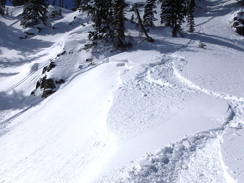
recent activity We received reports of several triggered wind slab avalanches over the weekend in the Tony Grove and Providence Canyon areas. The shallow soft slab avalanches, involving fresh snow from last week, were fairly small and manageable, and nobody got caught... Here's a link to our updated Avalanche List.
|
Avalanche Problem 1over the next 24 hours
| type | aspect/elevation | characteristics |
|---|
 |


Above 8,500 ft.
7,000-8,500 ft.
5,000-7,000 ft.
|
|
|
description
You might trigger wind slab avalanches on steep drifted slopes. Sustained and gusty westerly winds late last week drifted fresh snow into lee slopes and deposition areas and created heightened avalanche conditions at upper elevations. Watch for and avoid smooth, stiffer, chalky-looking, and sometimes hollow sounding drifts on steep slopes. You'll probably find fresh drifts in and around terrain features like sub-ridges, cliff bands, or gullies. Beware the recently enlarged ridge-top cornices, which are likely to break a further back than expected and could take you for a surprise ride... Cornice falls could be fairly large in terrain exposed to drifting, and they could trigger wind slab avalanches on steep drifted slopes below. |

Avalanche Problem 2over the next 24 hours
| type | aspect/elevation | characteristics |
|---|
 |


Above 8,500 ft.
7,000-8,500 ft.
5,000-7,000 ft.
|
|
|
description
Despite single digit mountain temperatures this morning, the springtime sun angle is high enough that solar warming is likely to cause the fresh surface snow to become saturated and prone to sluffing or heat related avalanching in sunny terrain. Pin wheels or roller balls are signs that the surface snow is heating up, and you should avoid travel on or under steep slopes with saturated surface snow. As always, watch for terrain traps like trees or gullies below you. |

 |
weather Expect mostly sunny skies, light southwest winds, and 9000' high temperatures of around 30 degrees today. I'll be mostly cloudy tonight with a moderate south wind and mountain temperatures dropping a bit below twenty degrees. Expect cloudy and mild conditions tomorrow, with 9000' temperatures in the upper 30s, a moderate south wind, and a chance for a little snow in the afternoon. A bit of snow is also possible Tuesday night and Wednesday, but accumulations won't amount to much, with less than an inch forecast for each 12 hour period. A high pressure system will build into the region later in the week. Check out the Logan Mountain Weather page...
|
| general annoucements For a printer friendly version of this advisory click HERE Remember your information from the backcountry can save lives. If you see or trigger an avalanche, or see anything else we should know about, please send us your snow and avalanche observations. You can also call us at 801-524-5304 or email by clicking HERE. In the Logan Area you can contact Toby Weed directly at 435-757-7578. I will update this advisory on Monday, Wednesday, Friday, and Saturday mornings by around 7:30... This advisory is produced by the U.S.D.A. Forest Service, which is solely responsible for its content. It describes only general avalanche conditions and local variations always exist. |