

Avalanche Advisory
| Advisory: Logan Area Mountains | Issued by Toby Weed for March 22, 2013 - 6:59am |
|---|


Above 8,500 ft.
7,000-8,500 ft.
5,000-7,000 ft.
|
bottom line Heightened avalanche conditions exist, and there's a MODERATE (level 2) danger on drifted slopes at mid and upper elevations. You might trigger 1 to 2-foot-deep wind slab avalanches on steep slopes with recent deposits of drifted snow. The danger is LOW at lower elevations, in sheltered areas, and in lower angle terrain. Evaluate the snow and terrain carefully, especially in drifted upper elevation terrain.
|

 |
special announcement Go to http://www.backcountry.com/utah-avalanche-center to get tickets for Beaver Mountain. You won't save a ton of money, but all proceeds from sales of these tickets will benefit the Utah Avalanche Center, and It's super easy to do. Ever stop to wonder what life in Utah would be like without non-profit organizations? No Park City trails, community gardens, shelters for homeless people or pets, programs for kids in need, environmental advocacy groups, or avalanche centers? Sounds grim. All these groups exist because people like you value them enough to pay for them. If you value these services, please show your support. Please go to http://loveutgiveut.razoo.com/giving_events/utah13/home on Friday to learn more about how you benefit from these services and how you can help them. |
 |
current conditions We found very nice smooth and fast shallow powder conditions yesterday, best in lower angled terrain. Conditions are fairly good at all elevations, but there is significantly more new snow up high. The Tony Grove Snotel at 8400' reports several more inches of accumulation and around 1" of water equivalent in the last 48 hours. It's 14 degrees, and with 64"of total snow, the station sits at 67% of average water for the date. The CSI Logan Peak weather station at 9700' reports a chilly 6 degrees and light northwest wind. Overnight hourly average wind speeds diminished into the single digits, but westerly winds are forecast to intensify again and more snow is likely today.
|
 |
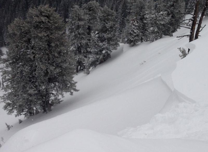
recent activity There were lots of small natural wind slab and cornice-fall avalanches at upper elevations yesterday, and we were easily able to trigger manageable wind slabs in the upper Richard's Hollow Area by knocking small chunks of cornice onto drifted slopes. These fresh soft slabs were around a foot deep and 60 or 70 feet wide, and they ran quickly a good ways down into the bowl below... Here's a link to our updated Avalanche List.
|
Avalanche Problem 1over the next 24 hours
| type | aspect/elevation | characteristics |
|---|
 |
Above 8,500 ft.
7,000-8,500 ft.
5,000-7,000 ft.
|
|
|
description
Sustained and gusty westerly winds in the past couple days drifted fresh snow into lee slopes and deposition areas at upper elevations. The winds diminished overnight, but are supposed to resume again today. Watch for and avoid smooth, stiffer, chalky-looking, and sometimes hollow sounding drifts on steep slopes. You might find fresh drifts in and around terrain features like sub-ridges, cliff bands, or gullies. Accumulations of new snow and continued westerly winds created heightened avalanche conditions at upper elevations today, and you might trigger wind slab avalanches on steep drifted slopes. These might be a bit less manageable today than they were yesterday... |

 |
weather It'll be colder today, with highs in the lower twenties, sustained west-southwest winds, and 3 to 5 inches of additional snow possible. Unsettled and cold weather is expected to persist through the weekend. Snow showers will continue tonight, 1 or 2 inches of accumulation is possible, mountain temperatures will drop into the single digits, and westerly winds will continue. Snow is likely tomorrow, with 1 to 2 inches of accumulation forecast, sub-twenty degree temperatures in the mountains, and continued west-northwest winds. Snow showers and fairly cold wintry weather under the westerly flow will continue through the weekend and into early next week. Check out the Logan Mountain Weather page...
|
| general annoucements For a printer friendly version of this advisory click HERE Remember your information from the backcountry can save lives. If you see or trigger an avalanche, or see anything else we should know about, please send us your snow and avalanche observations. You can also call us at 801-524-5304 or email by clicking HERE. In the Logan Area you can contact Toby Weed directly at 435-757-7578. I will update this advisory on Monday, Wednesday, Friday, and Saturday mornings by around 7:30... This advisory is produced by the U.S.D.A. Forest Service, which is solely responsible for its content. It describes only general avalanche conditions and local variations always exist. |