

Avalanche Advisory
| Advisory: Logan Area Mountains | Issued by Toby Weed for March 16, 2013 - 6:35am |
|---|


Above 8,500 ft.
7,000-8,500 ft.
5,000-7,000 ft.
|
bottom line Very warm mountain temperatures are causing dangerous avalanche conditions, and the danger will rise with the heat to CONSIDERABLE (or level 3) again in the backcountry today. After another unseasonably warm night, wet and heat-related avalanches will become increasingly likely as the day warms and the already saturated snow softens. Natural avalanches are possible in steep terrain at all elevations.. Avoid and stay out from under steep slopes and obvious or historic avalanche paths. Careful snowpack evaluation, cautious route-finding, and conservative decision-making will be essential for travel in avalanche terrain today.
|

 |
special announcement Go to http://www.backcountry.com/utah-avalanche-center to get tickets for Beaver Mountain. You won't save a ton of money, but all proceeds from sales of these tickets will benefit the Utah Avalanche Center, and It's super easy to do. |
 |
current conditions You'll find fairly poor riding conditions, once the snow softens up (which will probably be a bit earlier again today), and the danger of wet avalanches will rise with the temperatures again in the backcountry,. The Tony Grove Snotel at 8400' reports 35 degrees, and with 54"of total snow, the station sits at 64% of average water for the date. The CSI Logan Peak weather station at 9700' reports a cool 26 degrees and northwest winds averaging in the mid teens.
|
 |
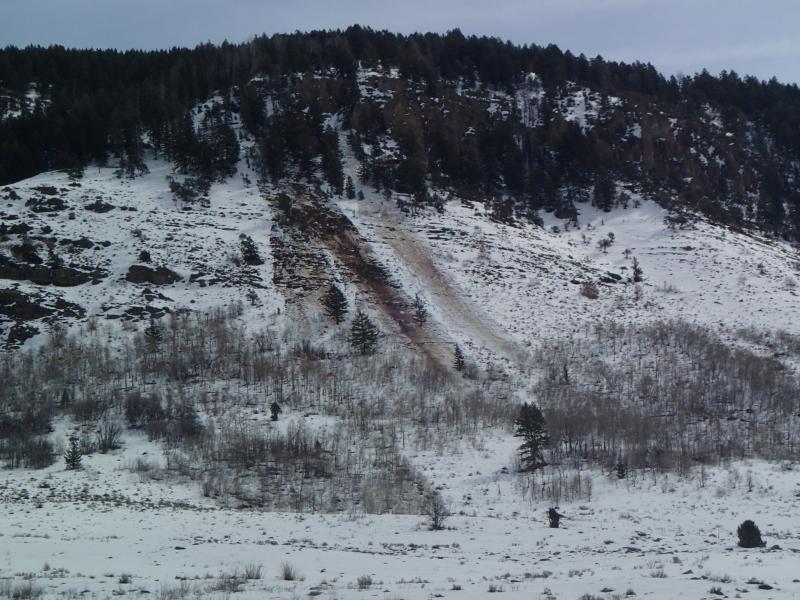
recent activity Looked like hot wax melting off the mountains by yesterday afternoon, with numerous natural wet avalanches observed across the Logan Zone in the past couple days. Of note is a good sized wet slab reportedly across Beaver Canyon from the Beaver Backside runs, which luckily stopped in thick timber before spilling out onto the highway. I noticed an impressive dirty wet natural avalanche (probably from Wednesday evening) across from Red Banks Campground in Logan Canyon, and Amy and Eric Flygare's photo from yesterday shows additional activity on the same slope.. Here's a link to our updated Avalanche List.
|
Avalanche Problem 1over the next 10 hours
| type | aspect/elevation | characteristics |
|---|
 |
Above 8,500 ft.
7,000-8,500 ft.
5,000-7,000 ft.
|
|
|
description
Cloud cover may help to keep the lid on the warming today, but overnight low temperatures, although a bit cooler than on Thursday night, stayed well above freezing at most local remote weather stations. Wet and heat-related avalanches will become likely once again as the day warms and the saturated snow softens up after a superficial overnight surface refreeze. Avoid steep terrain with warmth softened and saturated snow today, watch for potential terrain traps below steep slopes, and plan on an early departure from the backcountry due to rapidly warming conditions. In addition to the expected loose wet activity, here are a couple other issues to consider:
Evelyn recently published an interesting blog about wet avalanches......HERE
|

 |
weather Expect mostly sunny skies, with a northwest breeze and 9000' high temperatures of around 40 degrees, which is a little cooler than it's been in the last couple days.. Temperatures should drop into the mid twenties tonight with mostly cloudy skies, increasing southwest winds and a chance of snow after midnight.. We should see snow and lots of wind Sunday, with 2 to 4 inches of accumulation forecast and sustained strong northwesterly winds, with gusts on the ridges in the mid fifties. High pressure conditions will return early next week. Check out the Logan Mountain Weather page...
|
| general annoucements Want to ski all night long? And raise some funds for the UAC? By yourself or with your friends. 12 Hours of Canyons...Friday March 29th-30th. 7pm-7am. 12 hours of Canyons info...... HERE For a printer friendly version of this advisory click HERE Remember your information from the backcountry can save lives. If you see or trigger an avalanche, or see anything else we should know about, please send us your snow and avalanche observations. You can also call us at 801-524-5304 or email by clicking HERE. In the Logan Area you can contact Toby Weed directly at 435-757-7578. I will update this advisory on Monday, Wednesday, Friday, and Saturday mornings by around 7:30... This advisory is produced by the U.S.D.A. Forest Service, which is solely responsible for its content. It describes only general avalanche conditions and local variations always exist. |