

Avalanche Advisory
| Advisory: Logan Area Mountains | Issued by Toby Weed for March 14, 2013 - 6:26am |
|---|


Above 8,500 ft.
7,000-8,500 ft.
5,000-7,000 ft.
|
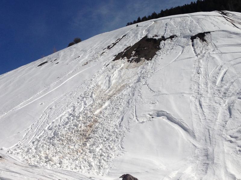
bottom line Rapidly rising and very warm mountain temperatures will create dangerous avalanche conditions and a CONSIDERABLE (or level 3) danger in the backcountry today. Wet and heat related avalanches will become increasingly likely as the day warms and the already saturated snow softens. Natural avalanches are possible in steep terrain at all elevations.. Avoid and stay out from under steep slopes and obvious or historic avalanche paths. Careful snowpack evaluation, cautious route-finding, and conservative decision-making will be essential for travel in avalanche terrain today.
|

 |
special announcement Go to http://www.backcountry.com/utah-avalanche-center to get tickets for Beaver Mountain. You won't save a ton of money, but all proceeds from sales of these tickets will benefit the Utah Avalanche Center, and It's super easy to do. |
 |
current conditions The Tony Grove Snotel at 8400' reports 36 degrees, and with 57"of total snow, the station sits at 66% of average water for the date. The CSI Logan Peak weather station at 9700' also reports 36 degrees and southwest winds in the teens. You'll find fairly poor riding conditions and increasingly dangerous avalanche conditions in the backcountry today, and it certainly isn't a good day for mountaineering.
|
 |
recent activity A few large natural wet avalanches were reported from the Wasatch Range yesterday, from the mountains above Ogden, Salt Lake, and Provo . Locally; a rider triggered a small wet slab avalanche on a west facing tailings pile Tuesday at the quarry in lower Providence Canyon, and observers yesterday witnessed some rather small natural activity in Wood Camp Hollow. Otherwise no avalanches were reported recently in the Logan Zone Here's a link to our updated Avalanche List.
|
Avalanche Problem 1over the next 10 hours
| type | aspect/elevation | characteristics |
|---|
 |


Above 8,500 ft.
7,000-8,500 ft.
5,000-7,000 ft.
|
|
|
description
The forecast high temperature of 55 degrees for 9000' will be around 10 degrees warmer than yesterday and 20 degrees warmer than Tuesday, and overnight lows stayed a few degrees above freezing at many local remote mountain weather stations. Wet and heat-related avalanches will become likely as the day warms and as the saturated snow on sunny slopes and at lower and mid elevations softens up. Avoid steep terrain with warmth softened and saturated snow today, watch for potential terrain traps below steep slopes, and plan on an early departure from the backcountry due to rapidly warming conditions..... Evelyn published an interesting blog about wet avalanches yesterday......HERE
|

Avalanche Problem 2over the next 24 hours
| type | aspect/elevation | characteristics |
|---|
 |


Above 8,500 ft.
7,000-8,500 ft.
5,000-7,000 ft.
|
|
|
description
Be aware that today's rapid warming will also cause a general increase in avalanche danger...
|
 |
weather Expect mostly sunny skies, with a southwest breeze and 9000' high temperatures of around 55 degrees! Temperatures should drop to around freezing tonight with partly cloudy skies. Expect warm conditions again tomorrow in the mountains, with partly cloudy skies, a westerly breeze, and 9000' temperatures forecast at 49 degrees... We'll see some clouds by Friday night and perhaps a few snow showers, more importantly, a few degrees cooler temperatures. There is a chance for a little snow over the weekend, with an inch or two of accumulation Saturday night and Sunday, and clouds will likely cool things down a bit..... Check out the Logan Mountain Weather page...
|
| general annoucements Want to ski all night long? And raise some funds for the UAC? By yourself or with your friends. 12 Hours of Canyons...Friday March 29th-30th. 7pm-7am. 12 hours of Canyons info...... HERE For a printer friendly version of this advisory click HERE Remember your information from the backcountry can save lives. If you see or trigger an avalanche, or see anything else we should know about, please send us your snow and avalanche observations. You can also call us at 801-524-5304 or email by clicking HERE. In the Logan Area you can contact Toby Weed directly at 435-757-7578. I will update this advisory on Monday, Wednesday, Friday, and Saturday mornings by around 7:30... This advisory is produced by the U.S.D.A. Forest Service, which is solely responsible for its content. It describes only general avalanche conditions and local variations always exist. |