Home
utahavalanchecenter.org
Keeping you on top!

Sponsor Ads

  • About
    • Submit Avalanche Observations
    • Contact
    • Who we are
    • Staff
    • FUAC
    • How we generate an advisory
    • Log in
  • Advisories
    • Logan
    • Ogden
    • Salt Lake
    • Provo
    • Uintas
    • Skyline
    • Moab
    • Tomorrow's Danger Rating
    • Podcasts
    • Archives
  • Education
    • Classes/Workshops
    • Know Before You Go
    • Tutorials
    • Beacon Practice
    • Avalanche Stats
    • FAQ
    • Encyclopedia
  • Detailed Info
    • Submit Backcountry Observations
    • All the Good Stuff
      • All Regions
      • Logan
      • Ogden
      • Salt Lake
      • Provo
      • Uintas
      • Skyline
      • Moab
    • Avalanches
      • All Regions
      • Logan
      • Ogden
      • Salt Lake
      • Provo
      • Skyline
      • Uintas
      • Moab
      • Detailed List
    • Accidents
    • Video
    • Photos
      • Avalanches
    • Maps
      • Selected Routes
      • Place Names Map
    • Archives
  • Blog
  • Weather
    • Mtn Weather Forecasts
      • Logan
      • Moab
      • Salt Lake
    • 48hr Weather Charts
      • Temps-Wind-Precip
      • Precipitation
    • Seasonal Weather Charts
      • Current Season
      • Alta Monthly Snowfall
      • Archives
    • Radar Loops
      • Salt Lake Regional
      • US Composite
  • Resources
    • Essential Gear
    • Smartphone Apps
    • Beacon Tech
    • Beacon Practice
    • Books & Videos
    • Guide Services
    • Wasatch Backcountry Rescue
    • Local Mtn Info
    • Place Names Map
  • Events
    • List View
    • Calendar View
      • September
      • October
      • November
      • December
      • January
      • February
      • March
      • April
  • Store
    • Online Store
    • Online Store Help
  • Sponsors
  • Donate
Avalanche Advisory
Tweet
Advisory: Logan Area Mountains Issued by Toby Weed for March 12, 2013 - 5:06pm
Above 8,500 ft.
7,000-8,500 ft.
5,000-7,000 ft.
bottom line

Generally stable snow conditions exist, and the danger is mostly LOW (level 1) in the backcountry this morning. There are some exceptions, and you might find pockets with heightened avalanche conditions and a MODERATE (or level 2) danger in some places.

  • Dangerous persistent slab avalanches are unlikely but possible in isolated outlying terrain with poor snow structure.
  • Drifting occurred overnight and west-northwest winds are increasing this morning, so you could trigger shallow wind slab avalanches or cornice falls in drifted upper elevation terrain.
  • Seasonal warmth will again soften the saturated lower elevation snow and increase the danger of wet avalanches in steep terrain.

Use normal caution, evaluate the snow and terrain carefully, and continue to avoid steep drifted slopes and areas with soft and saturated snow.


danger scale: 1. Low 2. Moderate 3. Considerable 4. High 5. Extreme
special announcement

Go to http://www.backcountry.com/utah-avalanche-center to get tickets for Beaver Mountain. You won't save a ton of money, but all proceeds from sales of these tickets will benefit the Utah Avalanche Center, and It's super easy to do.

current conditions

The Tony Grove Snotel at 8400' reports 28 degrees, and with 60" of total snow, the station sits at 63% of average water for the date. The CSI Logan Peak weather station at 9700' reports 20 degrees and west-northwest winds picked up overnight and are averaging in the mid twenties with gust of 37 mph early this morning. You can still find fairly nice dry snow on north facing slopes at upper elevations, but elsewhere sun and warm temperatures created crusty or soggy snow conditions....

recent activity

No new avalanches were reported or observed in the Logan Area over the weekend..

Here's a link to our updated Avalanche List.

Avalanche Problem 1over the next 24 hours
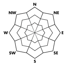
type aspect/elevation characteristics
Above 8,500 ft.
7,000-8,500 ft.
5,000-7,000 ft.
likelihood size
likely
unlikely
large
small
distribution trend
widespread
isolated
More Dangerous
Same
Less Dangerous
description

The danger is Low this morning in most areas, but Low doesn't mean No danger, and you still might trigger avalanches on very steep slopes or in rather exceptional terrain. You still need to use good backcountry travel protocols

  • Isolated persistent slab avalanches up to around 2 feet deep, failing on weak sugary faceted snow are possible in outlying areas with shallow and poor snow structure. The added weight from this week's drifted snow or seasonal warming might be enough to activate buried dormant weak layers in some areas, and although rather unlikely, dangerous triggered avalanches are still a possibility. I've recently found poor snow structure mostly in shallow mid-elevation terrain, and it's worse in the eastern and northern reaches of the Logan Zone.
  • You should continue to avoid steep drifted slopes. Increasing west-northwest winds overnight and continuing today probably built wind slabs in upper elevation lee terrain. In some cases these could be sensitive to your weight. Watch for and avoid stiffer wind deposited snow on the lee side of major ridges and in and around terrain features like sub-ridges, cliff bands, and steep walled gullies. Ridge top cornices might break further back than expected, and cornice falls could trigger more dangerous slab avalanches on steep slopes below.
  • The danger of wet avalanches will increase with midday warming at lower elevations and on any steep slope with soft saturated snow.
Avalanche Problem 2over the next 24 hours
type aspect/elevation characteristics
Above 8,500 ft.
7,000-8,500 ft.
5,000-7,000 ft.
likelihood size
likely
unlikely
large
small
distribution trend
widespread
isolated
More Dangerous
Increasing
Less Dangerous
description

Rapid warming is creating heightened wet avalanche conditions at lower and mid elevations in the backcountry.

weather

A little snow is possible this afternoon, but temperatures will be fairly warm and not much in the way of accumulation is expected. Expect mostly cloudy skies, mountain high temperatures in the upper 30s and a westerly breeze. Snow showers are possible tonight, but again accumulations will be rather light, with moderate west winds and low temperatures in the mid twenties. Snow showers are possible again tomorrow morning, and the sun may come out for a while in the afternoon. High temperatures will climb into the lower 40s and the moderate winds will be from the west-southwest. It looks like mountain temperatures will continue to gradually climb each day this week and could ascend into the 50+ range on Thursday.

Check out the Logan Mountain Weather page...

general annoucements

For a printer friendly version of this advisory click HERE

Remember your information from the backcountry can save lives. If you see or trigger an avalanche, or see anything else we should know about, please send us your snow and avalanche observations.   You can also call us at 801-524-5304 or email by clicking HERE.  In the Logan Area you can contact Toby Weed directly at 435-757-7578.

I will update this advisory on Monday, Wednesday, Friday, and Saturday mornings by around 7:30...

This advisory is produced by the U.S.D.A. Forest Service, which is solely responsible for its content. It describes only general avalanche conditions and local variations always exist. 

Tweet

2242 West North Temple | Salt Lake City, UT 84116 | (801) 524-5304 | Advisory Hotline: (888) 999-4019 | Contact

Powered by Drupal