

| Advisory: Logan Area Mountains | Issued by Toby Weed for January 21, 2013 - 8:23am |
|---|


Above 8,500 ft.
7,000-8,500 ft.
5,000-7,000 ft.
|
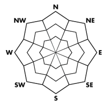
bottom line The snow is mostly stable, and there is a LOW (level 1) danger in the backcountry today. Avalanches are generally unlikely, yet possible on isolated steep slopes at all elevations. You might trigger hard persistent slabs on previously drifted slopes, where stiff wind slabs formed on top of weak sugary faceted snow. Loose wet avalanches are possible on sun-warmed slopes and generally manageable triggered loose dry sluffs are likely on very steep shady slopes with shallow weak snow lacking cohesion. Use normal caution and continue to use safe travel protocols.
|
 |
current conditions The Tony Grove Snotel at 8400' reports 25 degrees this morning, there is 44 inches of total snow, and 63% of average water content for the date. The 9700' CSI Logan Peak weather station reports 23 degrees and west-northwest winds averaging around 20 mph. Better head up to the mountains to escape the freezing smog. You'll find clean air, much warmer temperatures, and plenty of sunshine. Snow conditions are quite varied these days, with nice fast re-crystallized snow in sheltered shady areas, best at mid-elevations, and sun-crusts, wind-jack, rime-crusts, and shallow structureless snow elsewhere.
|
 |
recent activity No new avalanches were reported locally since the storm last Friday. (1-11) Here's a link to our updated avalanche list...
|
| type | aspect/elevation | characteristics |
|---|
 |


Above 8,500 ft.
7,000-8,500 ft.
5,000-7,000 ft.
|
|
|
description
Old wind slabs around a foot deep are unlikely in most areas, but still possible at all elevations on drifted slopes. Drifts formed on weak sugary faceted surface snow, in many areas capped by a rime-crust. The snow is especially weak at lower and mid elevations and where the snowpack is generally shallow, but. in most areas a slab layer consisting of harder snow above the weakness is lacking. Watch out for old wind slabs on the lee side of major ridges and in and around terrain features like cliff bands, sub-ridges, gullies, and scoops. Avoid stiff drifts on steep slopes, which often appear smooth or rounded and chalky looking, and they sometimes sound rather hollow. Stiff hard slabs might allow you to get out on them before releasing. Cracking and audible collapsing are red flags.
|
| type | aspect/elevation | characteristics |
|---|
 |


Above 8,500 ft.
7,000-8,500 ft.
5,000-7,000 ft.
|
|
|
description
Loose wet avalanches are possible on steep sun-warmed slopes in the midday heat. Loose dry sluffs are also possible on some steep sheltered slopes with loose re-crystallized or faceted snow. Avoid potential terrain traps like gullies or trees below steep slopes. Remember that although unlikely, avalanches are still possible with a LOW danger rating. You still need to carry your beacon, probe,and shovel and practice safe travel protocols. Only one person at a time while traveling across steep slopes while the rest of the party watches from a safer location.... Avalanches might occur on steep slopes at low elevations or in rather unexpected locations....
|
 |
weather Expect sunny skies and warm temperatures in the mountains today. High temperatures will reach the upper 30s at 9000', and we'll feel a moderate northwesterly breeze. A strong high pressure system will remain over the region. The nasty temperature inversion will persist and cold air and smog will continue to be trapped in the valleys well into the work week. We'll find fair weather in the mountains during this time. A weakening disturbance will graze Northern Utah Wednesday night and Thursday, which might bring us a bit of relief from the smog, and a little snow is possible. The high pressure system will rebuild on Friday, but a change in the weather pattern looks to be in the works, with relief from the smog likely next weekend and hopefully a stormy pattern developing by next week. Check out the new Logan Mountain Weather page...
|
| general annoucements Remember your information from the backcountry can save lives. If you see or trigger an avalanche, or see anything else we should know about, please send us your snow and avalanche observations. You can also call us at 801-524-5304 or email by clicking HERE. In the Logan Area you can contact Toby Weed directly at 435-757-7578. I will update this advisory on Monday, Wednesday, Friday, and Saturday mornings by around 7:30... This advisory is produced by the U.S.D.A. Forest Service, which is solely responsible for its content. It describes only general avalanche conditions and local variations always exist. |