

| Advisory: Logan Area Mountains | Issued by Toby Weed for December 14, 2012 - 7:49am |
|---|


Above 8,500 ft.
7,000-8,500 ft.
5,000-7,000 ft.
|
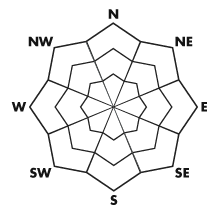
bottom line There is a MODERATE danger in the backcountry, and you could trigger wind slab avalanches on drifted upper elevation elevation slopes. There are also localized areas with poor snow structure and the potential for larger more dangerous triggered persistent slab avalanches. Evaluate the snow and terrain carefully , and make conservative decisions regarding your route selection, especially in drifted terrain at upper elevations. The snow is fairly stable and the danger is generally LOW in sheltered terrain, below around 8000' in elevation, and on slopes less steep than about 35 degrees..
|
 |
current conditions We've been finding some very good powder riding conditions in the backcountry this week Many slopes are now covered enough for skiing or boarding, while sledding is still somewhat limited to smooth, relatively rock-free meadows and upper elevation roadways. The Tony Grove Snotel reports 35 inches of total snow, 80% of normal for the date, and it's 22 degrees at 8400' this morning. The wind is from the southeast averaging in the upper twenties and gusting around 40 mph on Logan Peak, and it's 21 degrees at Campbell Scientific's 9700' mountain top weather station. The Tony Grove Road is not maintained for wheeled travel in the winter, and conditions are always changing. Be sure you are prepared with shovels and other emergency supplies if you attempt the drive.
|
 |
recent activity No avalanches were reported recently in the Logan Zone |
| type | aspect/elevation | characteristics |
|---|
 |


Above 8,500 ft.
7,000-8,500 ft.
5,000-7,000 ft.
|
|
|
description
There are localized areas with poor snow structure where you could trigger dangerous persistent slab avalanches. This has been a big issue In the Central Wasatch Range, where several broad and scary avalanches were triggered this week. The avalanches are failing on buried weak layers consisting of sugary or faceted snow near or sandwiched between thin rain crusts from early December, and are around 2 feet deep... Pay close attention to red flags like audible collapsing and cracking, and avoid steep drifted slopes. The most suspect slopes are at upper elevations and facing northwest through east. |
| type | aspect/elevation | characteristics |
|---|
 |


Above 8,500 ft.
7,000-8,500 ft.
5,000-7,000 ft.
|
|
|
description
You could trigger wind slab avalanches if you venture into steep drifted terrain at upper elevations. Stiff wind slabs formed on the lee side of major ridgelines and in and around terrain features like gullies, scoops, sub-ridges, cliff bands, and rock outcroppings.. Fresh wind slabs formed overnight and will continue to build today with sustained winds coming out of a slightly different southeast direction. Avoid smooth, chalky looking, and hollow sounding drifts on steep slopes... Stiff wind slabs have the nasty tenancy to let people get out on them before releasing.... |
 |
weather It looks like we're moving into an active weather pattern, and avalanche conditions across the state are likely to get interesting in the next few days. A pacific storm will move northward through mainly southern Utah today, and a little snow is also possible up north. Winds will be out of the southeast this morning, and switch around from the west by evening. Mountain temperatures will hover around freezing today. Snow is likely tonight. with 2 to 4 inches of accumulation forecast and northwesterly wind. Snow will continue through the weekend, with 3 to 5 inches possible tomorrow and an additional foot or more possible on Sunday... It looks like the productive and stormy weather will continue well into next week. Check out the Logan Mountain Weather page...
|
| general annoucements Discount lift tickets are in! Go to http://www.backcountry.com/ Deals on donated gear to benefit the UAC: Check out the Ebay charity auction w/ splitboards from Chimera, Never Summer, & Voile, skis from BD, Mtn Approach folding ski/pack kit, a Pieps beacon, Gecko Skins, Scarpa AT boots, & Fritschi brakes. CLICK HERE!! Remember your information can save lives. If you see anything we should know about, please participate in the creation of our own community avalanche advisory by submitting snow and avalanche conditions. You can also call us at 801-524-5304 or email by clicking HERE. In the Logan Area you can contact Toby Weed directly at 435-757-7578. This advisory is produced by the U.S. Forest Service, which is solely responsible for its content. It describes only general avalanche conditions and local variations always exist. |