

Forecast for the Uintas Area Mountains

Issued by Craig Gordon on
Sunday morning, December 11, 2022
Sunday morning, December 11, 2022
Heads up... a solid looking storm clobbers our zone, changes the landscape, and avalanche danger will begin ramping up as the storm evolves-
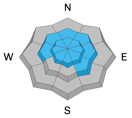
For today, you'll find CONSIDERABLE avalanche danger in mid and upper elevation terrain, especially on slopes facing the north half of the compass in the wind zone at and above treeline. Human triggered avalanches breaking to weak, sugary, midpack snow are LIKELY. Lower elevation shady slopes with similar layering offer MODERATE avalanche danger and human triggered avalanches are POSSIBLE.
LOW avalanche danger is found on low and mid elevation south facing slopes and human triggered avalanches are UNLIKELY.
Wanna avoid avalanche danger, score great riding, and stay out of the wind? Well then, you came to the right place. Here's the hot tip... I've been finding excellent riding conditions and fun meadow skipping on mellow, wind sheltered slopes with no overhead hazard (meaning, no steep slopes above or adjacent to where I'm traveling). Remember, don't get too throttle happy because it's still low tide and there's plenty of reef barely hidden underneath our recent storms. With a significant danger of hitting rocks, stumps, and other obstacles, you'll wanna tone it down today and don't let a buried treasure ruin your season.
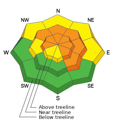
Low
Moderate
Considerable
High
Extreme
Learn how to read the forecast here
Special Avalanche Bulletin
STRONG SOUTHERLY WINDS, COUPLED WITH DENSE, HEAVY SNOW WILL MAKE THE AVALANCHE DANGER RISE OVER THE NEXT 24 HRS, POTENTIALLY REACHING HIGH AVALANCHE DANGER BY THIS EVENING. LARGE, DANGEROUS AVALANCHES BECOME MORE LIKELY AS THE STORM MATERIALIZES. AVOID BEING ON, UNDER, OR ADJACENT TO STEEP WIND DRIFTED SLOPES AND TERRAIN STEEPER THAN 30 DEGREES.
 Special Announcements
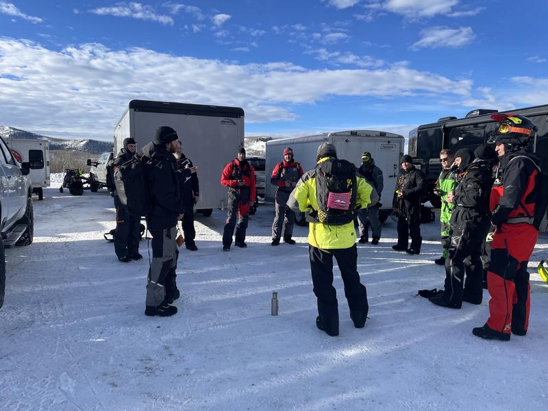
Andy Nassetta preaching the Avalanche Gospel whilst briefing yesterday's Sled 101 class with current conditions and avy hazard as they collectively formulate a plan for the day. What an honor it was to join this crew and a pleasure to watch the high degree of avy awareness our UAC education team brings to the table. As always, world class delivery served up by Joey Manship, Micheal Davis, and of course, master forecaster.... Andy Nassetta... solid work men!
The Utah Avalanche Center and the Division of Outdoor Recreation celebrate the Fourth Annual Avalanche Awareness week, from December 4 - December 11. Click HERE to view the full list of events for the week.
Mirror Lake Highway is closed for the season. SR-35 (Wolf Creek Pass) remains open.
 Weather and Snow
Nowcast- The warm before the storm settled into the region overnight with thickening clouds and temperatures rising into the mid 20's and low 30's. Southerly winds ramped up late Saturday and continue howling into the 50's and 60's along the ridges. With a mostly solid base and remarkable coverage, riding and turning conditions remain quite good. However, recent winds worked the big open bowls and with breezy conditions on tap for today, you'll wanna consider seeking out mid elevation, wind sheltered terrain for the best snow quality.
Forecast- Look for cloudy skies and temperatures rising into the 30's, as cow-tipping winds blast into the 60's and 70's near the high peaks. Snow develops late in the day and it should start stomping right around dinnertime.
Futurecast- A couple inches of snow stacks up late today with a solid slug of moisture overnight delivering a foot of snow as the cold front arrives. A break in the action is slated for early Monday with another shot of cold, dry snow redeveloping around midday Monday. Storm totals in the 12"-16" range with over an inch of H2O seems resonable.
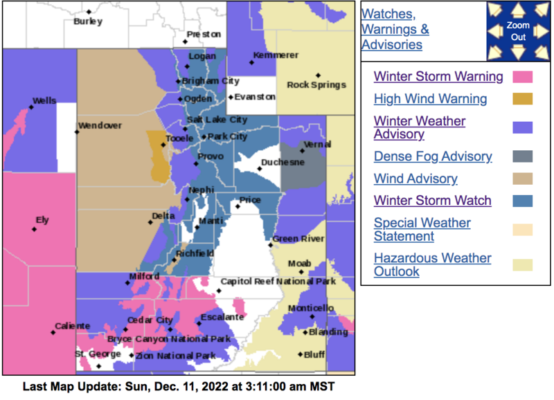
Now that's the kind of weather map we like to see. A multi-day storm keeps snow flying through early next week.
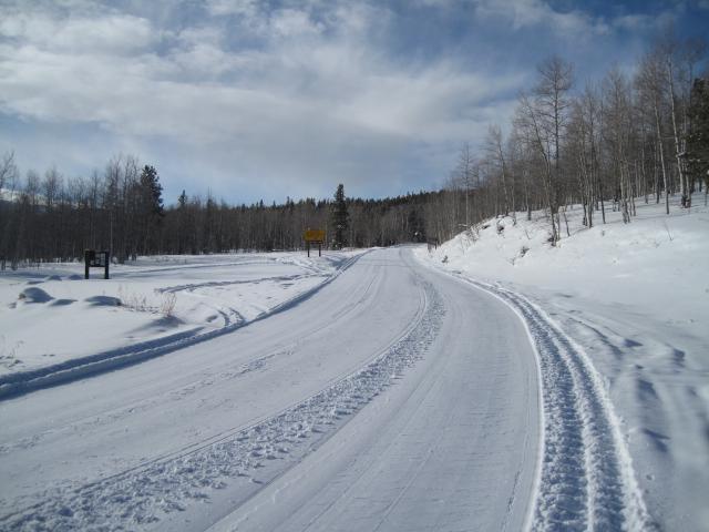
Ted reports great riding conditions and smooth sailing on fresh 'roy in the Whitney Basin.
Lots of excellent trip reports and recent obs are found HERE.
 Recent Avalanches
No recent avy activity to report, but a slew of Uinta obs are HERE.

Avalanche Problem #1
Persistent Weak Layer
Type
Location
Likelihood
Size
Description
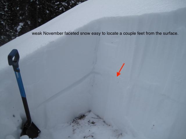
Ted was near Gold Hill yesterday and finds the very apparent mid November faceted snow layer, buried in the mid portion of our snowpack. More on Ted's travels HERE.
The sugary, weak faceted snow buried in the mid portion of our snowpack was just getting comfortable in its own skin, adjusting to last weeks big storm, and the lack of recent avalanche activity suggested a slow turn towards stability... good news. But today's big wind, coupled with forecasted additional water weight and storm snow is gonna reactivate our mid pack weak layers and bring 'em back to life. Problem is... strong snow rests on weaker snow, giving us a false sense of snow stability, luring us well out onto steep slopes before they break above us and the whole roof crashes down. So yes, I'm thinking not only about the snow I'm riding in, but also the snow I'm riding on. Here's where the rubber hits the road and what makes things tricky right now... any avalanche that fails near our problem child, the persistent weak layer or (PWL), is gonna break deep and wide and it's gonna be dangerous.
Unless you take your shovel out, dig down and investigate a bit, you can easily get lulled into a false sense of snow stability because the snowpack has gained a substantial amount of buoyancy and will feel strong and solid underneath or skis, board, or sled.
Obvious signs of unstable snow include cracking, collapsing, and whoomping noises as well as natures freebie... natural avalanches!
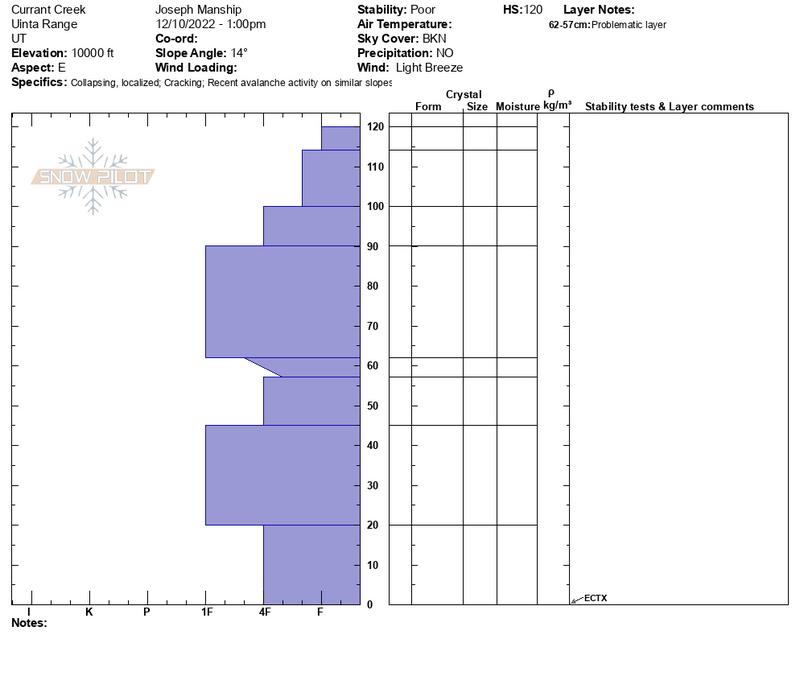
We taught a Sled 101 class yesterday in the Currant Creek zone and found similar structure on the south half of the range.
Avalanche Problem #2
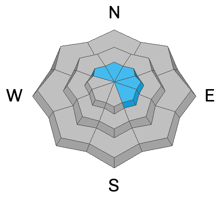
Wind Drifted Snow
Type
Location
Likelihood
Size
Description
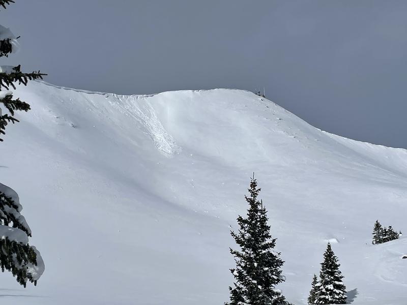
As winds increased Saturday, a piece of cornice initiated this shallow wind drift on a steep, leeward slope near Currant Creek Peak.
Yesterday's wind drifts were shallow, predictable, and straight-forward. But overnight, landscape changing winds cranked, producing fresh drifts that are gonna be more widespread and more sensitive to our additional weight. And once initiated, this big brother version carries the possibility of snow breaking deeper and wider than we might expect. Found mostly on the leeward side of upper elevation ridges, I'd also be on the look out for drifting around terrain features like chutes and gullies. In either case, you'll wanna look for and avoid any fat looking rounded pillow of snow, especially if it sounds hollow like a drum.
Easily managed and avoided with terrain choices, lose the wind, you lose the problem and score great riding conditions to boot.
Additional Information
And... we were super busy this summer upgrading the western Uinta weather station network and this real-time winter info is found HERE (click weather stations, and then on the Western Uinta tab)
Your observations are important, so please let me know what you're seeing... click HERE and contribute to this amazing community-based program
General Announcements
Issued at 03:57 on Sunday December 11th, this forecast expires 24 hours after the date and time posted, but will be updated by 07:00 Monday December 12th.
Before it gets too crazy, now is the time to book an avalanche awareness presentation for your group, club, or posse. You can reach Craig directly at 801-231-2170 or [email protected].
This forecast is from the U.S.D.A. Forest Service, which is solely responsible for its content. This forecast describes general avalanche conditions and local variations always occur.