

Forecast for the Uintas Area Mountains

Issued by Craig Gordon on
Monday morning, December 12, 2022
Monday morning, December 12, 2022
Don't get fooled into thinking we're only dealing with new snow slides. Yesterday's strong winds reshaped the landscape, creating deceptively dangerous avalanche conditions-
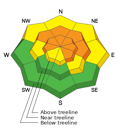
Today, you'll continue finding CONSIDERABLE avalanche danger in mid and upper elevation terrain, especially on slopes facing the north half of the compass in the wind zone at and above treeline. Human triggered avalanches breaking to weak, sugary, midpack snow are LIKELY. Lower elevation shady slopes with similar layering offer MODERATE avalanche danger and human triggered avalanches are POSSIBLE.
LOW avalanche danger is found on low and mid elevation south facing slopes and human triggered avalanches are UNLIKELY.
Wind sheltered terrain with no overhead hazard (meaning, no steep slopes above or adjacent to where I'm traveling) is the hot ticket. I've been finding excellent riding conditions and fun meadow skipping on mellow, wind sheltered slopes with no overhead hazard . Remember, don't get too throttle happy because it's still low tide and there's plenty of reef barely hidden underneath our recent storms. With a significant danger of hitting rocks, stumps, and other obstacles, you'll wanna tone it down today and don't let a buried treasure ruin your season.
Low
Moderate
Considerable
High
Extreme
Learn how to read the forecast here
 Special Announcements
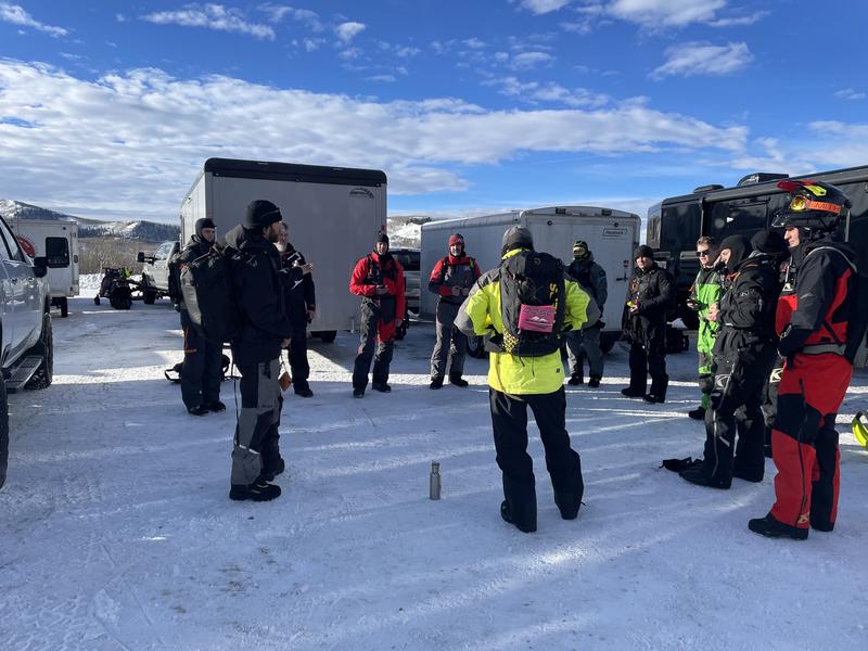
Andy Nassetta preaching the Avalanche Gospel whilst briefing Saturday's Sled 101 class with current conditions and avy hazard as they collectively formulate a plan for the day. What an honor it was to join this crew and a pleasure to watch the high degree of avy awareness our UAC education team brings to the table. As always, world class delivery served up by Joey Manship, Micheal Davis, and of course, master forecaster.... Andy Nassetta... solid work men!
Mirror Lake Highway is closed for the season. SR-35 (Wolf Creek Pass) remains open.
 Weather and Snow
Nowcast- Last nights storm was a bit of a bust for the eastern front, delivering just 4" of snow to most locations, with barely .30" H2O. (meaning it's low density snow). But, don't let your heart be troubled... a backdoor sneak to the Mirror Lake zone stacked up nearly 8" of snow. Ridgetop battering southerly winds finally tapered off at the start of the new day, and currently blow 15-25 mph along the high peaks. Riding and turning conditions are quite good, though recent winds worked the big open bowls, so today you'll wanna consider seeking out mid elevation, wind sheltered terrain for the best snow quality.
Forecast- Look for cloudy skies with a few scattered snow showers, though additional accumulations will be nominal at best. Winds shift to the west and decrease as the day wares on. Temperatures don't change much from where we're at this morning and dip into the single digits overnight.
Futurecast- Unsettled weather with small increments of additional snow expected for Tuesday and Wednesday. Partly cloudy skies are on tap to round out the work week.
Lots of excellent trip reports and recent obs are found HERE.
 Recent Avalanches
No recent avy activity to report, but a slew of Uinta obs are HERE.

Avalanche Problem #1
Persistent Weak Layer
Type
Location
Likelihood
Size
Description
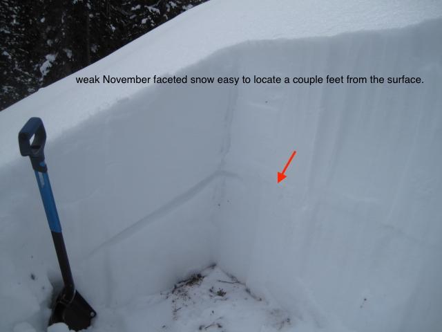
Ted was near Gold Hill Saturday and easily locates the very apparent mid November faceted snow layer, buried in the mid portion of our snowpack. More on Ted's travels HERE.
Good news-
Prior to Sunday nights storm, weak, sugary faceted snow buried in the mid portion of our snowpack was just getting comfortable in its own skin, adjusting to last weeks big storm, and the lack of recent avalanche activity suggested a slow turn towards stability... good news.
Bad news-
48 hours worth of strong southerly winds not only changed the landscape, they also added an additional layer of strong snow to our pre-existing snowpack. Problem is... all that strong snow rests on weaker, midpack snow (our problem child, the persistent weak layer or PWL) which formed during the mid November drought.
Troubling news-
Strong snow resting on weaker snow gives us a false sense of snow stability, because it feels solid and bomber underneath our skis, board, or sled. In fact, this combo often lures us well out onto steep slopes before weak layers fail, allowing avalanches to break well above us and the whole roof crashes down. So yes, I'm thinking not only about the snow I'm riding in, but also the snow I'm riding on. Here's where the rubber hits the road and what makes things tricky right now... any avalanche that fails near the midpack PWL , is gonna break deep and wide and it's gonna be dangerous.
Unless you take your shovel out, dig down and investigate a bit, you can easily get lulled into a false sense of snow stability because the snowpack has gained a substantial amount of buoyancy and will feel strong and solid underneath or skis, board, or sled.
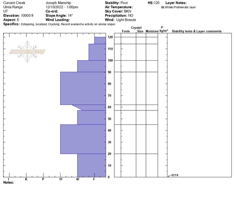
We taught a Sled 101 class Saturday in the Currant Creek zone and found similar structure on the south half of the range.
Avalanche Problem #2
Wind Drifted Snow
Type
Location
Likelihood
Size
Description
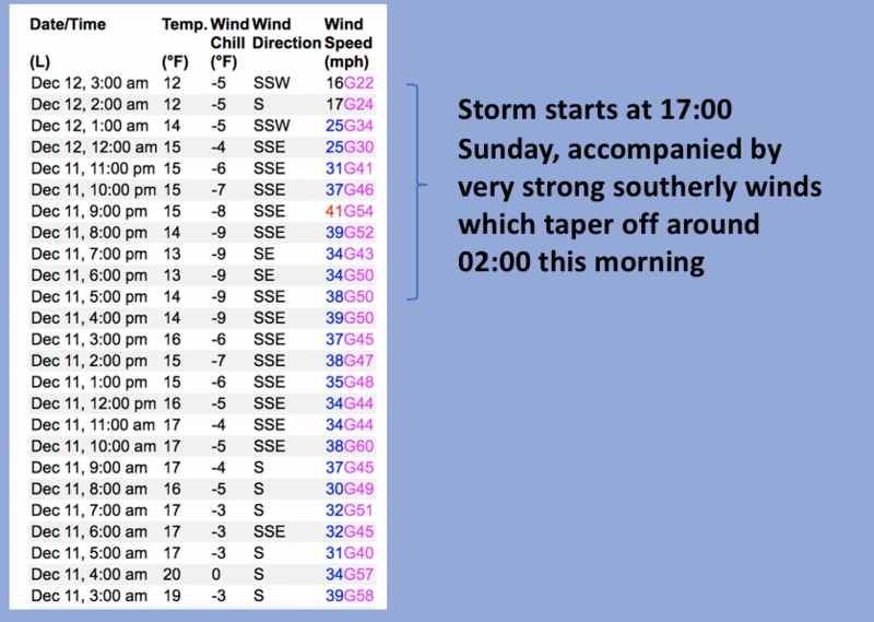
24 hour data dump from Windy Peak (10,661') clearly depicts the recent cow-tipping, snow transporting winds.
Sunday's wind drifts were shallow, predictable, and straight-forward. But, with some overnight snow to work, today's fresh drifts are gonna be more widespread and more sensitive to our additional weight. And once initiated, this big brother version carries the possibility of snow breaking deeper and wider than we might expect. Found mostly on the leeward side of upper elevation ridges, I'd also be on the look out for drifting around terrain features like chutes and gullies. In either case, you'll wanna look for and avoid any fat looking rounded pillow of snow, especially if it sounds hollow like a drum.
Easily managed and avoided with terrain choices... lose the wind, you lose the problem and score great riding conditions to boot.
Additional Information
Last nights forecaster discussion ruminating over the currant snowpack setup
And... we were super busy this summer upgrading the western Uinta weather station network and this real-time winter info is found HERE (click weather stations, and then on the Western Uinta tab)
Your observations are important, so please let me know what you're seeing... click HERE and contribute to this amazing community-based program
General Announcements
Issued at 03:47 on Monday December 12th, this forecast expires 24 hours after the date and time posted, but will be updated by 07:00 Tuesday December 13th.
Before it gets too crazy, now is the time to book an avalanche awareness presentation for your group, club, or posse. You can reach Craig directly at 801-231-2170 or [email protected].
This forecast is from the U.S.D.A. Forest Service, which is solely responsible for its content. This forecast describes general avalanche conditions and local variations always occur.