

Forecast for the Uintas Area Mountains

Issued by Craig Gordon for
Thursday, December 16, 2021
Thursday, December 16, 2021
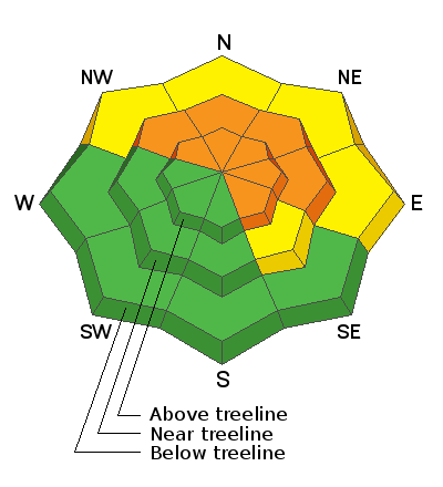
A CONSIDERABLE avalanche danger exits on steep, mid and upper elevation terrain facing the north half of the compass and HUMAN TRIGGERED AVALANCHES ARE LIKELY. Avoid being on, under, or adjacent to steep wind drifted slopes, particularly those that harbor old October snow. And remember... any avalanche that fails on older snow will result in a dangerous slide breaking 2'-4' deep and a couple hundred feet wide, instantly ruining your day. In addition, recent strong winds formed fresh drifts in lower elevation terrain where you'll find MODERATE avalanche danger. Human triggered avalanches are POSSIBLE on steep, wind drifted slopes facing the north half of the compass.
But here's the good news- simply switch aspect or lose elevation and set your sights on terrain that was bare prior to our recent round of storms. You'll find generally LOW avalanche danger on slopes with these characteristics.
Low
Moderate
Considerable
High
Extreme
Learn how to read the forecast here
 Weather and Snow
NOWCAST-
Thickening clouds filtered into the region overnight and southwest winds clocked in for the swing shift around 5:00, blowing through the night in the 30's and 40's along the high ridges. Temperatures crawl out of the deep freeze and currently register in the single digits and low teens. The midweek storm delivered over a foot of evenly distributed snow. And though it's still a bit lean for mid December with total settled snow depths hovering right around 30", the riding and turning conditions have vastly improved in the past few days.
FORECAST-
A weak storm slides into the area as the day progresses, but compared to our last storm, accumulations look a bit underwhelming, with just 4"-8" expected. Southwest winds are gonna be a nuisance with hourly averages in the 30's and gusts near 50 mph along the high peaks. High temperatures climb into the low to mid 20's.
FUTURECAST-
Snow showers taper off by early Friday as high pressure builds. It should be a beautiful end to the work week with clearing skies and cold temperatures through the weekend. Another storm is slated the arrive late Tuesday.
Looking for real-time temps, snow, or wind?
Click HERE and then on the "western Uinta" tab for western Uinta specific, weather station network.
 Recent Avalanches

Yesterday, ace observer Michael Janulaitis stomped along a ridgeline in Weber Canyon and released a piece of cornice which then broke out a small section of slope below. MJ said this about our current setup... "The slab collapsed a length of 400ft but only two sections of it were overloaded enough to pull out and run. The evidence showed a well-connected cohesive slab that formed from persistent south winds." His most excellent observation, along with current snowpack assessment is found HERE
In addition, near-by terrain along the Park City and Millcreek ridgeline with similar snow structure is producing large avalanches breaking to weak, October snow.
Observations, trip reports, and avalanches found here.
Your input is vital and we're interested in what you're seeing. Please contribute to this great community resource and go here to fill out an observation.

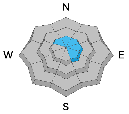
Avalanche Problem #1
Persistent Weak Layer
Type
Location
Likelihood
Size
Description
The snowpack is settling and gaining strength and that's good news! Fact is, travel is becoming easier and the snow will feel strong and solid under our skis, board, or sled. But, therein lays the problem, because this strong cohesive slab rests on fragile, old October snow... or what we call a persistent weak layer (PWL). So we've got a deceptively tricky snowpack setup right now and we've gotta think not only about the snow we're riding in, but also the snow we're riding on. Yep... this is the classic "strong snow on weak snow" setup and that's always a dangerous combination in our mountains. This combo makes us feel safe and often allows us to get well out onto the slope before the weak layer fails (often around a bush or rock we can't see under the snow), the avalanche breaks above us, and now the entire seasons snowpack crashes down on top of us.
Now here's where it gets tricky... there's a fresh blanket of snow coating our mountains and everything's gonna look white. In fact, it'll be more difficult to determine what slopes held early season snow. But remember... terrain that faces the south half of the compass and lower elevation slopes were bare prior to last weeks big storm. And while there's plenty of gear wrecking rocks and stumps to slam into, there's no old snow and avalanche issues are more predictable and straight-forward.
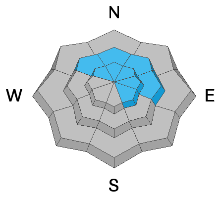
Avalanche Problem #2
Wind Drifted Snow
Type
Location
Likelihood
Size
Description
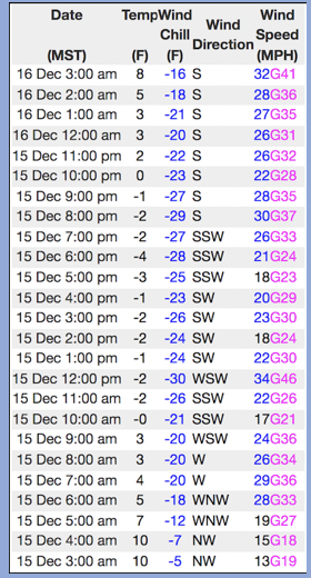
Above is a 24 hour data dump from Windy Peak (10,662') showing a brief respite, but then another round of ridgetop winds developing overnight.
Winds ramped up overnight and whipped up yet another round of fresh wind drifts and those now cover over all the drifts created early in the week... yes, it's getting complicated! So, a good rule of thumb when the avalanche equation gets tricky is to simply keep things simple... observer of the obvious, right? Yeah, simply avoid any steep slope facing the north half of the compass, especially if it appears fat and rounded or sounds hollow like a drum. And remember- any avalanche that initiates in the new snow may break deeper and wider as it crashes down on the slope below, creating a larger slide than you might expect.
Additional Information
Your observations are important, so please let me know what you're seeing... click HERE and contribute to this amazing community based program
General Announcements
The information in this forecast expires 24 hours after the day and time posted, but will be updated by 07:00 Friday December 17th.
Before it gets too crazy, now is the time to book an avalanche awareness presentation for your group, club, or posse. You can reach me directly at 801-231-2170 or [email protected]
This forecast is from the U.S.D.A. Forest Service, which is solely responsible for its content. This forecast describes general avalanche conditions and local variations always occur.