

Forecast for the Uintas Area Mountains

Issued by Craig Gordon on
Friday morning, December 16, 2022
Friday morning, December 16, 2022
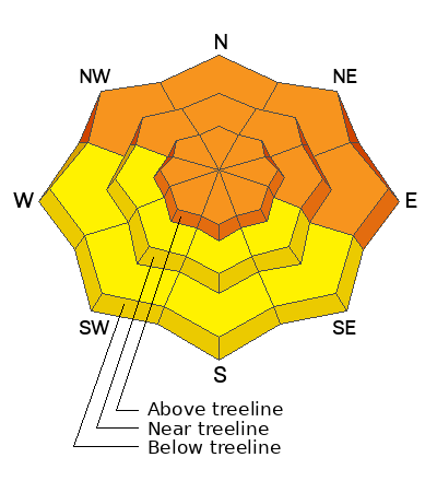
It's light, it's fluffy, it's epically deep, but new snow isn't affecting the avalanche danger. Underneath the blower pow, strong snow rests on weak snow... creating deceptively DANGEROUS AVALANCHE CONDITIONS. Today, you'll find CONSIDERABLE avalanche danger on all steep, shady slopes. The danger is most pronounced in terrain facing the north half of the compass in the wind zone at and above treeline. Human triggered avalanches breaking to weak, sugary, midpack snow are LIKELY. Lower elevation slopes on the south half of the compass with similar layering offer MODERATE avalanche danger and human triggered avalanches are POSSIBLE.
Wind sheltered terrain with no overhead hazard (meaning, no steep slopes above or adjacent to where I'm traveling) is the hot ticket. I've been finding excellent riding conditions and fun meadow skipping on mellow, wind sheltered slopes with no overhead hazard.
Low
Moderate
Considerable
High
Extreme
Learn how to read the forecast here
Special Avalanche Bulletin
Dangerous and unusual avalanche conditions will last through the weekend. Heavy snowfall this past week created dangerous avalanche conditions at all elevations. Don’t be lured by the beautiful sunny skies and fresh powder into thinking avalanche conditions are safe... they are not!
Do not travel on, underneath, or adjacent to slopes 30 degrees or steeper on slopes facing northwest, north, northeast, and east where triggering large and dangerous avalanches is likely. This includes low-elevation foothills where avalanches can occur not far from parking areas and trailheads.
 Special Announcements
Huge thanks all our local heroes, the hard working gals and guys who have given so much of themselves the past few days and nights to save the lives of two very lucky backcountry riders. I am honored to know you and we are all grateful for your dedication and service!
We have dodged a few bullets with two close calls in the backcountry Tuesday and Wednesday. One in Pink Pine the other in Neff's Canyon.
Both Mirror Lake Highway and Wolf Creek Pass are closed for the season
 Weather and Snow
Nowcast- Skies slowly clear in the wake of this weeks big storm which stacked up 24" of snow with just barely 1.5" of H2O. About half that amount piled up on the south half of the range. In either case, it's epically deep and remarkably light. This morning, temperatures hover in the single digits near the trailheads and negative territory along the ridges. In the past 24 hours, northerly winds bumped into the 20's and 30's near the high peaks and that equates to a finger numbing, diesel gelling, wind chill registering to -25 degrees... ouch.
Forecast- Look for mostly sunny skies and very crisp temperatures which barely climb into teens. Northerly winds blow 20 to 30 mph along the high ridges. With clear skies on tap, overnight lows free fall into negative territory.
Futurecast- Mostly sunny skies, northerly winds, and cold temperatures are on tap for the weekend.
KA-POW!
This weeks storm totals register close to 24" of snow with just about 1.5" of H2O. In other words... over-the-hood and over-the head!
Lots of excellent trip reports and recent obs are found HERE.
 Recent Avalanches
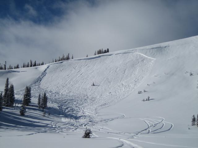
Ted got some eyes on Tuesday's Double Hill slide that was remotely triggered by a crew of riders low on the slope. Ted is one avy-savvy cat and forecaster extraordinaire, who knows the Uinta's like no one else. His very informative writeup and keen snow sense is found HERE.
Recent avy activity and a slew of Uinta obs are HERE.

Avalanche Problem #1
Persistent Weak Layer
Type
Location
Likelihood
Size
Description
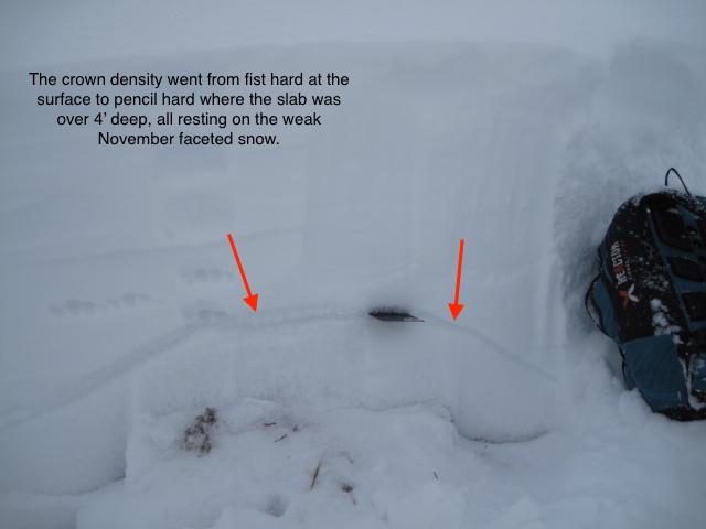
Strong snow on weaker snow, this is what the structure looks like at the crown of the sled triggered Double Hill avalanche from earlier this week.
And this is what it looks like in a snowpit. Mark and Micheal J stomped around the Hoyt Peak environs Wednesday confirming all our snowpack suspicions... the weak, sugary, and persistent weak layer (PWL) in the mid portion of our snowpack is still quite reactive.
The good, the bad, and the potentially ugly-
Our recent round of ultra-blower pow isn't going to wake up the avalanche dragon, but pull back the curtain and a more nefarious setup is revealed... and here's what's going on. Last weekends wind formed a dense, strong slab, but that solid layer rests on weaker snow (Persistent Weak Layer or PWL) formed during the mid November dry-spell. Now here's where it gets tricky, this setup gives us a false sense of snow stability, because it feels bomber and good to go underneath our skis, board, or sled. In fact, this combo often lures us well out onto steep slopes before weak layers fail, allowing avalanches to break well above us and the whole roof crashes down. So yes, I'm thinking not only about the snow I'm riding in, but also the snow I'm riding on. Here's where the rubber hits the road and what makes things tricky right now... any avalanche that fails near the midpack weakness (PWL), is gonna break deep and wide and it's gonna be dangerous.
Unless you take your shovel out, dig down and investigate a bit, you can easily get lulled into a false sense of snow stability because the snowpack has gained a substantial amount of buoyancy. Yep, that pack's got a whole lotta body... baby :)
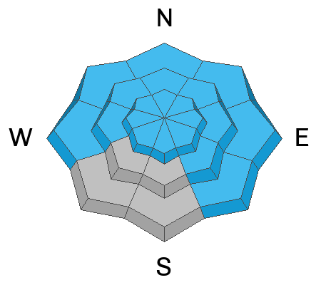
Avalanche Problem #2
Wind Drifted Snow
Type
Location
Likelihood
Size
Description
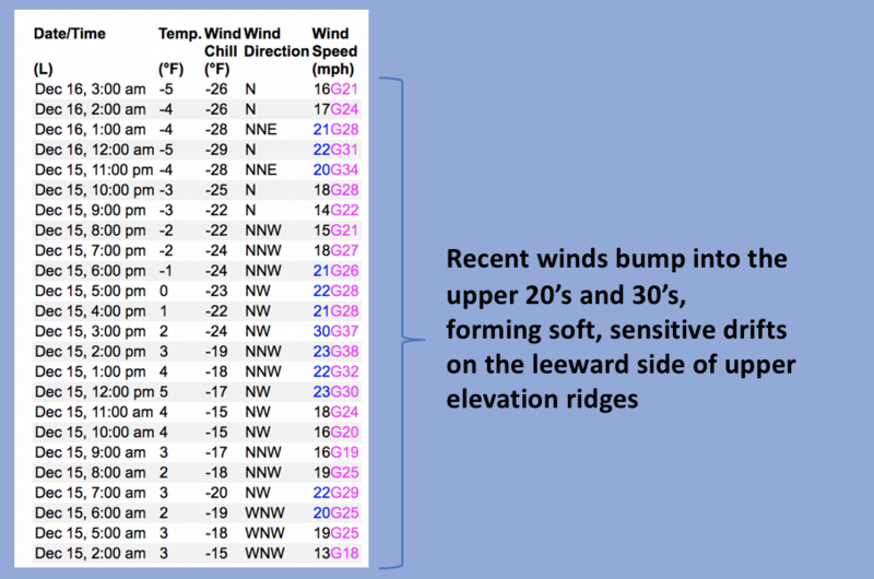
24 hour data dump from Windy Ridge (10,662') depicts an uptick in wind along the high peaks.
Low density snow is no match for the bump in recent winds, easily whipping up a fresh batch of shallow, yet sensitive drifts along the leeward side of ridges and around terrain features like chutes and gullies.
Here's where it gets tricky... once initiated, a seemingly harmless shallow drift can get quickly out of hand if it breaks to older, weaker, midpack snow. Found mostly on the leeward side of upper elevation ridges, I'd also be on the look out for drifting around terrain features like chutes and gullies. In either case, you'll wanna look for and avoid any fat looking rounded pillow of snow, especially if it sounds hollow like a drum.
Hot ticket and where to ride-
Easily managed and avoided with terrain choices... lose the wind, you lose the problem, and score great riding conditions to boot. Done, done, and done :)
Additional Information
And... we were super busy this summer upgrading the western Uinta weather station network and this real-time winter info is found HERE (click weather stations, and then on the Western Uinta tab)
Your observations are important, so please let me know what you're seeing... click HERE and contribute to this amazing community-based program
General Announcements
Issued at 03:58 on Friday December 16h, this forecast expires 24 hours after the date and time posted, but will be updated by 07:00 Saturday December 17th.
Before it gets too crazy, now is the time to book an avalanche awareness presentation for your group, club, or posse. You can reach Craig directly at 801-231-2170 or [email protected].
This forecast is from the U.S.D.A. Forest Service, which is solely responsible for its content. This forecast describes general avalanche conditions and local variations always occur.