Forecast for the Uintas Area Mountains

Mark Staples
Issued by Mark Staples for
Friday, December 17, 2021
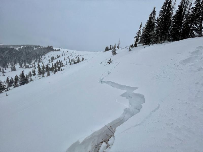
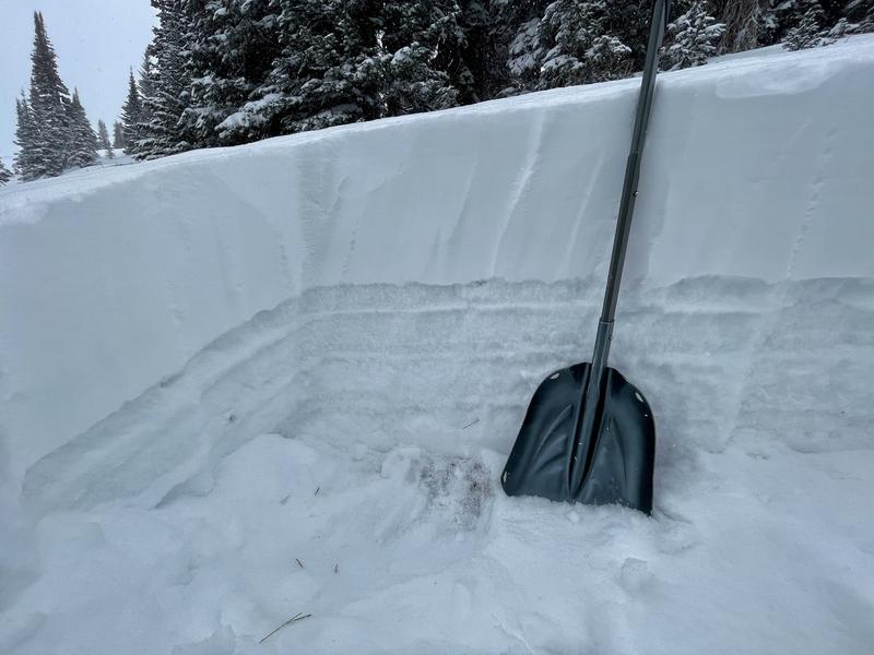
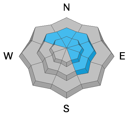
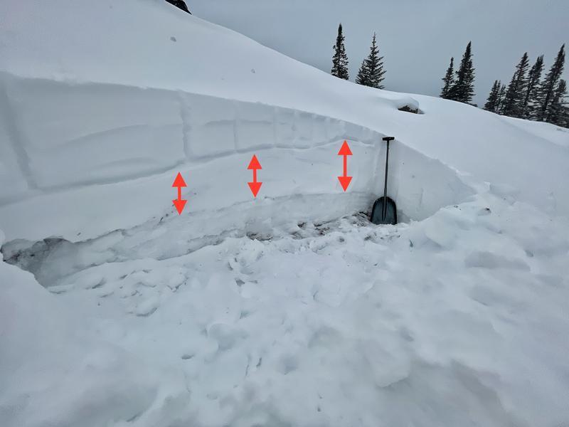
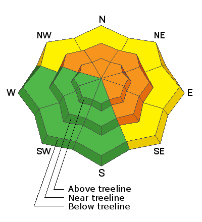
Triggering an avalanche today is likely on slopes facing north, east, and even southeast near and above treeline where the avalanche danger is CONSIDERABLE. The combination of a persistent weak layer of old October snow with a slab of new snow and wind drifted snow on top of it will produce avalanches. Lower elevations on these aspects below treeline have a MODERATE danger.
A LOW danger exists on slopes facing west and south where winds have stripped away snow and where old, weak, October snow doesn't exist. The problem is that there is minimal snow in these places and there is deeper snow where the avalanche danger is higher, so the answer is to simply ride low-angle slopes.
Low
Moderate
Considerable
High
Extreme
Learn how to read the forecast here
Weather and Snow
NOWCAST-
2-5 inches of snow fell yesterday. This morning, temperatures are in the single digits F at upper elevations, and in the mid-teens F at lower elevations. Winds eased some yesterday but picked up again this morning blowing from the west-southwest 30 mph gusting to 45 mph on the high peaks. At lower elevations, winds are averaging 5-10 mph gusting to 20 mph. With such cold temps, any wind will feel like a lot and will push wind chills well below zero.
FORECAST-
Some snow should fall today under mostly cloudy skies with only an inch or so accumulating. Winds will ease and shift, blowing from the northwest at 15-20 mph. They will also bring more cold air and keep temperatures from warming any today.
FUTURECAST-
Skies will begin clearing either this afternoon or this evening making way for sunshine this weekend. Tonight's low temperatures will drop to zero degrees F and then warm into the 20s F for Saturday and possibly reaching the low 30s F by Sunday. Clouds return Tuesday and some snow should fall Wednesday and Thursday.
Looking for real-time temps, snow, or wind?
Click HERE and then on the "western Uinta" tab for western Uinta specific, weather station network.
Recent Avalanches
Yesterday near Wolf Creek Pass, I triggered large collapses with huge shooting cracks on two wind-loaded, north-facing slopes. If they had been any steeper they would have produced avalanches. These shooting cracks and collapses are a huge red flag from the snowpack.
On Wednesday, ace observer Michael Janulaitis triggered a small, wind-loaded slope above Weber Canyon.
A little to the west, along the Park City and Millcreek ridgeline, similar snow layering exists and large avalanches are breaking in the old, weak, October snow.

Observations, trip reports, and avalanches found here.
Your input is vital and we're interested in what you're seeing. Please contribute to this great community resource and go here to fill out an observation.
Ad
Avalanche Problem #1
Persistent Weak Layer
Type
Location
Likelihood
Size
Description
There are two overlapping avalanche problems. (1) Old October snow became weak and faceted during dry weather in November and is now a persistent weak layer with a soft slab of December snow on top of it. See the obvious layers of faceted snow (bottom) and new snow (top) in the photo below. (2) Winds blowing from the south and southwest during the last week have loaded and put a hard slab on top of many slopes harboring the old, weak, faceted October snow.
The most likely place to get a slab avalanche are slopes that have both old October snow and wind drifted snow. Since winds have been mostly blowing from the south, I'd assume that any northerly facing slope near or above treeline has both these ingredients.
The dilemma is that terrain with the deepest snow is generally where this avalanche problem exists, so the main way to avoid avalanches is to ride low angle slope which are ones less than 30 degrees in steepness.
Avalanche Problem #2
Wind Drifted Snow
Type
Location
Likelihood
Size
Description
Winds from the south and southwest have stripped many slopes and loaded many others with hard slabs of wind drifted snow. The effects of strong winds last weekend and early this week are now camouflaged by snow that has fallen this week. Winds continue to drift newly fallen snow. The issue with this avalanche problem is that where the winds are depositing snow is on many slopes that harbor a persistent weak layer of old October snow.
The photo below from Wolf Creek Pass shows a very hard (pencil hardness) layer of wind drifted snow from early this week denoted by the red arrows. The new snow on top hides this very hard layer, but under all of it is weak faceted snow that can fracture and produce an avalanche.
Additional Information
Your observations are important, so please let me know what you're seeing... click HERE and contribute to this amazing community based program
General Announcements
The information in this forecast expires 24 hours after the day and time posted, but will be updated by 07:00 Friday December 17th.
Before it gets too crazy, now is the time to book an avalanche awareness presentation for your group, club, or posse. You can reach me directly at 801-231-2170 or [email protected]
This forecast is from the U.S.D.A. Forest Service, which is solely responsible for its content. This forecast describes general avalanche conditions and local variations always occur.