Dave Kelly
Forecaster
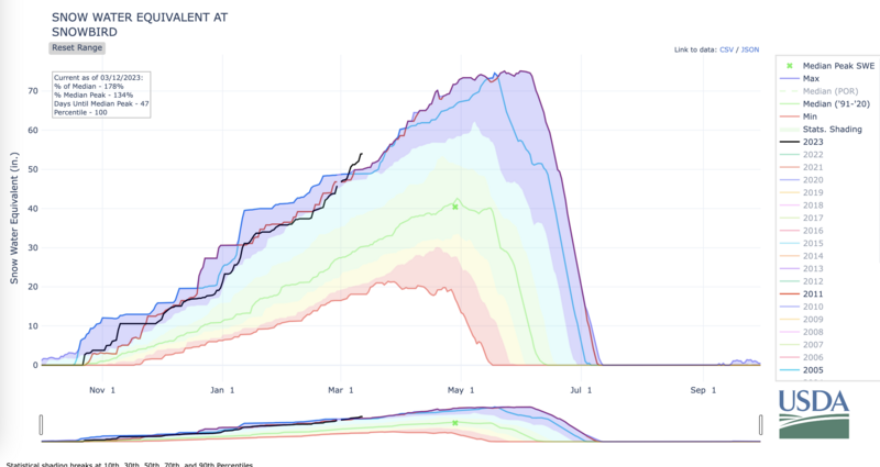
Spring has sprung and we’re just now passing the max SWE (snow water equivalent) for Snowbird (black line) for this time of year. Not that we needed a chart to know that this is the type of season that keeps people in Utah for decades. You can tell by the smiles on riders’ faces, and talking to friends who are too tired to keep skiing, but keep after it because it’s that good. There are decisions being made right now that will change the path of someone’s life long into the future and they involve sliding on snow in the mountains. So simple- yet so rewarding.
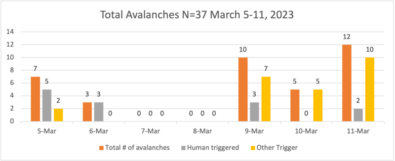
It was difficult the morning of March 12 to come up with a solid avalanche problem for today’s forecast. When it comes to general avalanche conditions something didn’t sit right. There were 17 avalanches reported to the UAC from Friday March 10- Sunday March 12 (heat map below), not including the ones that ski area operations triggered.
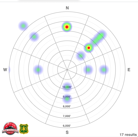
Out of those 17 avalanches, 2 were confirmed as triggered by the party that reported them, one of the reports was from explosive work in Slide Canyon performed by UDOT Provo to keep SR 189 safe. That leaves 14 reported avalanches that had some other trigger. This is where the complications come in because those 14 other avalanches did not have a pattern that was discernable. This in turn made me pause when I thought about where I would travel today or how I would recommend that other people travel when I was writing this morning’s forecast… and not just because it was Daylight Savings Time.
It was hard to find a pattern, there was no single avalanche problem that summed it up. Simple would have been to stick with the fact that natural and human triggered avalanches have occurred and with more snow and wind there is a possibility of continued avalanche activity, oh and it’s March so if the sun comes out…
Normally I would be working into bigger terrain right now. It’s spring! But the open-season mindset doesn’t fit the current scenario. We’ve had so much snow and such little sun that the solar aspects are acting like the polars and the relentless winds keep loading up the leeward aspects and cornices are huge! I am stepping back from what I would be skiing this time of year. Right now, there is a general avalanche danger in the backcountry of Northern Utah that shows me that avalanches are possible and hard to pin down.
What has complicated things is that we have had a lot of snow over the last few weeks and there are areas where we are finding decomposing stellar crystals, buried ice crusts, rime crusts, and isolated areas of faceted snow buried 1-3' below the surface and it's a good reminder that strange weather (like above average snowfall) leads to strange avalanches. The current avalanche problem is tricky. There is no cut and dry answer- the continued snowfall, the widespread avalanche activity, all of these factors lead me to have apprehensions. Until a pattern emerges my solution is to find lower angle terrain and practice good mountain etiquette exposing only one person at a time to a slope.
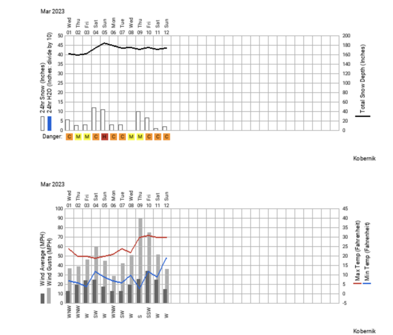
The following graphs are what I looked at to try and find a pattern. What stood out to me besides continued snowfall was the increased wind gusting to 90 MPH from the south on March 9, 2023. The other event that stood out was the number of avalanches reported on March 11 that were not human-triggered. This fact alone made it difficult to drop the danger to less than Considerable in upper elevation terrain on the morning of March 12.
Avalanche heat map from March 5-11, 2023.
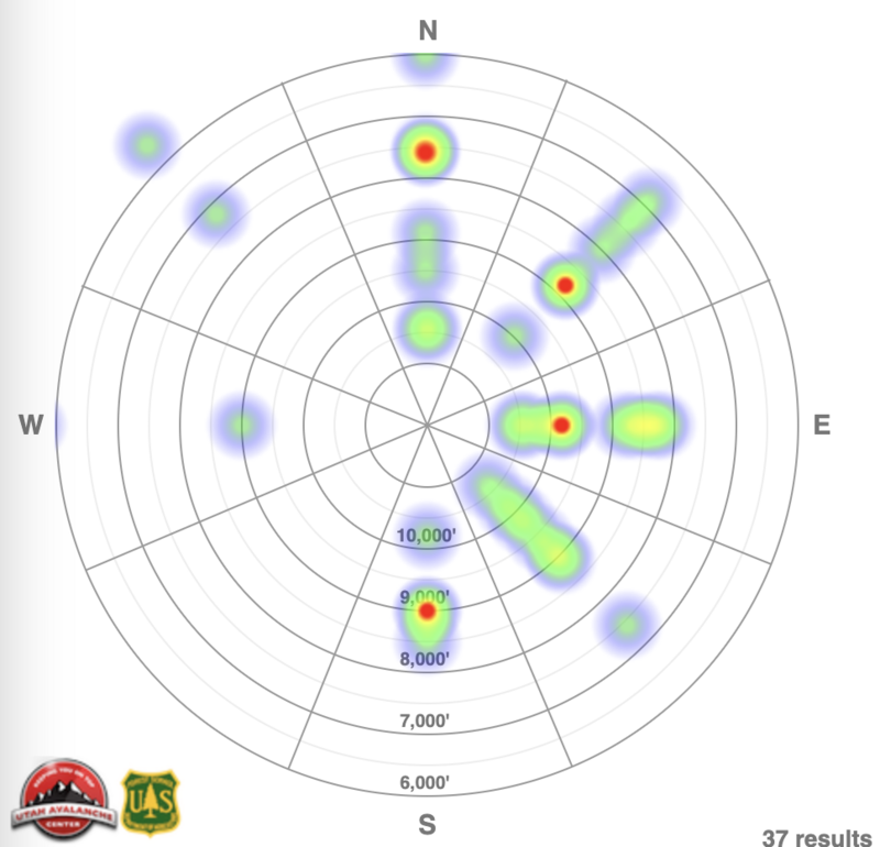
Bar graph of avalanches March 5-11, 2023
Utah Avalanche Center graph showing wind, temperatures, avalanche hazard, total snowfall
Snow Water Equivalent at Snowbird. Accessed March 12, 2023.
Statham, Grant et al (2016). A Conceptual Model of Avalanche Hazard. Nat Hazards DOI 10.1007/s11069-017-3070-5.
Thanks Dave, well put. It's been tricky to relay to my newer patrollers how bizarre and difficult this snowpack is; and now that it's mid march, everything changes so rapidly if the sun says hello. Appreciate the work.
brighton
Tue, 3/14/2023
- reply
Thanks- that tricky communication seems to be running across operations right now. Welcome spring!
Dave
Wed, 3/15/2023
I appreciate this essay. Looking at the snowpack and coming off two years of conservatism, I am eager to go higher and steeper than I have been and develop more nuanced terrain assessment and also to ride bigger terrain. Aside from a window in January, I have been feeling stymied by weather and conditions not feeling 100% despite amazing coverage, the primary PWL healing, and constant fresh snow. It is helpful to have this writing to contextualize this for me and to remind me that I am behaving rationally, not missing out on "my chance" to finally ride the dream terrain I've been mostly staring at the last few years. I hope we get good opportunities to enjoy the full contours of the range this spring.
charles (not verified)
Tue, 3/14/2023


