Forecast for the Salt Lake Area Mountains

Dave Kelly
Issued by Dave Kelly for
Sunday, March 12, 2023
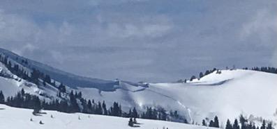
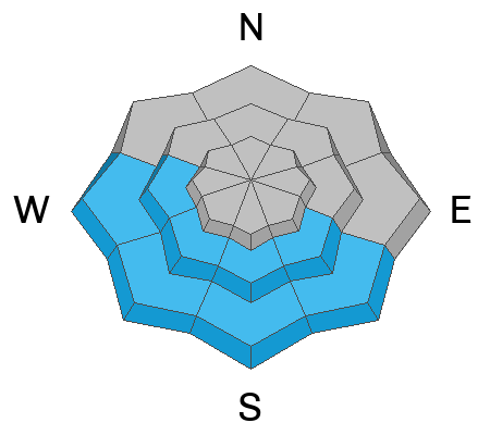
There is a CONSIDERABLE avalanche danger in the upper elevation zone for wind-drifted snow avalanches that may be 1-3' deep and up to 200' wide. There is a MODERATE avalanche hazard in mid and lower elevation terrain.

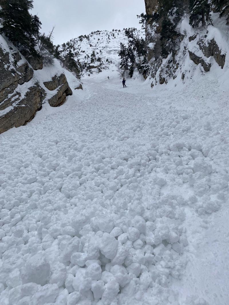
With today's new snow expect to see loose-dry avalanches in steep terrain. There is a possibility that you may find an isolated avalanche breaking on an old/new interface which could be 1-3' deep. Any hint of sun will rapidly warm the new snow and rocky gully features can be dangerous places if you get caught in a slough that pinballs you down the slope.

Only expose one rider to a slope at a time and keep an eye on your partners when traveling in terrain steeper than 30 degrees.
Low
Moderate
Considerable
High
Extreme
Learn how to read the forecast here
Special Announcements
The UAC is currently working with the operation involved in Thursday's fatal avalanche in the Uintas to prepare a report. Please be patient as we sort out the details of this complicated incident. A preliminary report is available HERE.

Please consider donating to the spring campaign to help our team implement innovative tools and better provide you with the information you rely on.
Weather and Snow
Under overcast skies trailhead temperatures are in the mid-20's ˚F while the highest ridgeline temperatures are in the high teens ˚F. Winds have decreased in speed since yesterday and are blowing from the west in the 20's gusting to the 30's at the 11,000' ridgelines and from the southwest in the mid-teens gusting to the 20's MPH at the 9,000' ridgelines. It is snowing lightly at most mountain locations and we are seeing 1-2" of new snow on the ground.

Today, winds will blow from the west-southwest 15 to 25 MPH at the 9,000' ridgelines and 30 gusting to 45 MPH at the 11,000' ridgelines. Temperatures will be 33-36 ˚F. Skies will be overcast this morning with 4-6" of snow forecasted. There may be snowfall rates up to 1" an hour starting at 9AM. The freezing level will hover around 6500' throughout the day.
Recent Avalanches
Yesterday we had reports of avalanches from all aspects and elevations. Get all observations HERE.

Spring time in the mountains means that things can change quickly and there can be an assortment of avalanche problems within an hour or an aspect of one another. It is a good time to year to be willing to adapt and change your plan if the weather or snow conditions change.

There is a good refresher on recognizing RED FLAGS HERE.
Ad
Avalanche Problem #1
Wind Drifted Snow
Type
Location
Likelihood
Size
Description
Yesterday, ski area operations reported wind-drifted snow avalanches reactive to explosives. Sometime early yesterday morning a natural avalanche occurred on Scott's Hill on the Park City Ridgeline. I wouldn't trust a steep wind-loaded slope this soon after a loading event. The issue is that in a lot of places the stiffer wind-drifted snow from Friday's storm may be covered over by new snow. Avoid these steep wind-loaded slopes.
Photo (PC Patrol)

Cornices are currently large and growing. Give cornices, and the edges of cornices a wide berth as they often break farther back than expected. Limit your exposure to slopes below cornices. Cornices are signs that a slope has been wind loaded and a cornice fall could trigger a larger slab of wind-drifted snow below.
Avalanche Problem #2
Wet Snow
Type
Location
Likelihood
Size
Description
Any steep slope or rocky cliff band will shed new snow with the first hint of warm March sun. This is of particular concern to ice-climbers and riders ascending or descending steep gullies. We had reports of a wet avalanche under an ice climb in Willard Canyon from a few days ago, and a close call with an ice climbing group in Santaquin Canyon from yesterday. We also had a report of a loose wet sluff out of Mt Olympus during a period of warming.
Photo (A. Sand)
Avalanche Problem #3
New Snow
Type
Location
Likelihood
Size
Description
Expect to see loose-dry avalanches on steep slopes during periods of higher snowfall rates.

We have had a lot of snow over the last few weeks and there are areas where we are finding decomposing stellar crystals, buried ice crusts, rime crusts, and isolated areas of faceted snow buried 1-3' from the surface and it's a good reminder that strange weather (like above average snowfall) leads to strange avalanches. There is a possibility of triggering an isolated avalanche on a new/old snow interface that is buried 1-3' from the surface. The solar aspects, particularly southeasterly facing slopes are acting more like a northerly aspect.

This avalanche in Big Springs is characteristic of the types of large avalanches you may find in isolated areas.
Additional Information
While not directly avalanche problems, tree wells, "snow immersion suffocation" is a backcountry danger worth noting. Read more HERE.
With so much snow on rooftops in mountain communities, roof avalanches will be a significant hazard as the sun warms roofs in mountain neighborhoods. Children playing and adults shoveling solo are especially vulnerable to this hazard.
General Announcements
This information does not apply to developed ski areas or highways where avalanche control is normally done. This forecast is from the U.S.D.A. Forest Service, which is solely responsible for its content. This forecast describes general avalanche conditions and local variations always occur.