Forecast for the Skyline Area Mountains

Brett Kobernik
Issued by Brett Kobernik for
Saturday, January 21, 2023
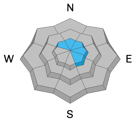
The majority of the terrain on the Skyline has a LOW avalanche danger rating today.
There is a "pockety" MODERATE danger rating in the upper elevation very steep terrain that faces northwest through southeast where the wind has formed recent drifts and slabs of snow.
Human triggered avalanches are unlikely unless you are really pushing into steep, radical upper elevation terrain.
Low
Moderate
Considerable
High
Extreme
Learn how to read the forecast here
Special Announcements
FREE AVALANCHE BEACON TRAINING today, Jan 21 from 9am to 1pm at the north Skyline Drive parking lot at the top of Fairview Canyon. Come by anytime between 9 and 1 and we will spend about a half hour with you teaching you how to properly use your avalanche beacon, shovel and probe.
Weather and Snow
Current Conditions: It looks like the Skyline picked up another 2 to 4 inches of low density snow last night. There was still light snowfall at 7am. This is going to be the icing on the cake to already world class riding conditions. Temperatures were around 20˚F on Friday and dipped into the single digits to low teens overnight. Wind has been mostly light from the west. There's been a slight increase in speed along the highest terrain.
Mountain Weather: Light snowfall will end and clouds should break as the morning progresses. There is enough low level moisture that may produce clouds over the peaks during the day. Temperatures will get into the mid teens to around 20˚F today. Wind will be from the west northwest with light to moderate speeds. It may blow just hard enough to transport and drift snow in the higher terrain. There is another weak storm that will move through on Sunday that might bring a few more inches of snow. It looks like a fairly quiet week of weather ahead with some minor disturbances. The weather models are then suggesting a more active pattern around the beginning of the month.
Ad
Avalanche Problem #1
Normal Caution
Type
Location
Likelihood
Size
Description
Use normal caution today.
  • Watch for any drifting of the new snow along the higher terrain today.
  • Look for fresh drifts and "pillowy" looking formations along the ridges and peaks and avoid them where they may have formed on steep slopes.
  • Watch for cracking around your skis, snowboard, snowshoes or snowmobile which indicates instability.
  • If you choose to get onto steeper terrain, only expose one person at a time.
  • Clear the runout zone at the bottom. In other words, don't regroup right at the bottom of a steep slope.
It is going to be one of the best riding days of the year. If you use a little common sense and don't push it too hard, you'll have an awesome and safe day.
General Announcements
This forecast is from the U.S.D.A. Forest Service, which is solely responsible for its content. This forecast describes general avalanche conditions and local variations always occur.