Forecast for the Skyline Area Mountains

Brett Kobernik
Issued by Brett Kobernik for
Sunday, January 22, 2023
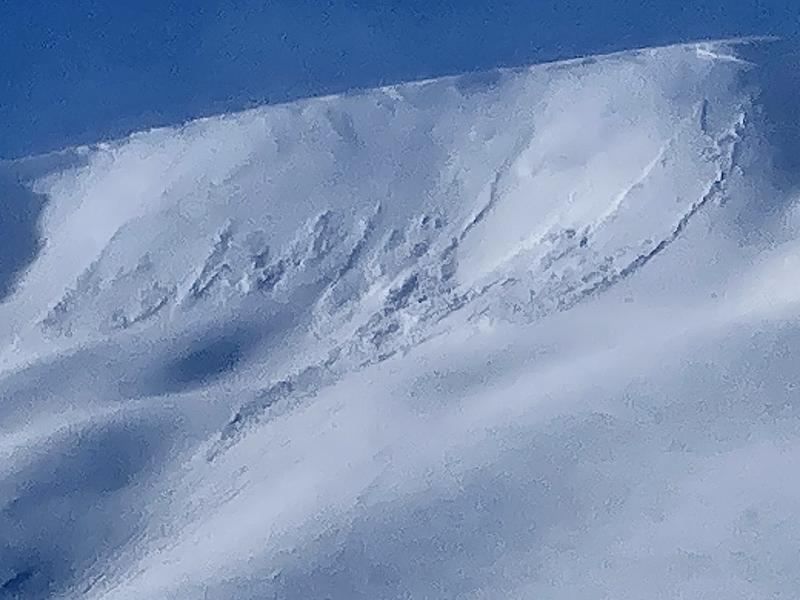
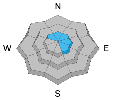
There is a MODERATE avalanche danger rating in the upper elevation steep slopes that face northwest through southeast.
Recent wind has drifted snow and formed sensitive wind slabs especially right along the ridgelines.
Human triggered avalanches are possible where these slabs and drifts have formed.
If you avoid the drifts and slabs, the avalanche danger is LOW.
Low
Moderate
Considerable
High
Extreme
Learn how to read the forecast here
Weather and Snow
Current Conditions: The wind increased more on Saturday than I anticipated. It was definitely moving snow along the higher terrain in many locations across the Skyline. Riding conditions remained excellent out of the wind effected snow. Overnight temperatures were in the teens. I looks like the wind has stayed about the same speed so I'm assuming more drifting occurred overnight. It is a bit more from the southwest this morning.
Mountain Weather: We'll have partly cloudy skies this morning. We might see a bit of the sun if we're lucky. Clouds build in with snow showers likely this afternoon. This small storm will only produce a few inches of snow. Wind will shift and blow from the northwest as the day progresses. Speeds should remain moderate. Temperatures will start heading into the single digits afternoon.
Recent Avalanches
There was some minor natural avalanche activity on Saturday. This was due to the wind drifting the very low density snow. The fresh drifts and slabs were cracking out in a few places right along the ridges. These were not that deep and didn't pose much threat.
Ad
Avalanche Problem #1
Wind Drifted Snow
Type
Location
Likelihood
Size
Description
The wind drifted snow is your main concern today. This is an easily manageable problem by simply avoiding steep slopes where the wind has drifted and deposited snow into slabs. Most likely places to see these slabs are right below ridgelines on northwest through southeast facing steep slopes. These will most likely be less sensitive today compared to yesterday when they were freshly forming. However, they may be a bit deeper now. They don't pose a huge threat unless you start monkeying around with them. Avoidance is key.
General Announcements
This forecast is from the U.S.D.A. Forest Service, which is solely responsible for its content. This forecast describes general avalanche conditions and local variations always occur.