Join us for the 17th Annual Professional Snow and Avalanche Workshop (PROSAW) on November 4 - Purchase tickets here!

Forecast for the Provo Area Mountains

Trent Meisenheimer
Issued by Trent Meisenheimer on
Sunday morning, April 10, 2022
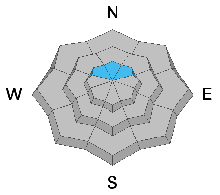
Today we have a MODERATE avalanche danger on slopes facing northwest, north, and northeast at the upper elevations for hard and soft drifts of wind-blown snow. Human triggered avalanches are possible.
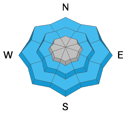
There is also a MODERATE avalanche danger on steep slopes that face northwest, north, and northeast for the possibility of triggering a much larger and more dangerous avalanche that fails 1-2' deep on a buried persistent weak layer.
Risk is inherent in mountain travel, and even a small avalanche can lead to a bad outcome in radical terrain.
Low
Moderate
Considerable
High
Extreme
Learn how to read the forecast here
Weather and Snow
Under partly cloudy skies, the mountain temperatures are frigid compared to the past couple of days. Current temperatures are in the single digits to low teens °F, and wind chills range from -4 to -19 °F. Winds are cranking from the northwest, and upper elevation anemometers are spinning 10-20 mph, gusting into the 30's across many upper elevations. Above 10,500, the northwest wind is blowing 40-50 mph, gusting into the 60's.
Today, we can expect the clouds and sun to play cat and mouse for the day. Temperatures will climb into the mid to upper 20's °F. Winds are forecasted to back to the southwest and decrease in speeds later today. After sundown, southwest winds will pick up once again ahead of a potent storm off the Oregon coast.
The National Weather Service has issued a Winter Storm Watch that's in effect from now until Monday. Hopefully, it will transfer into a Winter Storm Warning as the storm approaches. The storm lands in Utah Monday afternoon with a frontal passage sometime late in the day. Snowfall will start late on Monday, and the heaviest precipitation will be associated with the frontal passage. As the front moves overhead, we will set up a northwest flow for Tuesday into Wednesday with unstable orographic enhancement, and areas favored by a northwest flow could do very well from this storm.
Below is a loop of the GFS 500 millibar height and vorticity and a total precipitation loop showing the storm moving into northern Utah Monday afternoon and the total water we can expect from the storm. Can you tell I am excited?
Recent Avalanches
No new avalanches were reported yesterday.
Ad
Avalanche Problem #1
Wind Drifted Snow
Type
Location
Likelihood
Size
Description
Many surfaces won't have any snow to blow around and drift because they are frozen this morning and there is no snow available for transport. However, dry, cold powder remains on northerly facing slopes above about 9,000' in elevation, and these would be the slopes I would suspect to find some wind drifted snow on.
It's amazing what the wind can do and where it can find snow to drift. Be on the lookout for snow that is actively being drifted by the wind and avoid areas that look pillowy and rounded. Wind drifted snow can also feel stiff/hard and hollow like a drum.
Avalanche Problem #2
Persistent Weak Layer
Type
Location
Likelihood
Size
Description
On upper elevation northerly slopes, any avalanche may step down to a weak layer of facets (persistent weak layer) 1-2' deep, particularly in the southern part of the Provo mountains. These facets are remnant from the dry spell in January and February and are slowly stabilizing.
We have minimal data on this problem, and if you're traveling in the Provo mountains on northerly-facing slopes, I would approach these slopes cautiously. It is worth pulling your shovel out and looking at the snow structure yourself. More info can be found HERE.
Avalanche Problem #3
Normal Caution
Type
Location
Likelihood
Size
Description
Use Normal Caution: Any avalanche type is possible, but the most common would be windslab, loose wet, and loose dry avalanches, and they would be expected to be small. Do not approach a Normal Caution avalanche problem as an “anything goes” situation. Continue to keep your guard up and look for any signs of snow instability. Evaluate snow and weather conditions as you travel.
General Announcements
Who's up for some free avalanche training? Get a refresher, become better prepared for an upcoming avalanche class, or just boost your skills. Go to https://learn.kbyg.org/ and scroll down to Step 2 for a series of interactive online avalanche courses produced by the UAC.
This information does not apply to developed ski areas or highways where avalanche control is normally done. This forecast is from the U.S.D.A. Forest Service, which is solely responsible for its content. This forecast describes general avalanche conditions and local variations always occur.