UDOT PLANNED AVALANCHE CLOSURES!!

Forecast for the Salt Lake Area Mountains

Greg Gagne
Issued by Greg Gagne on
Monday morning, February 21, 2022
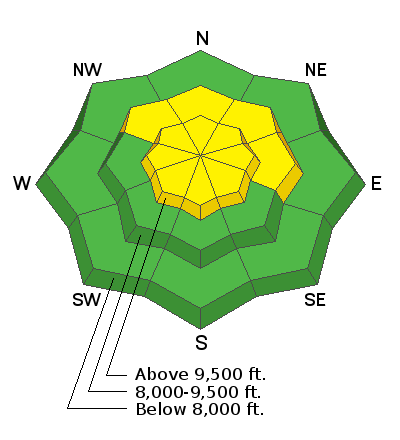
The avalanche danger will rise to Moderate with avalanches possible as snowfall accumulates. Avalanches may involve long-running sluffs and shallow, sensitive soft slabs of new snow at the mid and upper elevations, especially slopes facing northwest through east. Fresh pockets of wind drifted snow may also be found on all upper elevations aspects.

You will need to continually assess the snowpack structure on each slope as new snow and fresh wind drifts will be falling on an existing snow surface that is widely-variable.

We have been able to travel in avalanche terrain with relative impunity over the past 7 weeks but now the avalanche danger is on the rise. Be aware of changing conditions as the day progresses.
Low
Moderate
Considerable
High
Extreme
Learn how to read the forecast here
Weather and Snow
Currently: Temperatures are in the upper teens and winds are from the west/southwest and have decreased after peaking around midnight. At mid-elevations, winds are in the teens with gusts in the 20's mph. Add 10 mph at the upper elevations. Light snowfall began around 6 am.
Today: A cold front will sag through the region today with temperatures in the teens. Winds will be from the west/northwest and moderate, averaging in the low teens with gusts in the low 20's at mid-elevations and slightly higher along exposed upper-elevation ridgelines. Snow totals will depend upon the position of the cold front: the Cottonwoods could see anywhere from 4-10" of new snow throughout the day, with periods of high precipitation possible, especially this morning.
Extended: Unsettled weather with periods of snow expected through Wednesday.
Recent Avalanches
No avalanches reported from Sunday.
Ad
Avalanche Problem #1
New Snow
Type
Location
Likelihood
Size
Description
As snowfall accumulates, avalanches may involve fast and long-running sluffs and shallow senstive soft slabs of new snow. On mid and upper slopes facing northwest through north and east, the top 2-12" of the existing snow surface is weak and faceted and this terrain will be the most suspect. Although I am not expecting any natural avalanches, during any period of higher precipitation intensity or if snowfall comes in higher than forecasted, natural, long-running sluffs could occur on shady slopes with weak faceted snow.
Avalanche Problem #2
Wind Drifted Snow
Type
Location
Likelihood
Size
Description
Although moderate and decreasing winds are forecast, shallow pockets of fresh wind drifts are possible on all upper elevation aspects. Any recent or fresh wind drifts will be sensitive if they have formed on top of weaker snow underneath.

The existing snow surface is widely-variable and this will require assessing the snowpack structure on each slope looking for weaker snow underneath any new storm or wind-blown snow.
Additional Information
On Wednesday, February 16th: Trent Meisenheimer (SLC), Brett Kobernik (Skyline), Drew Hardesty (SLC), and Toby Weed (Logan) discuss the current dry weather and try to reminisce on history in 2007 when a similar dry period happened.
General Announcements
Who's up for some free avalanche training? Get a refresher, become better prepared for an upcoming avalanche class, or just boost your skills. Go to https://learn.kbyg.org/ and scroll down to Step 2 for a series of interactive online avalanche courses produced by the UAC.
This information does not apply to developed ski areas or highways where avalanche control is normally done. This forecast is from the U.S.D.A. Forest Service, which is solely responsible for its content. This forecast describes general avalanche conditions and local variations always occur.