Join us at our 2nd Annual Blizzard Ball

Forecast for the Salt Lake Area Mountains

Trent Meisenheimer
Issued by Trent Meisenheimer on
Sunday morning, February 20, 2022
Today, the avalanche danger is MODERATE across the upper elevations due to increased southerly winds. Small, soft, or hard drifts of wind-blown snow avalanches are possible today. Evaluate snow and terrain carefully; identify features of concern. Out of the wind and lower in elevation, the avalanche danger is LOW.
HEADS UP! with an incoming storm, the avalanche conditions could change drastically within 24 to 48 hrs.
Low
Moderate
Considerable
High
Extreme
Learn how to read the forecast here
Weather and Snow
Southwest flow will increase today ahead of an approaching cold front (storm) that will come through the northern mountains around midnight tonight. Snow should begin to fill in tonight and last into Monday with the hopes of getting 5 to 12 inches of new snow by Tuesday. The good news is it stays relatively active through the week with periods of light snowfall and colder temperatures. The bad news is that this storm doesn't seem to have a lot of moisture. But, as my friend and meteorologist, Larry Dunn likes to say, " if you have enough dynamics, you don't need moisture."
Under clear skies this morning, the mountain temperatures range from 18 to 26 °F. Clear skies will eventually give way to increasing wind and clouds. The winds have backed (turned counterclockwise with height) and are now blowing from the southwest at speeds of 10-20 mph, gusting into the 20's & 30's across the upper elevations. Mountain temperatures will climb into the upper 30's and low 40's °F later this afternoon.
Recent Avalanches
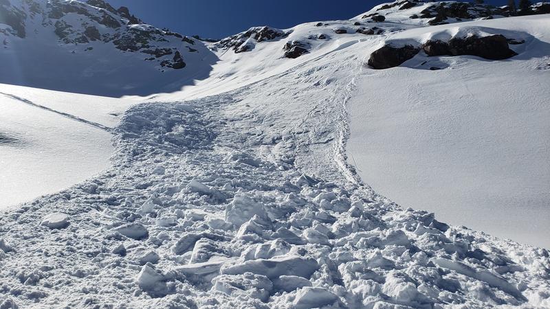
Two small wind slab avalanches were reported yesterday. The first was on Red Baldy and was roughly 12 inches deep 30 feet wide and was likely triggered while climbing uphill, nobody caught. The other wind slab was in Mill B South, and the rider was caught and carried a short distance (uninjured). This second avalanche was also roughly 12 inches deep, 30 feet wide, and ran about 100 vertical feet. Luckily the terrain they were in quickly flattened out without any consequence.
Yesterday in Cooke City, Montana, a snowbiker triggered an avalanche and was caught, strained through some cliffs, and was partially buried with their hand and airbag visible. The rider did not survive. Forecasters from the Gallatin Avalanche Center will visit the site today.

Greg Gagne's Week in Review is published and can be found HERE.
Ad
Avalanche Problem #1
Wind Drifted Snow
Type
Location
Likelihood
Size
Description
With an increase in southwest winds overnight and throughout the day today, our attention should turn to wind drifted snow. Additionally, we have 4 to 8 inches of low-density snow to blow around; I am sure some new drifts will form. These hard or soft drifts of wind-blown snow could be up to a foot deep and could be surprisingly reactive if they form on top of our weak and faceted snow.
Wind-drifted snow often looks wavy, rounded, pillowy, and can sound hollow like a drum when walking or riding on it. As always, it's best to look for and avoid wind-loaded slopes.
Photo: Kyle T. Wind slab avalanche in Upper Mill B South yesterday.
Additional Information
On Wednesday, February 16th: Trent Meisenheimer (SLC), Brett Kobernik (Skyline), Drew Hardesty (SLC), and Toby Weed (Logan) discuss the current dry weather and try to reminisce on history in 2007 when a similar dry period happened.
General Announcements
Who's up for some free avalanche training? Get a refresher, become better prepared for an upcoming avalanche class, or just boost your skills. Go to https://learn.kbyg.org/ and scroll down to Step 2 for a series of interactive online avalanche courses produced by the UAC.
This information does not apply to developed ski areas or highways where avalanche control is normally done. This forecast is from the U.S.D.A. Forest Service, which is solely responsible for its content. This forecast describes general avalanche conditions and local variations always occur.