Forecast for the Salt Lake Area Mountains

Trent Meisenheimer
Issued by Trent Meisenheimer on
Saturday morning, February 19, 2022
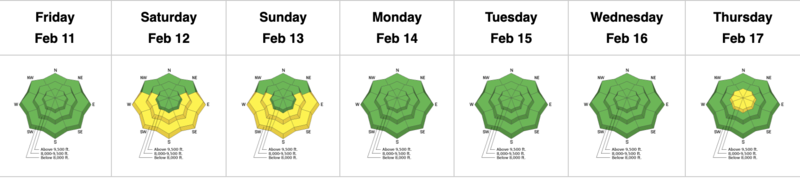
Today, the avalanche danger is LOW in the backcountry. Avalanches are unlikely, and the snow is stable on most slopes with only a few exceptions.
Use normal caution. Watch for and avoid (1) fresh drifts of wind-blown snow on steep upper elevation slopes and (2) new snow or loose recrystallized snow sluffing in very steep terrain.
Low
Moderate
Considerable
High
Extreme
Learn how to read the forecast here
Weather and Snow
Under clear skies, the mountain temperature ranges from 18 to 23 °F across the board. Winds are blowing from the northwest at speeds of 5-10 mph, with the occasional gust into the 20's across the upper elevation ridgelines. At 11,000', the northwest winds are slightly stronger and are blowing 20-25 mph.
For today we can expect clear skies and plenty of sunshine. Mountain temperatures will warm into the upper 20's and low 30's °F this afternoon. Winds will remain from the northwest and blow at speeds of 5-10 mph across the upper elevations.
We have another storm slated for Sunday evening into Monday and another Tuesday into Wednesday. Details are coming soon, but we can expect hopefully 5-10 inches of new snow.
Mark and I went into White Pine on Thursday and found six to eight inches of new snow sitting on various old snow surfaces.
Recent Avalanches
No new avalanches or observations from Friday.

Greg Gagne's Week in Review is published and can be found HERE.
Ad
Avalanche Problem #1
Normal Caution
Type
Location
Likelihood
Size
Description
The snowpack is generally stable, and natural and human-triggered avalanches are unlikely. In isolated areas, you may encounter:
  • Shallow soft or hard slabs of wind drifted snow. Wind-drifted snow often looks wavy, rounded, pillowy, and can sound hollow like a drum when walking or riding on it. As always, it's best to look for and avoid wind-loaded slopes.
  • Expect fast and long-running dry loose avalanches in steep terrain, aka sluffs. These sluffs can happen within the new snow or just under the new snow within the weak faceted snow.
  • It's getting close to March, and the sun is getting stronger every day. Pay attention to changing conditions and be prepared to alter your plans if the snow surface is becoming damp or you're seeing active rollerballs cascading down the mountain.
Additional Information
On Wednesday, February 16th: Trent Meisenheimer (SLC), Brett Kobernik (Skyline), Drew Hardesty (SLC), and Toby Weed (Logan) discuss the current dry weather and try to reminisce on history in 2007 when a similar dry period happened.
General Announcements
Who's up for some free avalanche training? Get a refresher, become better prepared for an upcoming avalanche class, or just boost your skills. Go to https://learn.kbyg.org/ and scroll down to Step 2 for a series of interactive online avalanche courses produced by the UAC.
This information does not apply to developed ski areas or highways where avalanche control is normally done. This forecast is from the U.S.D.A. Forest Service, which is solely responsible for its content. This forecast describes general avalanche conditions and local variations always occur.