Forecast for the Salt Lake Area Mountains

Drew Hardesty
Issued by Drew Hardesty on
Tuesday morning, February 22, 2022
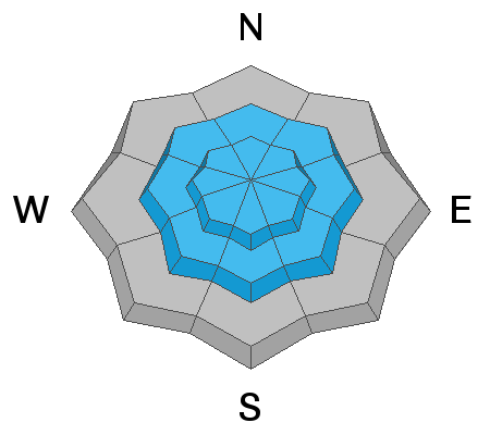
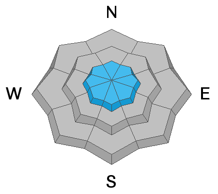
Areas of MODERATE avalanche danger exist in steep terrain at the mid and upper elevations. You will be able to trigger both shallow new snow avalanches in the mid and upper elevations and pockets of wind drifts in the higher elevations. The low elevations have a LOW avalanche danger. These avalanches are just big enough to catch and carry a person and bury them in a terrain trap.
Low
Moderate
Considerable
High
Extreme
Learn how to read the forecast here
Weather and Snow
As of 6am, skies are trending partly cloudy, but we've slowly picked up another 1-3" of low density snow overnight, pushing storm totals to 4-7". The Ogden mountains may have picked up a trace of new while the Provo mountains picked up another 6" overnight. This storm is favoring southern Utah, but we'll see some dribs and drabs this morning and another couple-few inches tonight into tomorrow. Westerly winds along the highest elevations blew 20-25mph with gusts to 35mph for a few hours, but they - and all other anemometers - are now less than 15mph. Temps have dropped into the single digits. Riding conditions are good, and best on low angle wind and sun sheltered aspects.
We'll see another few inches tonight into tomorrow. Winds will be light from the south. Temps will be in the single digits to low teens. A weak system is forecast to swing through by the end of the week.
Recent Avalanches
Shallow new snow avalanches were reported yesterday - both loose point release avalanches and shallow soft slabs 3-5" deep and 50-100' wide. These soft slabs were running on failure planes within the new snow and not (yet) along the new/old interfaces.
Meisenheimer/Champion
Ad
Avalanche Problem #1
New Snow
Type
Location
Likelihood
Size
Description
You will be able to trigger shallow avalanches in the new snow in steep terrain. Most of these will be loose snow avalanches but I wouldn't be surprised to see pockets of soft slab avalanches 3-6" deep in the upper elevations. In steep, confined terrain, these new snow avalanches will entrain all of the storm snow and may pile up deep enough to bury you.
Avalanche Problem #2
Wind Drifted Snow
Type
Location
Likelihood
Size
Description
Pockets of wind drifts can be found in the high elevation bands today. They will primarily be found on north to east to south facing slopes but all aspects are possible. These soft new wind drifts may be up to a foot or more deep in exposed terrain.
General Announcements
Who's up for some free avalanche training? Get a refresher, become better prepared for an upcoming avalanche class, or just boost your skills. Go to https://learn.kbyg.org/ and scroll down to Step 2 for a series of interactive online avalanche courses produced by the UAC.
This information does not apply to developed ski areas or highways where avalanche control is normally done. This forecast is from the U.S.D.A. Forest Service, which is solely responsible for its content. This forecast describes general avalanche conditions and local variations always occur.