Join us for the 17th Annual Professional Snow and Avalanche Workshop (PROSAW) on November 4 - Purchase tickets here!

Forecast for the Salt Lake Area Mountains

Nikki Champion
Issued by Nikki Champion on
Wednesday morning, January 12, 2022
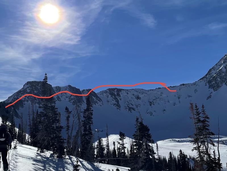
The avalanche danger is MODERATE on mid and upper elevation aspects facing west to north and east where it is possible to trigger a large and dangerous avalanche that may break down 3-10' deep and up to hundreds of feet wide.

Although all other aspects have a LOW danger, as the day heats up watch for small wet-loose avalanches in steep southerly-facing terrain and have an exit plan that allows you to quickly respond to wet snow activity.
Travel Advice: Careful snowpack evaluation, cautious route-finding, and conservative decision-making skills are still required today.
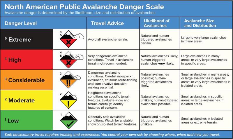
Low
Moderate
Considerable
High
Extreme
Learn how to read the forecast here
Weather and Snow
This morning, skies are clear and mountain temperatures are in the mid-20s F. Temperatures are inverted, with some low elevation trailheads in the low teens. The westerly winds at all elevations are light, averaging less than 15 mph with the occasional gust to 20 mph.
Today, skies will be sunny and temperatures will climb into the mid-30s and low 40s F at mid and upper elevations. Winds will pick up and transition more northwesterly averaging speeds of 5-15 mph at most elevations, with the occasional gust up to 35 mph at the upper elevation ridgelines.
You may still find some good riding in the lingering protected soft snow or deteriorating surface snow, but the past few days of sunshine crusted steep southerly-facing slopes and there is some wind damage along exposed ridgelines.

Hopefully, you enjoy the sunshine - as we are going to see a lot of it for a while. The next hope for any precipitation comes Friday, with the potential for a dusting of snow.
Recent Avalanches
No backcountry avalanches were reported Monday, but observations of large avalanches from this past weekend continue to roll in.
Photo of large crown seen on the north-facing aspect of the Pfeifferhorn from an avalanche failing on the facets likely occurred this past avalanche cycle between the 6th-7th. (Photo: APW)
Check out all the recent avalanches HERE.
Ad
Avalanche Problem #1
Persistent Weak Layer
Type
Location
Likelihood
Size
Description
There is a persistent weak layer (PWL) of old faceted snow near the ground with 3-10' of snow on top of it. This PWL exists on mid and upper elevation slopes facing west through north and east. It does not exist on south-facing slopes as any early season snow melted away and December snowfall landed on bare ground. This PWL has been fracturing and producing large, dangerous avalanches over the past few weeks.
These avalanches are currently tricky because they don't always offer immediate signs of instability and it's easy to be lured onto slopes with other tracks, particularly when snow depths and snow tests might be pointing in the direction of "stable".
The persistent weak layer is slowly gaining strength and adjusting to the dense, deep slab on top. We are moving farther and farther away from our last know loading event, in the form of wind loading or new snowfall, and seeing less reported avalanche activity on this layer. What this means is the likelihood that a human could trigger an avalanche that fails in the PWL is continuing to decrease, but the consequences of a deep and deadly avalanche still remain high. This remains particularly possible in areas that the slab atop the facets is thinner, such as steep rocky terrain where the overall snowpack is shallower or on an old repeater slope that still has facets at the ground. While we are trending in the right direction and getting closer to an overall LOW danger, we are not out of the woods yet, and I would continue to be cautious of traveling on or below steep west through north through east facing slopes.

Photos from the Park City Ridgeline that show that the facets at the ground are beginning to round, but the poor snowpack structure still very much exists. (Photos: Weston Shirey)
Additional Information
On Sunday, Trent walked you through the decision-making process of determining whether the PWL problem is Moderate or Considerable based upon the Avalanche Danger Scale (shown below). I encourage you to re-read that forecast as it provides some insight into the decision-making process of assigning a danger rating.
General Announcements
Who's up for some free avalanche training? Get a refresher, become better prepared for an upcoming avalanche class, or just boost your skills. Go to https://learn.kbyg.org/ and scroll down to Step 2 for a series of interactive online avalanche courses produced by the UAC.
This information does not apply to developed ski areas or highways where avalanche control is normally done. This forecast is from the U.S.D.A. Forest Service, which is solely responsible for its content. This forecast describes general avalanche conditions and local variations always occur.