Join us for the 17th Annual Professional Snow and Avalanche Workshop (PROSAW) on November 4 - Purchase tickets here!

Forecast for the Salt Lake Area Mountains

Trent Meisenheimer
Issued by Trent Meisenheimer on
Sunday morning, January 9, 2022
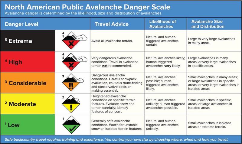
Dense storm and wind-drifted snow have created a CONSIDERABLE avalanche danger on mid and upper elevation aspects facing west to north and east. Avalanches may break down 3-10 feet deep into old, weak snow near the ground. Dangerous avalanche conditions do exist.
For now, I'm still avoiding steep slopes on the north half of the compass until I see the weak snow near the ground gain some more strength.

Generally, safe avalanche conditions and LOW avalanche danger can be found on the southerly facing terrain and slopes below 8,000'.
Low
Moderate
Considerable
High
Extreme
Learn how to read the forecast here
Weather and Snow
Under clear skies, the mountain temperatures range from 10° to 15° F at the mid and upper elevations. Winds are blowing from the west at speeds of 5-10 mph across the upper ridgelines. Plenty of sunshine on tap for today, and it should be an epic day to be in the mountains.
The snow surfaces do vary out there. Lower elevations will support a crust with a few inches of fluff on top. High-elevations will have some wind damage. Mid to upper-elevation northerly sheltered slopes provide excellent, cold, dry powder. Some mid-elevation southerly facing slopes will have a slight crust this morning from yesterday's sun peaking through the clouds.
Recent Avalanches
One avalanche was triggered with explosives yesterday in upper Little Cottonwood Canyon. It was on a northwest-facing slope at 9,700' in elevation. The avalanche was 5 to 7 feet deep 200 feet wide and ran 600 feet downhill and failed on weak faceted snow near the ground.
Our Week in Review - where we highlight significant snow and weather events - has been published.
Ad
Avalanche Problem #1
Persistent Weak Layer
Type
Location
Likelihood
Size
Description
There is a persistent weak layer (PWL) of old faceted snow near the ground with 3-10' of snow on top of it. This PWL exists on mid and upper elevation slopes facing west through north and east. It does not exist on south-facing slopes as any early season snow melted away, and December snowfall landed on bare ground. This PWL has been fracturing and producing large, dangerous avalanches over the past few weeks. I would continue to avoid steep slopes on the north half of the compass. Head to the southerly (sunny) slopes if you want to ride steep terrain.
Ok, let us pick a danger rating together: Let's decide between CONSIDERABLE vs. MODERATE. Please start with the (Travel Advice) column. Think about the consequence and size of the avalanches right now and how we would need to move in the mountains. I think the travel advice fits better for CONSIDERABLE vs. MODERATE as we have dangerous avalanche conditions, and I would be cautious and conservative.
Next column (Likelihood of Avalanches), we've seen the frequency (the number of avalanches) decrease over the past few days. The weak layer is now buried deep, and therefore it's harder for us to affect that weak layer. For that reason, I think the Likelihood of human-triggered avalanches is possible and NOT likely. I think MODERATE works better here. Think of it in odds. You now have a 2 out of 10 chance vs. an 8 out of 10 chance of triggering an avalanche. The Likelihood has decreased, but the consequence remains the same. Drew Hardesty has a video explaining this HERE.
Finally, the (Avalanche Size & Distribution), I don't think large avalanches only exist in isolated areas. In fact, there is a very specific terrain where you can trigger a large or very large avalanche. And we know that's on slopes that face west to north to east at the mid and upper elevations. Therefore I think the Avalanche Size & Distribution fits better for CONSIDERABLE vs. MODERATE.
At the start of the morning, it's tough determining what the actual danger rating is, especially, when everything doesn't fit nicely into the North American Danger Scale. However, two out of the three columns match better to CONSIDERABLE so I am sticking with that.
Additional Information
Caitlin Hansen, Drew, Craig, and Nikki discuss the current danger rating, dealing with the persistent weak layers, and the problem moving forward this season.
General Announcements
Who's up for some free avalanche training? Get a refresher, become better prepared for an upcoming avalanche class, or just boost your skills. Go to https://learn.kbyg.org/ and scroll down to Step 2 for a series of interactive online avalanche courses produced by the UAC.
This information does not apply to developed ski areas or highways where avalanche control is normally done. This forecast is from the U.S.D.A. Forest Service, which is solely responsible for its content. This forecast describes general avalanche conditions and local variations always occur.