Join us for the 17th Annual Professional Snow and Avalanche Workshop (PROSAW) on November 4 - Purchase tickets here!

Forecast for the Salt Lake Area Mountains

Trent Meisenheimer
Issued by Trent Meisenheimer on
Saturday morning, January 8, 2022
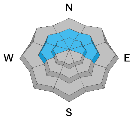
Dense storm and wind-drifted snow have created a CONSIDERABLE avalanche danger on mid and upper elevation aspects facing west to north and east. Avalanches may break down 3-10 feet deep into old, weak snow near the ground. A MODERATE avalanche danger exists on southerly aspects at the mid and upper elevations for both hard and soft drifts of wind-blown snow.

The good news is that we can find excellent and safer riding on lower-angle slopes with no overhead hazard.
Low
Moderate
Considerable
High
Extreme
Learn how to read the forecast here
Weather and Snow
It's been snowing since about midnight, with 2-4 inches of new snow (0.20-0.32 water) recorded at 5:00 am this morning. This quick-hitting cold front has already moved through the mountains, and the snow will turn to light showers by about sunrise. The good news is this cold front dropped the mountain temperatures, and the winds have relaxed a bit. High pressure will build into the area later today and Sunday should be a stunner!
Current mountain temperatures range 16°-20° F at the mid and upper elevations. Down lower in the canyons, the temperatures range 25°-30° F. Winds blow from the west-northwest 10-15 mph gusting into the 30's along the exposed upper elevation ridges.
It's been a good run for us here in the Wasatch, and storm totals from the past few days may have modest snow amounts, but impressive water (Snow Water Equivalent, or SWE) numbers:
Little Cottonwood 24"/4.07"
Big Cottonwood 19"/2.9"
Park City Ridgeline 13"/2.6"
Recent Avalanches
It's been a wild week for recent avalanche activity, and you should check out the observations and avalanches tab found here. We had one avalanche reported yesterday: a hard wind slab avalanche 8" deep 100' wide on a southeast-facing slope at 9,100'.
Our Week in Review - where we highlight significant snow and weather events - has been published.
Ad
Avalanche Problem #1
Persistent Weak Layer
Type
Location
Likelihood
Size
Description
There is a persistent weak layer (PWL) of old faceted snow near the ground with 3-10' of snow on top of it. This PWL exists on mid and upper elevation slopes facing west through north and east. It does not exist on south-facing slopes as any early season snow melted away, and December snowfall landed on bare ground. This PWL has been fracturing and producing large, dangerous avalanches over the past few weeks. Since Wednesday, we have added 1-2' of dense snow containing up to 4" of water weight as well as wind-loaded snow- stressing this buried weak layer.
Drew Hardesty explains how we are moving in the right direction towards this PWL problem becoming dormant. However, we still haven't had a day where we aren't loading (adding weight) to our snowpack. So, for now, I will continue to avoid being on or underneath any steep slopes facing west/north/east at the mid and upper elevations for at least the next few days.
Avalanche Problem #2
Wind Drifted Snow
Type
Location
Likelihood
Size
Description
Over the past few days, strong southwest winds have created hard and soft drifts of wind-blown snow at the mid and upper elevations. Yesterday's avalanche on the Cone is a good example of this problem. Unfortunately, the 2-4 inches of new snow has likely covered these textured drifts, making them harder to see. But, as always, look for and avoid rounded pillowy snow or stiff/firm snow that sounds hollow like a drum.
Any wind drifted snow avalanche triggered on slopes facing west to north to east at the mid and upper elevations may step down, triggering a much larger and more dangerous avalanche that fails on a buried persistent weak layer (see avalanche problem 1 above).
Additional Information
Caitlin Hansen, Drew, Craig, and Nikki discuss the current danger rating, dealing with the persistent weak layers, and the problem moving forward this season.
General Announcements
Who's up for some free avalanche training? Get a refresher, become better prepared for an upcoming avalanche class, or just boost your skills. Go to https://learn.kbyg.org/ and scroll down to Step 2 for a series of interactive online avalanche courses produced by the UAC.
This information does not apply to developed ski areas or highways where avalanche control is normally done. This forecast is from the U.S.D.A. Forest Service, which is solely responsible for its content. This forecast describes general avalanche conditions and local variations always occur.