Join us for the 17th Annual Professional Snow and Avalanche Workshop (PROSAW) on November 4 - Purchase tickets here!

Forecast for the Salt Lake Area Mountains

Greg Gagne
Issued by Greg Gagne on
Friday morning, December 31, 2021
Updated 8:30 AM. We're heard a report of "historic" avalanches in the Cottonwoods and we updating this morning's forecast to include a Considerable danger at Low elevations (below 8,000')
The avalanche danger is HIGH at the upper elevations as well as mid elevation slopes facing west through north and east. Avalanche conditions are dangerous and travel in avalanche terrain is not recommended on these slopes. Avalanches may break down 4-6' deep (possibly deeper) and several hundred feet wide.
Mid elevations facing southwest/south/southeast and Low elevations have a CONSIDERABLE avalanche danger.

The good news is that the dense snowfall and cold temperatures has created excellent riding and travel conditions on lower-angled southerly-facing slopes.
Low
Moderate
Considerable
High
Extreme
Learn how to read the forecast here
Avalanche Warning
AN AVALANCHE WARNING HAS BEEN ISSUED FOR THE MOUNTAINS OF MUCH OF THE STATE OF UTAH, INCLUDING THE WASATCH RANGE...BEAR RIVER RANGE...UINTA MOUNTAINS...THE MANTI-SKYLINE ...THE FISH LAKE REGION…PAHVANTS…TUSHARS…AND THE CEDAR CITY AREA MOUNTAINS.
THE AVALANCHE DANGER IS HIGH FOR THE WARNING AREA AND TRAVEL IN AVALANCHE TERRAIN IS NOT RECOMMENDED.
HEAVY SNOWFALL AND STRONG WINDS HAVE CREATED VERY DANGEROUS AVALANCHE CONDITIONS. BEING CAUGHT IN ANY AVALANCHE IS LIKELY TO BE UNSURVIVABLE. STAY OFF OF AND OUT FROM UNDER SLOPES STEEPER THAN 30 DEGREES.
Weather and Snow
Thursday featured very strong west/southwest winds and heavy snowfall began in the early evening hours. As of 5 am, 24-hour snowfall totals are 14-22" containing 1.5" to over 2" of water. This is a rapid loading event!
Temperatures range throughout the teens and winds are from the west/southwest and have diminished somewhat. At lower elevation ridges, wind speeds are averaging less than 10 mph with gusts in the 20's. Mid elevation ridges are averaging in the teens with gusts in the 20's mph. Along the upper-most ridges winds remain elevated, averaging in the 20's and 30's with overnight gusts in the 60's and 70's mph.
For today, temperatures will stay stuck in the teens with another 4-8" of snowfall. Winds will be from the west/northwest. At mid elevations winds will average in the teens with gusts in the 20's mph. At the highest ridges, winds will average in the 20's and 30's with gusts near 50 mph.
Snowfall may pick up again overnight and into Saturday morning, followed with the coldest temperatures thus far of this winter season.

Our Week in Review - where we highlight significant snow and weather from the past week - is now available.
Recent Avalanches
There were likely at least a few natural avalanche cycles during the overnight hours during periods of heavy precipitation.

There was a report of a remotely-triggered avalanche near the Red Cliffs area adjacent to Squaretop. This avalanche was reported up to 5' deep and 250' wide and occurred on Wednesday.
On Thursday, a 
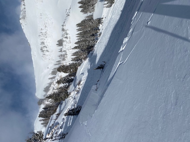
natural avalanche was reported near Pointy Peak along the Park City ridgeline. The avalanche from Thursday that caught my attention was a natural avalanche in Butler Basin (photo below) that likely occurred sometime early Thursday morning. This was on a northeast aspect at 9,300' and was up to 4' deep and an estimated 400-500' wide. It is possible strong winds on Thursday morning overloaded this slope.
Ad
Avalanche Problem #1
Persistent Weak Layer
Type
Location
Likelihood
Size
Description
Strong winds and heavy snowfall since Thursday have rapidly overloaded the weak faceted snow that is found on mid and upper elevation aspects facing west through north and east. This layer of faceted snow is 6-12" thick and found down at the ground. Snowfall and wind from the past eight days has now buried this weak layer under 4-6' of snow. There may be fewer signs of instability that disguise this dangerous weakness - fewer collapses and cracking. But if you do trigger an avalanche where this persistent weak layer (PWL) is present - perhaps from a thinner spot on the slope or on a steeper convex rollover - the avalanche will break down 4-6' deep (possibly deeper) and up to hundreds of feet wide. Unsurvivable.
In the past eight days, the central Wasatch has received 4-7" of water weight. On slopes where the PWL is present, this load has put a significant strain on this weak layer. We are moving in the right direction and ultimately the load of snow this past week should help settle the PWL problem, but for now your continued patience is required.
Avalanche Problem #2
New Snow
Type
Location
Likelihood
Size
Description
Storm totals of 1-2' over the past 24 hours will create sensitive soft slabs of new snow on all aspects. Periods of heavier precipitation are possible today - especially during the morning hours. Expect the new snow to be sensitive during any period of higher precipitation intensity and watch for rapidly changing conditions.
Avalanche Problem #3
Wind Drifted Snow
Type
Location
Likelihood
Size
Description
Although winds have diminished somewhat since Thursday (which Drew accurately described as "Unceasing powerful southwesterly winds"), winds are still strong enough to move snow. With lower-density snowfall forecast for today, it will be possible for fresh wind drifts to form on all aspects at the mid and upper elevations.
Also - cornices have grown quite large over the past few days and they may overhang well over ridgelines. Give yourself a wide berth and do not travel close to ridgelines where cornices may be present. Any cornice fall - natural or intentional - may trigger a large avalanche on the slope below.
Additional Information
On Thursday evening, UAC forecasters from across the state gathered on Zoom to discuss the current avalanche danger and what we expect this coming weekend.
General Announcements
Who's up for some free avalanche training? Get a refresher, become better prepared for an upcoming avalanche class, or just boost your skills. Go to https://learn.kbyg.org/ and scroll down to Step 2 for a series of interactive online avalanche courses produced by the UAC.
This information does not apply to developed ski areas or highways where avalanche control is normally done. This forecast is from the U.S.D.A. Forest Service, which is solely responsible for its content. This forecast describes general avalanche conditions and local variations always occur.