Forecast for the Salt Lake Area Mountains

Greg Gagne
Issued by Greg Gagne on
Saturday morning, January 1, 2022
The avalanche danger is HIGH on mid and upper elevation slopes facing west through north and east and travel in avalanche terrain is not recommended on these slopes. Avalanches may break down 4-6' deep (possibly deeper) and hundreds of feet wide.
Upper elevation slopes facing southwest/south/southeast have a CONSIDERABLE avalanche danger. All low elevations and mid elevation slopes facing southwest/south/southeast have a Moderate avalanche danger.

The good news is that recent snowfall and cold temperatures have created excellent riding and travel conditions on lower-angled southerly-facing slopes. (Plus, it's going to be a lot warmer in the sun!)
Low
Moderate
Considerable
High
Extreme
Learn how to read the forecast here
Avalanche Warning
AN AVALANCHE WARNING HAS BEEN ISSUED FOR THE MOUNTAINS OF MUCH OF THE STATE OF UTAH, INCLUDING THE WASATCH RANGE...BEAR RIVER RANGE...UINTA MOUNTAINS...THE MANTI-SKYLINE ...THE FISH LAKE REGION…PAHVANTS…TUSHARS…AND THE CEDAR CITY AREA MOUNTAINS.
THE AVALANCHE DANGER IS HIGH FOR THE WARNING AREA AND TRAVEL IN AVALANCHE TERRAIN IS NOT RECOMMENDED.
HEAVY SNOWFALL AND STRONG WINDS HAVE CREATED DANGEROUS AVALANCHE CONDITIONS. BEING CAUGHT IN ANY AVALANCHE IS LIKELY TO BE UNSURVIVABLE. STAY OFF OF AND OUT FROM UNDER SLOPES STEEPER THAN 30 DEGREES.
Weather and Snow
Currently: Temperatures range from -5° to +5° F but fortunately the west/northwest winds are light at the low and mid elevation ridges, averaging less than 10 mph with gusts in the teens. Along the highest ridges, winds are quite different with hourly averages in the 20's mph and gusts in the upper 30's mph, creating wind chills right around -30° F. Snowfall totals since Thursday night range from 18-24" (containing 1.2 - 2.2" water) along the Park City ridgeline and the Cottonwoods.
Water totals in the Cottonwoods since 12/23 are 8" - a significant loading event!
Today: Skies will be partly cloudy and temperatures will be the coldest of this winter season so far, rising only into the low single digits. Winds will be from the northwest and mercifully light to moderate, averaging around 10 mph with gusts in the teens along low and mid elevation ridgelines and summits. Along the highest ridges wind speeds will be somewhat stronger with hourly averages around 20 mph and gusting into 20's and low 30's mph.
Looking ahead, temperatures will warm Sunday into Monday with sunshine. A return to a progressive weather pattern is expected with additional snowfall by midweek.
Recent Avalanches
Our Week in Review has been published.

Several avalanches were reported from the backcountry and control work at resorts:
Reynolds East Face
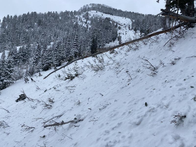
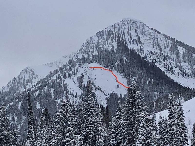
Kessler Slabs - Northeast-facing at 9,200' breaking down 2-3' and up to 700' wide, nearly reaching the base of the summer road. (Photos Laurie MacMillan and UDOT)
Control work from Cottonwood resorts produced very large avalanches breaking down into old snow, with some crowns estimated up to 10' deep. The avalanche that really caught my attention was from control work prior to resort opening at Alta producing an avalanche on Mount Baldy that was described as "historic". There is a nearly 80 year history of avalanche mitigation in Little Cottonwood and when the term historic is used it's worthy of our attention.
Ad
Avalanche Problem #1
Persistent Weak Layer
Type
Location
Likelihood
Size
Description
Over the past week we have added several feet of snow (with up to 8" of water) to our snowpack. In addition, several wind events with strong winds from the west/southwest have deposited dense slabs of wind-driven snow at the mid and upper elevations. This new snow and dense wind slabs have created dangerous avalanche conditions on mid and upper elevation slopes facing west through north and east where there is a persistent weak layer (PWL) of faceted snow down near the ground. Avalanches over the past few days have broken down to this weak layer, producing slides up to 10' deep and hundreds of feet wide.
This dangerous weakness may be disguised with none of the typical signs of instability such as cracking and collapsing. But if you do trigger an avalanche where this persistent weak layer (PWL) is present - perhaps from a thinner spot on the slope or on a steeper convex rollover - the avalanche will break down 4-6' deep (possibly deeper) and up to hundreds of feet wide. Unsurvivable.
We are moving in the right direction and ultimately the load of snow this past week should help settle the PWL problem, but for now your continued patience is required.
Avalanche Problem #2
New Snow
Type
Location
Likelihood
Size
Description
Instabilities from the 18-24" of new snow from the New Year's Eve storm are likely to have settled out, but you may find areas with pockets of dense snow that may be reactive, especially in exposed terrain where the new snow may have been drifted by winds. Sluffing in the new snow is also possible on steeper slopes.
What most concerns me are the northerly-facing slopes where this new snow has added stress to the deeply-buried PWL.
Additional Information
On Thursday evening, UAC forecasters from across the state gathered on Zoom to discuss the current avalanche danger and what we expect this coming weekend.
General Announcements
Who's up for some free avalanche training? Get a refresher, become better prepared for an upcoming avalanche class, or just boost your skills. Go to https://learn.kbyg.org/ and scroll down to Step 2 for a series of interactive online avalanche courses produced by the UAC.
This information does not apply to developed ski areas or highways where avalanche control is normally done. This forecast is from the U.S.D.A. Forest Service, which is solely responsible for its content. This forecast describes general avalanche conditions and local variations always occur.