Forecast for the Salt Lake Area Mountains

Trent Meisenheimer
Issued by Trent Meisenheimer on
Sunday morning, January 2, 2022
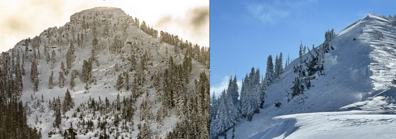
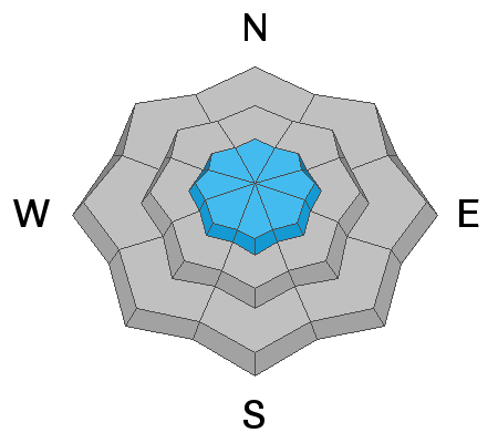
The avalanche danger is CONSIDERABLE on mid and upper elevation slopes facing west through north and east. Avalanches may break down 4-6' deep (possibly deeper) and hundreds of feet wide. Natural avalanches are possible, and human-triggered avalanches are likely. My advice is to continue avoiding this terrain.
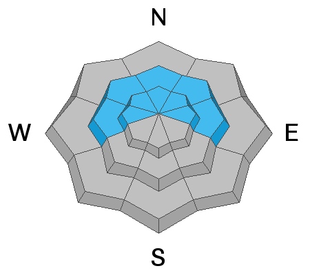
Upper elevation slopes facing southwest, south, and southeast have a MODERATE avalanche danger for wind-drifted snow avalanches. My advice would be to stick to the southerly (sunny) side of the mountain, where there is excellent powder and no buried weak layer.
Low
Moderate
Considerable
High
Extreme
Learn how to read the forecast here
Weather and Snow
Under clear skies, the mid to upper elevation mountain temperatures range from 5° to 15° F this morning. Down in the valley bottoms and lower trailhead drainages, the temperature is -8° to 0° F. Winds are from the west-northwest and are blowing 5-15 mph with gusts into the low to mid 20's across the upper elevation ridgelines.
Today, we will have plenty of sunshine with daytime temperatures climbing into the mid-twenties °F. Wind will back to the west-southwest and should stay behaved with speeds 5-15 mph. It's nice seeing the sun, and it's amazing how plastered the mountains are! But don't get too used to the sun. Starting Tuesday morning, we enter another stormy period with more snow on the way.
Recent Avalanches
Ski areas continue to produce large and deep avalanches with explosives. One result on the Park City Ridge was 3-4 feet deep, 200 feet wide, breaking on faceted snow. In the backcountry, photos continue to pour into the observations & avalanches tab on the website showing the extent of the avalanches that ran naturally over the past few days. These avalanches that are being reported are generally 3 to 8 feet deep and hundreds of feet wide, breaking to old-faceted snow near the ground. Be sure to check out all the observations and photos HERE.
Our Week in Review has been published.
Photo: The left-hand image shows a large natural avalanche on Kessler Peak. The Right-hand image shows large natural avalanches off Scott's Peak on the Park City Ridgeline.
Ad
Avalanche Problem #1
Persistent Weak Layer
Type
Location
Likelihood
Size
Description
Over the past week, we have added several feet of snow (with up to 8" of water) to our snowpack. In addition, strong winds from the west/southwest have deposited dense slabs of wind-driven snow at the mid and upper elevations. This new snow and dense wind-driven snow have created dangerous avalanche conditions on mid and upper elevation slopes facing west through north and east, where there is a buried persistent weak layer (PWL) of faceted snow. Over the past few days, large avalanches have broken down to this weak layer, producing slides up to 3 to 10 feet deep and hundreds of feet wide.

Choose the type of avalanche problem you want to deal with. You have two options. You can choose to ride the southerly (sunny) facing terrain where you need to look out for small drifts of wind-blown snow (see second avalanche problem). OR your second option is to ride slopes on the northerly (shady) facing terrain where you are likely to trigger large, deep, wide, scary, deadly, tree snapping avalanches that will likely KILL you. My advice is below:
  • Avoid this problem entirely by sticking to the southerly facing terrain with no buried weak layer.
  • Southerly facing terrain has all-time powder and no weak layer and therefore is a much safer riding option.
  • Temperatures are cold - why ride in the icebox when the southerly facing sunshine keeps you warm.
  • If you decide to ride northerly facing terrain, stick to slopes under 30° degrees in steepness with nothing steep above you.
Avalanche Problem #2
Wind Drifted Snow
Type
Location
Likelihood
Size
Description
Overnight the winds have been well behaved for all but the uppermost elevations where the wind is blowing from the north-west at speeds of 10-15 mph. However, with so much new snow available for transport, it's hard not to think there will be some pockets of wind drifted snow off the ridgelines. As always, be on the lookout and avoid the snow that looks wavy, rounded, and pillowy.
Any cornice or wind drifted snow avalanche that's triggered on the northerly side of the compass has the potential to step down into deeper weaker layers triggering a much larger avalanche.
General Announcements
Who's up for some free avalanche training? Get a refresher, become better prepared for an upcoming avalanche class, or just boost your skills. Go to https://learn.kbyg.org/ and scroll down to Step 2 for a series of interactive online avalanche courses produced by the UAC.
This information does not apply to developed ski areas or highways where avalanche control is normally done. This forecast is from the U.S.D.A. Forest Service, which is solely responsible for its content. This forecast describes general avalanche conditions and local variations always occur.