31st Annual Backcountry Benefit - September 12th - Tickets Available Here!

Forecast for the Salt Lake Area Mountains

Mark Staples
Issued by Mark Staples on
Monday morning, January 3, 2022
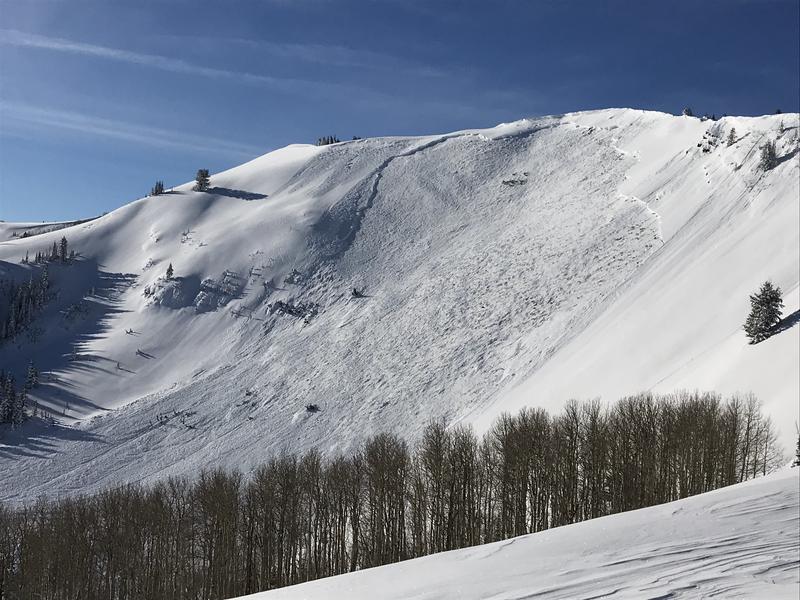
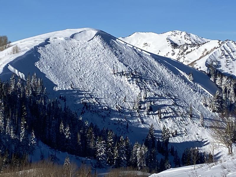
The avalanche danger is CONSIDERABLE on mid and upper elevation slopes facing west through north and east. Avalanches may break down 4-6' deep (possibly deeper) and hundreds of feet wide. Natural avalanches are possible, and human-triggered avalanches are likely. Avoid this terrain because those avalanches will kill you.
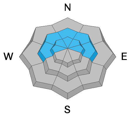
Watch for any freshly formed wind drifts on slopes facing southwest, south, and southeast which have a MODERATE avalanche danger at upper elevations and a LOW danger at mid and low elevations.
Low
Moderate
Considerable
High
Extreme
Learn how to read the forecast here
Weather and Snow
Temperatures this morning are in the upper teens to low 20s F although a few trailheads have a pool of cold air in the single digits F. Overnight, winds increased some from the south, not a huge amount, but enough to likely transport snow. They are blowing 15-20 mph gusting 30 mph. In a few locations, winds are blowing from the south-southeast.
Today temperatures will generally rise to the upper 20s F, but lower elevation locations should have temperatures in the mid 30s F. High clouds will gradually increase through the day. Winds will increase some and continue blowing from the south and southwest.
Snowfall returns tomorrow late morning. Heavier snowfall arrives Wednesday morning to Thursday morning. This storm looks like it will have strong winds, increasing temperatures, and increasing snow densities.

Strong sunshine yesterday warmed the snow on south facing slopes and some should have a slight crust this morning. Coverage is fantastic, and settled snow depths, even at lower elevations are 3-4 feet. Upper elevation areas and the upper cottonwoods have snow depths up to 6-7 feet.
Recent Avalanches
To be honest, there has been so much avalanche activity that it's hard to keep track of it all. The thing to know about recent avalanches is that they have all been very large, deadly avalanches mostly on north, northeast, and east facing slopes. There were two notable avalanches yesterday. One in West Monitor along the Park City Ridgeline, and another on Little Water Peak in between Big Cottonwood and Mill Creek Canyons. Ski areas triggered similar slides with explosives including one caught on video at Alta Ski Area.
View all the recent avalanche activity HERE.
West Monitor Avalanche, 6 ft deep, 700+ ft wide, east facing at 10,000 ft in elevation.
Little Water Peak avalanche, 6 ft deep, 800 ft wide, northeast facing at 9500 ft in elevation.
Ad
Avalanche Problem #1
Persistent Weak Layer
Type
Location
Likelihood
Size
Description
The situation is very simple - there is a persistent weak layer (PWL) of old, faceted snow near the ground with 3-10 feet of snow on top of it. This layer has been fracturing and producing avalanches, and I wouldn't be at all surprised to hear of more today. Winds increased from the south and have likely been loading the slopes where this PWL exists. The likelihood of triggering these massive avalanches has gone down just a little in recent days, but the size and destructive potential of these slides hasn't changed.
This layer exists on west, north, and east-facing slopes where old snow lingered and weakened in November and was buried by December snowfall. It doesn't exist on south-facing slopes because it melted away in November, and December snowfall landed on bare ground on those slopes.
Over the last week, snowfall containing up to 8 inches of water has been added to the snowpack. We focus on water amounts because that tells us how much weight is added to the snowpack. For a slope the size of a football field, snow with 8 inches of water weighs 2,800,000 pounds. Imagine that amount of snow crashing downhill.

How will we know when this avalanche problem heals? That's a tough question to answer, and we mainly have to let the snowpack answer it. For now, avalanches are still happening and that's all I need to know. As we look into the future, it will heal, but I can't tell you when. We will be monitoring the snowpack and avalanche activity and keep you updated.
Avalanche Problem #2
Wind Drifted Snow
Type
Location
Likelihood
Size
Description
This morning, south winds increased some and have likely been transporting snow. For the snowpack, when the winds drift snow, it's the same as if snow is falling out of the sky. The snowpack doesn't care where the snow comes from, it feels the added weight. So, on northerly facing slopes, these winds have added snow and weight and stress to the avalanche problem listed above.
While these south winds have mostly formed drifts on northerly facing slopes, they can load any slope because winds swirl and change direction as they pass through the mountains.
What to do? Avoid any steep west, north, or east facing terrain that has avalanche problem listed above. If riding south facing avalanche terrain, look for evidence of fresh drifts and wind slabs that look wavy, rounded, smooth, and pillowly and avoid them as well. Fortunatley, those fresh drifts are easy to see and go around.
General Announcements
Who's up for some free avalanche training? Get a refresher, become better prepared for an upcoming avalanche class, or just boost your skills. Go to https://learn.kbyg.org/ and scroll down to Step 2 for a series of interactive online avalanche courses produced by the UAC.
This information does not apply to developed ski areas or highways where avalanche control is normally done. This forecast is from the U.S.D.A. Forest Service, which is solely responsible for its content. This forecast describes general avalanche conditions and local variations always occur.