Join us for the 17th Annual Professional Snow and Avalanche Workshop (PROSAW) on November 4 - Purchase tickets here!

Forecast for the Salt Lake Area Mountains

Nikki Champion
Issued by Nikki Champion on
Thursday morning, December 30, 2021
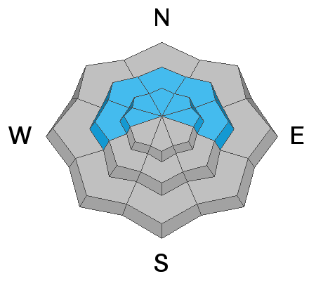
The avalanche danger is HIGH on upper elevation aspects facing northwest through north and east, where strong winds and recent snowfall have created dangerous avalanche conditions. Upper elevation aspects facing west and mid-elevation aspects facing west through north through east - have a CONSIDERABLE danger. Natural and human-triggered avalanches are likely. Any natural or human-triggered avalanche can be 2-6' deep, over a few hundred feet wide, and likely unsurvivable.
Pay attention to changing weather patterns, as this storm intensifies avalanche danger will rapidly rise.
Traveling on, underneath, or adjacent to slopes steeper than 30° at the upper elevations is not recommended. Fortunately, there are excellent riding conditions on lower-angled slopes outside of wind-affected terrain.
Low
Moderate
Considerable
High
Extreme
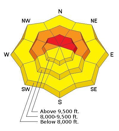
Learn how to read the forecast here
Special Announcements
There will be avalanche mitigation work taking place near the Jupiter Peak area and chairlift. PLEASE stay clear of the ridgeline and the Scott's Pass runnout zone.
Weather and Snow
Under mostly cloudy skies, snow continues to fall in the mountains. Current mountain temperatures are in the mid-teens to low 20s °F. The winds picked up overnight, and are blowing from the west-southwest at speeds of 15-20 mph with mid elevation gusts up to 35 mph and upper elevation gusts near 80 mph. In the last 24 hours, the mountains have picked up 4"-11" of new snow. Last night's snowfall favored upper Big Cottonwood Canyon with close to 10" of snowfall.
Today will be overcast with intermittent snow throughout the day. We can expect another 2-4" of snow on the ground before dinner. Snowfall should really begin intensifying this afternoon, and into the evening with 13-24" of snow possible by tomorrow morning, and periods of 2" snow per hour. Temperatures will climb into the mid-20s °F. Winds will remain elevated all day and continue to increase into the evening. The west-southwesterly winds will blow at speeds of 20-30 mph with occasional gusts up to 35 mph at mid-elevations, and 50 mph at upper elevations.
Recent Avalanches
No new avalanches were reported in the backcountry yesterday.
Ad
Avalanche Problem #1
Persistent Weak Layer
Type
Location
Likelihood
Size
Description
Heavy snowfall and strong winds continue to overload a buried persistent weak layer of faceted snow down near the ground. This layer exists on mid and upper elevation aspects facing west through north and east. Any avalanche failing on this layer may break down 2-6' deep (possibly deeper), propagate hundreds of feet wide, and run downhill thousands of feet. No matter the avalanche danger, the consequences remain the same; these are large, deadly, and destructive avalanches.
A few words of caution:
  • Pay attention to changing conditions, if this storm comes in early the avalanche danger will rapidly rise. Spike in precipitation = Spike in danger.
  • Obvious signs of instability may not be present today: you may or may not see or experience shooting cracks or audible whumping. The danger still exists.
  • Tracks on the slope offer zero signs of stability. Avalanches will take out multiple existing tracks.
  • You can trigger these avalanches remotely (from a distance) or from below. Give ridgetops a wide berth.
  • Any fresh wind slab or new snow avalanche may step down into this older layering of weak snow.

While we haven't been seeing as many obvious signs of instabilities like cracking, collapsing, and recent avalanche activity. This avalanche danger still very much exists. When avalanche danger may not seem as obvious, I fear that people may push out onto steeper west through north through east-facing slopes, get away with it, and think that we are in the clear. We are not in the clear. This avalanche problem is the real deal and should be avoided with large safety margins. Avoidance is the key.
UAC Observer and Guide Cody Hughes talks about the decrease in obvious signs of instability, but still evident poor snowpack structure on Sheep S*%t Ridge. Find his full observation HERE.
Avalanche Problem #2
Wind Drifted Snow
Type
Location
Likelihood
Size
Description
After what felt like only a short intermission in the brutal Southwesterly winds, ridgeline gusts are already back to 75 mph.
Strong winds will continue to create both hard and soft slabs of windblown on all aspects at the mid and upper elevations. Although the winds have been mainly from the west/southwest, winds this strong can channel snow around terrain features and create fresh drifts on all aspects, including well-down off of ridge lines. You may even find fresh wind drifts at unusually low elevations below 8,000'.

Today look for slopes with any signs of wind drifted snow, such as cracking, hollow noises, and pillow-shaped snow, and avoid those slopes.
Additional Information
Craig Gordon, Mark Staples, Trent Meisenheimer, Toby Weed, and Brett Kobernik discuss the current avalanche situation. They discuss some things we know and some things we don't know.

General Announcements
Who's up for some free avalanche training? Get a refresher, become better prepared for an upcoming avalanche class, or just boost your skills. Go to https://learn.kbyg.org/ and scroll down to Step 2 for a series of interactive online avalanche courses produced by the UAC.
This information does not apply to developed ski areas or highways where avalanche control is normally done. This forecast is from the U.S.D.A. Forest Service, which is solely responsible for its content. This forecast describes general avalanche conditions and local variations always occur.