Forecast for the Moab Area Mountains

Eric Trenbeath
Issued by Eric Trenbeath on
Sunday morning, February 7, 2021
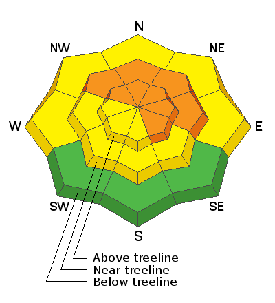
The avalanche danger remains CONSIDERABLE near treeline and above on steep slopes facing NW-NE-SE and deep and dangerous human triggered avalanches failing on a buried persistent weak layer are likely in these areas. Easterly facing slopes with recent deposits of wind drifted snow are the most suspect. Avalanches can be triggered from a distance and break wider and farther than expected. A MODERATE avalanche danger exists below treeline. Generally, LOW danger can be found on low elevation, south-facing terrain.
Low
Moderate
Considerable
High
Extreme
Learn how to read the forecast here
Special Announcements
We are filled with grief to report four fatalities from a skier triggered avalanche in the Wasatch Mountains yesterday. All were well known members of the backcountry community. Here is the preliminary report. In a little over a week, there have been 14 avalanche fatalities across the U.S. Conditions are dangerous in most regions and ours is no exception. Please stay conservative in your terrain choices.

The Geyser Pass Road is plowed. Conditions are snow-packed and icy and all-wheel drive is recommended.
The Lower Utah Nordic Alliance (LUNA) groomed all trails yesterday and Matt says that conditions are perfect!
Weather and Snow
24 Hour Snow 0" 72 Hour Snow 0" Base Depth in Gold Basin 40" Wind WNW 10-20 Temp 18F
Moderate WSW winds overnight shifted back to the WNW early this morning. Skies will be mostly sunny today with light to moderate westerly winds. High temps at 10,000' will be near 30F. We'll see a slight increase in southwesterly winds tomorrow with temperatures in the low 30's. Tues and Wed look to be cloudy with a very slight chance of a few flakes on Wednesday. Mostly sunny skies return for the remainder of the week.
Wind, temperature, humidity on Pre Laurel Peak (11,700')
Snotel site near Geyser Pass Trailhead (9600')
Storm totals at the Gold Basin study plot (10,000')
Snowpack Discussion
It's now been a week since our last significant snowfall and conditions are variable. Warm temperatures have settled and consolidated last week's storm snow and the surface is tired and worn. On sunny aspects, the snow surface has crusted over. Moderate SW-NW winds have scoured exposed, windward slopes while alternately loading leeward, easterly facing slopes. On NW-N-E aspects, dangerous slabs 2'-3' deep are perched above the weak underlying snowpack. These slabs are growing more stubborn by the day but they remain primed and ready for human triggers.
Chris Benson did a flyover of both the La Sal and Abajo mountains yesterday. He submitted this observation and shot the following aerial footage.
Recent Avalanches
In his aerial travels yesterday, Chris Benson noted this fairly recent avalanche in Beaver Basin though the actual date is unknown.
Ad
Avalanche Problem #1
Persistent Weak Layer
Type
Location
Likelihood
Size
Description
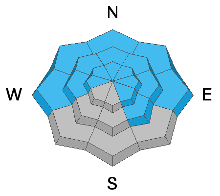
Persistent weak layers of weak, sugary, faceted snow are present on most aspects and elevations. On northerly-facing slopes, slabs 2'-3' deep exist on top of these weak layers. While recent warm temperatures and time have helped the snowpack gain some strength, dangerous avalanches remain ripe for human triggers, and they may break wider and deeper than you would expect. Give steep terrain a wide margin and stick to slopes less than 30 degrees. Chris Benson details the current state of the snowpack in the video below.
Avalanche Problem #2
Wind Drifted Snow
Type
Location
Likelihood
Size
Description
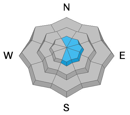
There isn't a lot of snow available for transport but winds have been patiently eroding westerly aspects and loading snow on to more easterly ones. Recent wind drifts are recognizable by their smooth rounded appearance and they may sound or feel hollow like a drum. Wind deposited snow will add additional stress to buried persistent weak layers and travel advice remains the same. Avoid slopes steeper than 30 degrees, especially those with a north or easterly component to their aspect.
General Announcements
This forecast is from the U.S. Forest Service, which is solely responsible for its content. This forecast describes general avalanche conditions and local variations always occur.