Join us at our 2nd Annual Blizzard Ball

Forecast for the Moab Area Mountains

Eric Trenbeath
Issued by Eric Trenbeath on
Monday morning, February 8, 2021
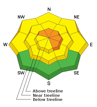
The avalanche danger remains CONSIDERABLE on steep slopes above treeline facing NW-NE-SE, and deep and dangerous human triggered avalanches failing on a buried persistent weak layer are likely in these areas. Recent deposits of wind drifted snow have added additional stress in these areas. Avalanches can be triggered from a distance and break wider and farther than expected. A MODERATE avalanche danger exists near treeline and below. Generally, LOW danger can be found on low elevation, south-facing terrain.
Low
Moderate
Considerable
High
Extreme
Learn how to read the forecast here
Special Announcements
We are filled with grief to report four fatalities from a skier triggered avalanche in the Wasatch Mountains on Saturday. All were well known members of the backcountry community. Here is the preliminary report. In a little over a week, there have been 15 avalanche fatalities across the U.S. Conditions are dangerous in most regions and ours is no exception. Please stay conservative in your terrain choices.

The Geyser Pass Road is plowed. Conditions are snow-packed and icy and all-wheel drive is recommended.
The Lower Utah Nordic Alliance (LUNA) groomed all trails on Saturday.
Weather and Snow
24 Hour Snow 0" 72 Hour Snow 0" Base Depth in Gold Basin 38" Wind WSW 15-25 Temp 18F
Winds bumped up and shifted back to the WSW overnight. Expect them to swing more westerly today averaging 15-25 mph with gusts to 30 mph along ridge tops. Skies will be mostly sunny with high temps at 10,000' near 30F. Look for increasing clouds overnight ahead of a weak system that will bring a slight chance for snow Tue-Wed. Long-range models are now hinting at a series of systems beginning to impact the area starting this weekend. Keep your fingers crossed.
Wind, temperature, humidity on Pre Laurel Peak (11,700')
Snotel site near Geyser Pass Trailhead (9600')
Storm totals at the Gold Basin study plot (10,000')
Snowpack Discussion
Wind and warm temperatures have created variable conditions but settled powder can still be found below treeline on sheltered northerly aspects. On sunny slopes, the snow surface has crusted over and coverage remains quite thin. Moderate westerly winds this week have scoured exposed, windward slopes while alternately loading leeward, easterly facing slopes. Cross loading has also occurred on slopes facing NW-N and in our travels yesterday I observed fresh drifts on these aspects. On NW-N-E aspects, dangerous slabs 2'-3' deep are perched above the weak underlying snowpack. These slabs are growing more stubborn by the day but the underlying poor snowpack structure doesn't inspire confidence.
Travis Nauman and Kelly Quinn sent in this observation from yesterday. Chris Benson did a flyover of both the La Sal and Abajo mountains yesterday. He submitted this observation and shot the following aerial footage.
Recent Avalanches
In his aerial travels Saturday, Chris Benson noted this fairly recent avalanche in Beaver Basin though the actual date is unknown.
Ad
Avalanche Problem #1
Persistent Weak Layer
Type
Location
Likelihood
Size
Description
Persistent weak layers of weak, sugary, faceted snow are present on most aspects and elevations. In our travels, yesterday we focused on slopes facing the west half of the compass. To be sure, we found plenty of weak, sugary snow on slopes facing WSW. In isolated areas, we were able to find a reactive slab over facets, but overall spotty coverage and lack of a continuous slab made this aspect less concerning. On slopes facing NW-N-E slabs 2'-3' deep exist on top of these weak layers. While recent warm temperatures and time have helped the snowpack gain some strength, deep and dangerous, human triggered avalanches remain possible in these areas. The danger increases with elevation and human triggered avalanches remain likely above treeline, particularly on slopes with recent deposits of wind drifted snow.
Avalanche Problem #2
Wind Drifted Snow
Type
Location
Likelihood
Size
Description
There isn't a lot of snow available for transport but winds have been patiently eroding south and westerly aspects and loading snow on to more northeasterly ones. Crossloading has also occurred on slopes facing NW. Recent wind drifts are recognizable by their smooth rounded appearance and they may sound or feel hollow like a drum. Wind deposited snow will add additional stress to buried persistent weak layers and travel advice remains the same. Avoid northerly facing slopes steeper than 30 degrees, especially those with an easterly component to their aspect.
General Announcements
This forecast is from the U.S. Forest Service, which is solely responsible for its content. This forecast describes general avalanche conditions and local variations always occur.