Join us at our 2nd Annual Blizzard Ball

Forecast for the Moab Area Mountains

Eric Trenbeath
Issued by Eric Trenbeath on
Saturday morning, February 6, 2021
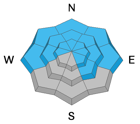
The avalanche danger remains CONSIDERABLE near treeline and above on steep slopes facing NW-NE-SE and deep and dangerous human triggered avalanches failing on a buried persistent weak layer are likely in these areas. Easterly facing slopes with recent deposits of wind drifted snow are the most suspect. Avalanches can be triggered from a distance and break wider and farther than expected. A MODERATE avalanche danger exists below treeline. Generally, LOW danger can be found on low elevation, south-facing terrain.
Low
Moderate
Considerable
High
Extreme
Learn how to read the forecast here
Special Announcements
In the last week, there have been 10 avalanche fatalities - 3 skiers in Colorado, 1 skier in Colorado, 3 hikers in Alaska, 1 skier in New Hampshire, 1 skier in California, and 1 skier in Utah on Square Top Mountain near Park City. Conditions are dangerous in most regions, and ours is no exception. Please stay conservative in your terrain choices.

The Geyser Pass Road is plowed. Conditions are snow-packed and icy and all-wheel drive is recommended.
The Lower Utah Nordic Alliance (LUNA) has not groomed since mid-week and surfaces are getting rough.
Weather and Snow
24 Hour Snow 0" 72 Hour Snow 2" Base Depth in Gold Basin 40" Wind NW 15-25 Temp 4F
Sunny and breezy conditions are on tap for the next few days as we remain under the influence of northwest flow aloft and a tight pressure gradient along the upstream side of a trough. Westerly ridgetop winds will blow in the 15-20 mph range with gusts in the 30's. High temps will be in the low 20's at 10,000'. A weak system will bring a slight chance for snow on Wed. Long-range model solutions are all over the place after that but none of them look particularly promising at the moment.
Wind, temperature, humidity on Pre Laurel Peak (11,700')
Snotel site near Geyser Pass Trailhead (9600')
Storm totals at the Gold Basin study plot (10,000')
Snowpack Discussion
It's now been a week since our last significant snowfall and conditions are variable. Warm temperatures have settled and consolidated last week's storm snow and the surface is tired and worn. On sunny aspects, the snow surface has crusted over. Moderate SW-NW winds have scoured exposed, windward slopes while alternately loading leeward, easterly facing slopes. On NW-N-E aspects, dangerous slabs 2'-3' deep are perched above the weak underlying snowpack. These slabs are growing more stubborn by the day but they remain primed and ready for human triggers.
Ad
Avalanche Problem #1
Persistent Weak Layer
Type
Location
Likelihood
Size
Description
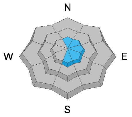
Persistent weak layers of weak, sugary, faceted snow are present on most aspects and elevations. On northerly-facing slopes, slabs 2'-3' deep exist on top of these weak layers. While recent warm temperatures and time have helped the snowpack gain some strength, dangerous avalanches remain ripe for human triggers, and they may break wider and deeper than you would expect. Give steep terrain a wide margin and stick to slopes less than 30 degrees. Chris Benson details the current state of the snowpack in the video below.
Avalanche Problem #2
Wind Drifted Snow
Type
Location
Likelihood
Size
Description
There isn't a lot of snow available for transport but winds have been patiently eroding westerly aspects and loading snow on to more easterly ones. Recent wind drifts are recognizable by their smooth rounded appearance and they may sound or feel hollow like a drum. Wind deposited snow will add additional stress to buried persistent weak layers and travel advice remains the same. Avoid slopes steeper than 30 degrees, especially those with a north or easterly component to their aspect.
General Announcements
This forecast is from the U.S. Forest Service, which is solely responsible for its content. This forecast describes general avalanche conditions and local variations always occur.