Join us at our 2nd Annual Blizzard Ball

Forecast for the Salt Lake Area Mountains

Trent Meisenheimer
Issued by Trent Meisenheimer on
Sunday morning, January 26, 2020
The avalanche danger is LOW on all aspects and elevations. Remember LOW danger does not mean there is NO danger in the mountains today. Watch for unstable snow on isolated terrain features.
Even small avalanches in steep sustained terrain can be fatal if you're taken for a ride. Use safe travel protocol by only exposing one person at a time to avalanche terrain. Carry rescue gear and keep an eye on your partner.
Low
Moderate
Considerable
High
Extreme
Learn how to read the forecast here
Special Announcements
NEW UAC Podcast: The Art of Storytelling Through Film - A Conversation with Trent Meisenheimer check it out HERE.
NEW UAC BLOG: The Anthropology of Risk - How Did We Get Here? Find it HERE.

Join Drew Hardesty: At the new Black Diamond Store at Trolley Square at 7:00 PM on January 27th for a Fireside Chat on Expert Intuition and the Avalanche Problem.
Weather and Snow
If you're awake and moving this morning it could be a beautiful sunrise in the mountains with mild temperatures and partly cloudy skies. By mid morning the clouds will begin to fill in ahead of a quick moving trough that will slice through northern Utah in overnight hours. Winds have backed to the west this morning and will eventually start to blow out of the southwest by this evening. As the trough axis passes overhead (7:00 - 9:00 PM) the winds will veer to the northwest and we could see 4"-7" of new snow by tomorrow morning. This quick hitting storm will be finished by mid day Monday. A brief break in weather on Tuesday followed by another trough Tuesday night that looks to have some better dynamics associated with it. We then ridge up for the remaining part of the week before getting back into an active pattern the following week.
Current mountain temperatures are in the mid 20's °F across the board. Winds are generally from the west and are blowing 5-15 mph across the upper elevation terrain. The southerly facing slopes took in heat yesterday and many of them will be crusted this morning. High in the alpine terrain many observers noted a significant amount of wind damage from the northerly winds. However, it's truly a winter wonderland out there with rime caked on the rocks and trees making it look like a scene from the Pacific Northwest. The best and softest snow will be found on northerly facing terrain that was sheltered from the wind and sun.

Our Week in Review which summarizes significant avalanche and weather events from this past week has been published. Click HERE.
Photo: Greg Gagne, yesterday in the alpine with rime plastered on all the rocks. Winter wonderland.
Recent Avalanches
Many people were out in the mountains yesterday and we had four reported avalanches. Below is a list of the reported avalanches and if you're confused on where these are be sure to check out the Wasatch Backcountry Ski Map to find their locations. One important avalanche to take note of was another natural Glide avalanche from Broads Fork. Many observers noted small loose wet avalanches on the southerly facing slopes from daytime heating. Check out all the observations HERE.
Stupid Chute: north facing slope 10,300' - 3" deep 10' wide.
Little Superior Buttress: northeast facing slope 9,800' - 8" deep 70' wide.
Broads Fork: northeast facing slope 9,200' - 6' deep 80' wide. Natural Glide avalanche.
Ad
Avalanche Problem #1
Normal Caution
Type
Location
Likelihood
Size
Description
Remember that LOW danger does not mean there is NO danger. Mountain travel is inherently risky. As the avalanche danger decreases we typically choose bigger terrain objectives and we need to remember that even a small avalanche can have serious consequences in steep sustained terrain. We need to assess each and every slope we ride or travel on. Look for snow that has been effected by the wind and use the terrain to move around those areas.
Wind Drifted Snow: Yesterday and today's winds are just steady enough to blow and move the fresh powder onto lee aspects across the upper elevation ridgelines. Be cautious of your first few turns off the steep ridgelines where you could trigger a small wind drifted snow avalanche. Steep mid slope break-overs and cross loaded gullies will also be a concern where there is a chance a small avalanche could release within the new snow.
Glide Avalanche: With spring like temperatures and the report of two very large glide avalanches in Broads Fork we need to take this problem seriously for today. There is classic terrain where glide avalanches can release unexpectedly. Places like Broads Fork (Bonkers, Diving Board, Blue Ice), Stairs Gulch, and Mill B South are all suspect and travel beneath the rock slabs is not recommended.
Cornice: Many ridgelines now have large and overhanging cornices. As you travel along ridgelines be sure to give cornices a wide berth as they typically break much further back than expected.
Additional Information
Wondering what happened to the Persistent Weak Layer problem? well, truthfully it's still there and one needs to be aware of this layer and extra caution is advised if you're traveling in very steep, shallow, outlying terrain. It's most prominent on slopes that face SE, S, SW and west that have a much shallower snowpack.
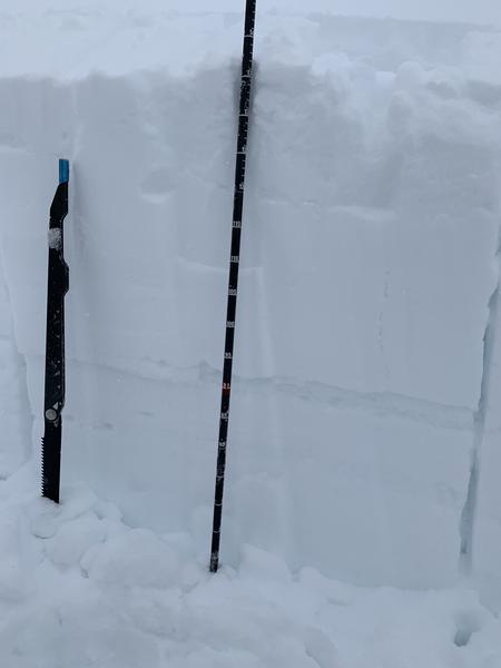
It's hard to ignore the very large avalanche that was triggered in Mill B South a week ago. Drew Hardesty and I went to look at this avalanche on Friday and you can find our observation HERE. Mark Staples went and looked at another avalanche in Dry Fork and has a great snowpit profile of these crusts. Much of the snowpack across the Wasatch range is deep and strong and this layer is not a concern.
Travel Advice: Ride the north half of the compass where the snowpack is deep and strong. Avoid steep southerly aspects that have a shallow snowpack.
Photo: Mill B South weak layer and crust combination. This was a west facing slope at 10,000' in elevation.
General Announcements
This information does not apply to developed ski areas or highways where avalanche control is normally done. This forecast is from the U.S.D.A. Forest Service, which is solely responsible for its content. This forecast describes general avalanche conditions and local variations always occur.