Greg Gagne
Forecaster
Our Week in Review highlights significant snowfall, weather, and avalanche events of the previous week. (Click here to review the archived forecasts for the Salt Lake mountains.)
The danger roses for the Salt Lake mountains from Friday, January 17 through Thursday, January 23, 2020:

Summary: An over-producing storm system on Friday, January 17, with additional snowfall midweek. Snow and water totals for the period include:
- Upper Cottonwoods: 24 - 36" snow with 2.4 - 3.4" water
- Park City Ridgeline: 16 - 20" snow with 1.3 - 1.5" water
We are very sad to report an avalanche fatality that occurred on Saturday, January 18 above Farmington Canyon. An 18-year-old male snowmobiler was caught, fully buried and killed. The final report is available HERE. Our deepest condolences go out to the friends, family, rescuers, and others affected by this tragic accident.
Friday, January 17: A storm system enters the region early morning, with snowfall rates of 2-3" an hour. Upper Cottonwoods receive 12-18", with several avalanches reported during the day, including this natural avalanche from The Y and Y-Not Couloirs in Little Cottonwood Canyon (video from Utah Dept. of Transportation):
Saturday, January 18: A few avalanches occurring in wind-drifted snow are reported. These were generally 5-10" deep and up to 50' wide. Tragically, an avalanche in Farmington Canyon claims the life on an 18-year old snowmobiler.
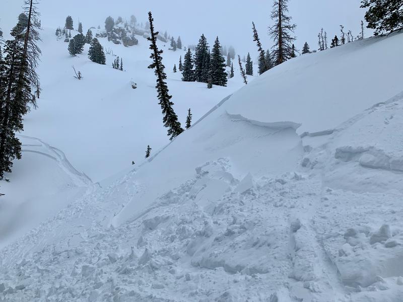
Sunday, January 19: A significant avalanche in Mill B South of Big Cottonwood Canyon. It failed on a persistent weak layer of facets above a crust that formed right around the New Year. (Observation)
The third of a party of three, while traversing high along the Mill B South and Mineral Fork ridgeline, triggered and was briefly caught and carried in an estimated 12-18" deep and 100' wide soft slab avalanche. The initial avalanche in turn sympathetically triggered a similar one, estimated to be 400' wide...and perhaps a third, along the ridgeline heading north. These avalanches are on steep west to southwest facing slopes at 10,200'.

On Tuesday, Nikki visited this slide and provides further details in her observation.
Monday, January 20: Overcast skies with no backcountry avalanches reported.
Tuesday, January 21: 3-6" of dense, new snow. No backcountry avalanches are reported.
Wednesday, January 22: 4-8" of new snow with increased winds from the west/northwest. Avalanches failing within storm snow are reported, with most occurring in dense slabs of wind-drifted snow, including this small avalanche on the Hallway Couloir in Cardiff Fork of Big Cottonwood Canyon (observation):
Thursday, January 23: Continued snowfall overnight and into early Thursday morning. Storm totals since Tuesday are 14-18" in the upper Cottonwoods (containing 1.5-2..25" of water) and generally 8" of snow along the Park City ridgeline. A few backcountry avalanches are reported, including this slide triggered by a snowmobiler in Dry Fork Creek. This was on a southwest aspect at 9,500' It was 2' and 50' wide.