Join us at our 2nd Annual Blizzard Ball

Forecast for the Salt Lake Area Mountains

Drew Hardesty
Issued by Drew Hardesty on
Monday morning, January 27, 2020
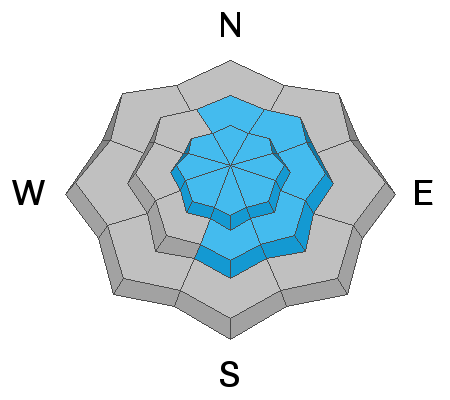
We start at CONSIDERABLE DANGER this morning for new and developing wind drifts and new snow instabilities. Human triggered avalanches are probable and more concentrated along the higher elevation bands and to the lee of the mid-elevation exposed ridgelines. With the storm winding down, the danger will likely trend toward MODERATE by the afternoon.
Low
Moderate
Considerable
High
Extreme
Learn how to read the forecast here
Special Announcements
NEW UAC Podcast: The Art of Storytelling Through Film - A Conversation with Trent Meisenheimer check it out HERE.
NEW UAC BLOG: The Anthropology of Risk - How Did We Get Here? Find it HERE.

Join Drew Hardesty: At the new Black Diamond Store at Trolley Square tonight at 7:00 PM for a Fireside Chat on Expert Intuition and the Avalanche Problem.
Weather and Snow
Underpromise and overdeliver.
Storm totals so far in the upper Cottonwoods are 10"(0.85"SWE) with 6.5" (0.48"SWE) along the Park City ridgeline. It's still snowing.
Winds are 15-20mph from the northwest with gusts to 70mph at the 11,000' level. Temps have fallen into the teens and low 20s.
The storm will start to wind down and turn more showery this morning.

Looking down the road, we'll stay cool and unsettled with another minor storm slated for tomorrow night into Wednesday with sunny skies and warm temps expected for the weekend.
Did I mention warm? Weekend ridgetop temps may reach into the mid-40s. It is February by then, after all. The heat wave should be brief; however, the models do bring a strong cold front on Monday.
Recent Avalanches
Owing to high rates of snowfall, something of a shallow new snow natural avalanche cycle ran its course at 2am this morning.
No significant reports of avalanche activity noted from yesterday, although there was a close-call in the Y-Not Couloir in lower LCC yesterday.
Ad
Avalanche Problem #1
Wind Drifted Snow
Type
Location
Likelihood
Size
Description
Sensitive slabs of wind drifted snow will be encountered along the mid- to higher elevations and to the lee of terrain features such as ridgelines, sub-ridges, scoops and rocky outcrops. They'll be more prominent on terrain with an easterly component and may present as smooth, rippled and pillowy. Shooting cracks will be evident in wind drifted terrain. Winds are forecast to remain strong enough from the northwest to continue drifting snow over the course of the day (15-20mph).
TREND: Steady
Avalanche Problem #2
New Snow
Type
Location
Likelihood
Size
Description
Two clues to the instability this morning:
  • Natural activity in the early morning
  • Avalanche workers are noting an upside down nature of the storm snow
These new snow avalanches have a number of crusts to run upon and may allow for larger debris piles, particularly in steep walled gullies and dramatic transitions in terrain (steep to quickly flat).
TREND: Decreasing danger
Additional Information
Glide Avalanche: Large bone shattering glide avalanches have run in Broads Fork of BCC in recent days. Broads Fork (Bonkers, Diving Board, Blue Ice), Stairs Gulch, and Mill B South are all suspect and travel beneath the rock slabs is not recommended.
Cornice: Many ridgelines now have large and overhanging cornices. As you travel along ridgelines be sure to give cornices a wide berth as they typically break much further back than expected.
General Announcements
This information does not apply to developed ski areas or highways where avalanche control is normally done. This forecast is from the U.S.D.A. Forest Service, which is solely responsible for its content. This forecast describes general avalanche conditions and local variations always occur.