Sign Up for the Utah Snow and Avalanche Workshop (USAW) on December 7th!

Forecast for the Moab Area Mountains

Eric Trenbeath
Issued by Eric Trenbeath on
Saturday morning, November 24, 2018
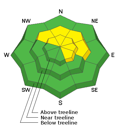
The avalanche danger will rise to MODERATE today as fresh deposits of wind drifted snow begin to form on the lee sides of ridge crests and terrain features in upper elevation, wind exposed terrain. On slopes that face NW-N-E, the wind drifted snow will be sitting on top of loose, weak, sugary, faceted snow, and the potential for triggering a deeper avalanche exists in these areas. Back country travelers should be alert to recent deposits of wind drifted snow, and avoid steep slopes where it is present.
Low
Moderate
Considerable
High
Extreme
Learn how to read the forecast here
Weather and Snow
Clouds are building over the mountains and WSW winds are cranking in the 25-30 mph range with gusts into the 40's. Though I expect more huff than fluff, snow showers should begin around 11:00 and continue into the afternoon. 3"-5" are possible. High temps at 10,000' will be in the mid 20's and we are already there at 27 degrees in Gold Basin. Look for a drop as the cold front moves through. Temperatures will plummet into the single digits tonight, and we'll see dry conditions through Wednesday, when the models begin to advertise a more active pattern.
18"-30" of snow exists on the ground above 10,000' on NW-N-E aspects, the problem is getting to it. Sun exposed are mostly melted out and coverage at mid elevations is exceedingly thin. We need at least a foot, and more realistically, two feet of snow before we can call it officially game on.
New snow totals in Gold Basin (10,000')
Snow totals at the Geyser Pass Trailhead (9600')
Wind, temperature, and humidity on Pre Laurel Peak (11,700')
National Weather Service point forecast.
Ad
Avalanche Problem #1
Wind Drifted Snow
Type
Location
Likelihood
Size
Description
Today be on the lookout for areas of recently deposited, wind drifted snow. Otherwise known as wind slabs, these deposits will form on the lee sides of ridge crests and terrain features in wind exposed terrain. With only a few inches of snow in the forecast, these deposits should be mostly shallow, but on slopes that face NW-N-E, they could step down into buried weak layers of loose, sugary, faceted snow causing a deeper and more dangerous avalanche.
Avalanche Problem #2
Persistent Weak Layer
Type
Location
Likelihood
Size
Description
The snow that has been sitting on the ground since mid-October has developed layers of loose, weak, sugary, faceted snow. This storm doesn't appear to be bringing much of a load, but a triggered wind slab has the potential for stepping down into a buried weak layer causing a deeper and more dangerous avalanche, particularly when one considers a bumpy ride across the ground. Areas of concern are on steep slopes that face NW-N-E.
General Announcements
We are very proud to introduce our new website for the 2018-19 winter season. This will provide an easier and cleaner way to view all of the snow and avalanche information that you've come to rely on. We are quite happy with how the new website performs on mobile devices as well. We think you'll find the desktop or laptop experience pleasant as well. We are still tying up some loose ends so bear with us.